Canada has numerous cities and towns, each with its unique culture, history, and geography. Navigating this vast landscape can be challenging, so Canada Maps has created a comprehensive map showing the provinces and territories, the major cities and towns, and the roads that connect them.
What are Such Maps Used for?
This map is an essential resource for anyone planning a road trip, exploring new regions of Canada, or conducting research on urban and rural communities. It provides a clear and comprehensive overview of the various cities and towns across Canada and the roads that connect them.
Map of Canada with cities
This map shows Canada’s provinces, territories, cities, towns, and roads.
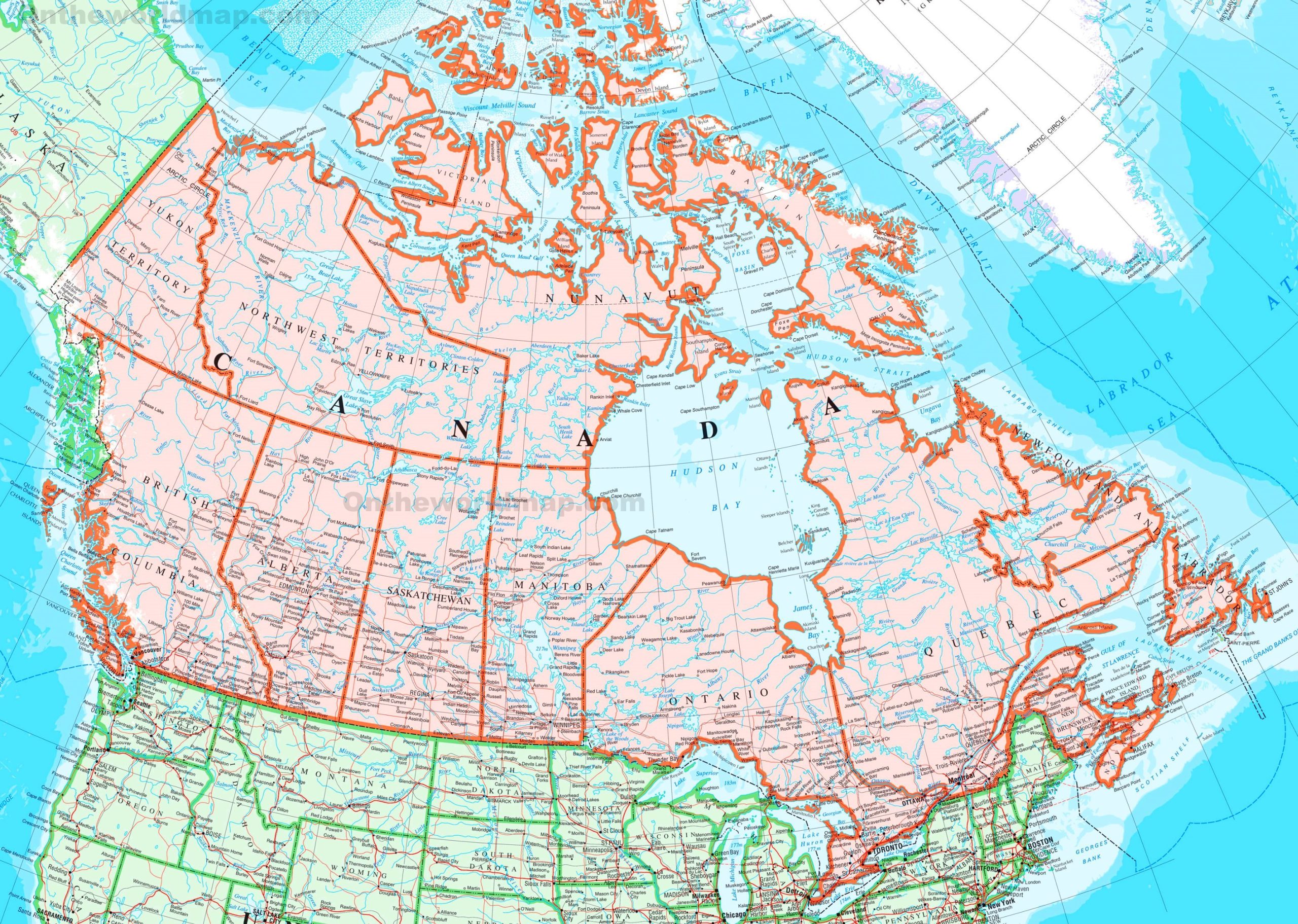
The map of Canada with cities, measuring 2560 by 1822 pixels, is a comprehensive visual guide to the country’s urban landscape. It likely features a wide array of cities from coast to coast, including major metropolitan areas and smaller towns, providing a clear picture of Canada’s populated regions.
This map is an essential tool for understanding the geographical distribution of Canadian cities, their proximity to natural landmarks like lakes and mountains, and their connectivity through major transportation routes. It would be particularly useful for planning travel, understanding regional demographics, or studying the country’s urban development.
The presence of cities such as Toronto, Vancouver, Montreal, Calgary, and Ottawa, among others, would be prominent, each marked by their geographical features and surrounding smaller towns and communities. The map may also provide insight into these cities’ diverse landscapes, from the coastal edges of the Pacific and Atlantic Oceans to the interior plains and northern tundra.
For anyone interested in Canadian geography, urban planning, or exploring the country, this map serves as a detailed starting point to delve into the rich tapestry of Canada’s cities.
Did You Know About Canada?
Canada’s grandeur extends beyond its sheer size to encompass a wealth of natural and cultural treasures. As the second-largest country globally, it offers an array of landscapes, from the rugged coastlines of the Atlantic to the Rocky Mountains’ peaks and the Arctic’s frozen expanses.
The population of Canada, while modest compared to its landmass, is concentrated in cities and towns that dot the landscape, each with its own character and history. These urban centers are often gateways to the surrounding natural beauty and are hubs of cultural diversity, reflecting the country’s rich mosaic of communities.
The presence of three of the world’s largest lakes within its borders speaks to Canada’s abundance of freshwater resources. Lake Superior, the largest of the Great Lakes, straddles the border with the United States and is a hub for commerce and recreation. Lake Huron, known for its beautiful shorelines and a vital part of the Great Lakes system, supports numerous communities along its banks. Great Bear Lake in the Northwest Territories is the largest lake entirely within Canada and is a pristine wilderness area, reflecting the country’s commitment to preserving its natural environment.
Canada’s wildlife is as varied as its geography. The polar bear, synonymous with the Canadian Arctic, symbolizes the country’s wild and untamed nature. The moose, found across Canada’s forests, is an iconic figure in Canadian wildlife. The beaver, Canada’s national animal, is a testament to the country’s rich fur trade history, which played a crucial role in the nation’s development.
The national parks of Canada are custodians of the country’s natural heritage. They offer a sanctuary for wildlife and a retreat for those seeking to connect with nature. From the remote tundra of Nunavut’s Quttinirpaaq National Park to the mountainous terrain of British Columbia’s Pacific Rim National Park Reserve, these parks provide a cross-section of Canada’s ecological diversity.
Roads into these parks not only make Canada’s natural beauty accessible but also serve as scenic byways, offering some of the most breathtaking drives in the world. The Trans-Canada Highway, for instance, stretches from the Atlantic to the Pacific, offering a journey through a variety of landscapes that define Canada.
For visitors, Canada is not just a destination; it is an experience that combines the vastness of its landscapes with the warmth of its cities and the spirit of its people. It is a country where each province and territory tells a part of the national story, inviting explorers to discover its many wonders.
Conclusion
Canada Maps’ map of provinces, territories, cities, towns, and roads is essential for anyone interested in exploring Canada’s urban and rural communities. Whether planning a road trip, researching different regions of Canada, or simply curious about the country’s geography, this map provides a clear and comprehensive overview of Canada’s cities and towns and the roads that connect them.
With its detailed visuals and extensive coverage, this map is an excellent tool for exploring Canada’s diverse regions, from the bustling cities of Toronto, Montreal, and Vancouver to the charming small towns of the Maritimes and the Prairies.