Tourist Map

Home » Tourist Map

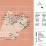
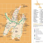
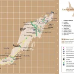
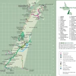
Discover the Best of the Northwest Territories with a Tourist Map

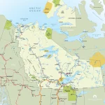
This map shows cities, towns, rivers, lakes, heritage rivers, Trans-Canada trail, paved surface, unpaved surface, dempster highways, canol hiking routes, Ingraham trails, liard trails, frontier trails, great slave routes, waterfalls routes, wood buffalo routes, ferries, historical sites, day use parks, national parks, diamond mines, and visitor information centers.

Home » Tourist Map

Explore the Beauty of Central Newfoundland with this Tourist Map

This map shows cities, towns, the Trans-Canada highway, secondary roads, national parks, provincial parks, campgrounds, provincial/national historic sites, airports, local ferries, summer ferries, ski areas, golf courses, and provincial visitor information centers in Central Newfoundland.

Home » Tourist Map

Discovering Avalon: A Tourist Map Guide for Exploring Canada’s Eastern Coast

This map shows cities, towns, Trans-Canada highways, secondary roads, national parks, provincial parks, campgrounds, provincial/national historic sites, airports, local ferries, summer ferries, ski areas, golf courses, and provincial visitor information centers in Avalon.

Home » Tourist Map

Explore Eastern Newfoundland with a Comprehensive Tourist Map

This map shows cities, towns, the Trans-Canada highway, secondary roads, national parks, provincial parks, campgrounds, provincial/national historic sites, airports, local ferries, summer ferries, ski areas, golf courses, and provincial visitor information centers in Eastern Newfoundland.

Home » Tourist Map

Explore Western Newfoundland with a Detailed Tourist Map

This map shows cities, towns, the Trans-Canada highway, secondary roads, national parks, provincial parks, campgrounds, provincial/national historic sites, airports, local ferries, summer ferries, ski areas, golf courses, and provincial visitor information centers in Western Newfoundland.

Home » Tourist Map

Discover Saskatchewan with the Ultimate Tourist Map

This map shows cities, towns, rivers, lakes, the Trans-Canada highway, major highways, secondary roads, winter roads, CANAM highway, northern woods, and water routes, the Saskota travel route, veterans memorial highway, red coat trail, Louis riel trail, chief whitecap trail, national parks, provincial parks, historic sites, ecological reserves, Indian reservations, regional parks, campgrounds, airports, ferries, tourism visitor reception centers and rest areas in Saskatchewan.

Home » Tourist Map

Discover the Best of Prince Edward Island with this Tourist Map

This map shows cities, towns, rivers, lakes, highways, major roads, secondary roads, confederation trail, north cape coastal drive, blu heron scenic drive, points east coastal drive, scenic heritage roads, kilometer distance, islands welcome centers, beaches, campgrounds, accommodations, heritage sites, museums, parks, washrooms, lighthouses, scenic views and theatres in Prince Edward Island.