Unveiling the Mysteries of the Arctic Circle: A Comprehensive Guide
The Arctic Circle is not just a line of latitude; it’s a gateway to an extraordinary world. Situated at approximately 66°33′ N, this parallel marks the boundary of Earth’s northernmost region. In Canada, it passes through communities like Old Crow in the Yukon and Fort McPherson in the Northwest Territories. But what makes this region so special? From the mesmerizing phenomena of the Midnight Sun and Polar Night to the challenges and opportunities of life in the Arctic, this guide will take you on an enlightening journey.
The definition of the Arctic Circle
The Arctic Circle is an imaginary line of latitude located approximately 66.3 degrees north of the Equator. This circle marks the southernmost point in the Northern Hemisphere at which the sun can remain continuously above or below the horizon for 24 hours; these phenomena are known respectively as the Midnight Sun in summer and the Polar Night in winter. This occurs due to the tilt of the Earth’s axis about its orbit around the sun.
The region within the Arctic Circle is known as the Arctic characterized by a unique environment, including extreme conditions and a distinct ecosystem. This area experiences significant variations in daylight hours throughout the year, ranging from 24-hour daylight in the summer to complete darkness in the winter. The Arctic is also defined by its cold climate, ice-covered waters, and permafrost, although the exact environmental conditions can vary greatly across different parts of the Arctic.
The Arctic Circle’s position is not fixed; it actually moves slightly over time due to changes in the Earth’s axial tilt and other factors. This movement, however, is relatively minor in the context of human time scales. The Arctic region plays a crucial role in the Earth’s climate system. It is an area of significant interest for climate science, especially in global warming and its impacts on polar ice, ecosystems, and indigenous communities.
Map of the Arctic Region
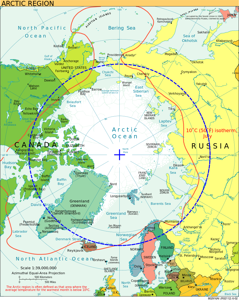
This map comprehensively represents the Arctic, capturing its geographical, climatic, and political facets. It can serve as a helpful tool for understanding the complexities of this critical and unique world region.
The map portrays the Arctic region and highlights several key features:
- Arctic Region: This is the area around the North Pole. It encompasses parts of Russia, Canada, the United States (specifically Alaska), Greenland (which is a territory of Denmark), Norway, and a few other countries. It’s defined by its cold climate, unique ecosystems, and the presence of the Arctic Ocean.
- 10°C (50°F) Isotherm: This line represents the boundary where the average temperature for the warmest month is below 10°C. Areas within this line are average cooler during their warmest month. The isotherm serves as a climatic definition of the boundary of the Arctic region.
- Countries and Territories: The map includes various countries and territories. For instance, you can see the northern parts of countries like Canada, Russia, Norway, and the United States. Greenland, which is denoted as belonging to Denmark, is also visible.
- Oceans and Seas: The map displays various bodies of water like the Arctic Ocean, North Atlantic Ocean, Barents Sea, Norwegian Sea, and others. These waters play crucial roles in global climate regulation and marine biodiversity.
- Major Cities and Locations: Prominent cities and locations within the Arctic region or close to its boundaries are shown. For example, cities like Anchorage, Fairbanks, Reykjavik, and Murmansk are labeled.
- Roads and Infrastructure: The map marks certain major roads or transportation routes, particularly in areas like Canada and Alaska.
- Islands: Numerous islands, such as Norway’s Svalbard archipelago and the U.S.’s Aleutian Islands, are visible.
- Scale and Projection: At the bottom, you’ll notice details about the map’s scale and the type of projection used. The “Azimuthal Equal-Area Projection” ensures that areas are represented proportionally, which can be particularly useful for understanding the vastness of the Arctic region.
- Definition: The map briefly defines the Arctic region, emphasizing that it’s often characterized by areas where the average temperature for the warmest month is below 10°C.
The Dance of Light and Darkness: Solstices, Midnight Sun, and Polar Night
The Arctic Circle serves as a demarcation line for unique solar phenomena. During the summer solstice, the sun never sets, creating what is known as the Midnight Sun. Conversely, the sun never rises during the winter solstice, leading to the Polar Night. These phenomena occur due to the tilt of the Earth’s axis and its orbit around the sun.
The Arctic Landscape: Where Geography Meets Human Habitation
Contrary to popular belief, the Arctic Circle doesn’t signify a sudden climate change. Trees grow north of it in places like the Mackenzie Delta in the Northwest Territories. Inuvik, also in the Mackenzie Delta, is the only moderately large Canadian settlement north of the circle and is accessible via the Dempster Highway.
Life in the Arctic: The Challenges and Triumphs
Climate change is affecting the Arctic almost twice as fast as the rest of the world. This has led to shifts in animal migration patterns and poses challenges to the Inuit communities that rely on traditional hunting. Resource development also threatens animal habitats, making adaptation and sustainable practices crucial for survival.
Wildlife Wonders: The Flora and Fauna of the Arctic
The Arctic is home to various wildlife, from walruses to seals, which are integral to the Inuit way of life. The changing climate and human activities affect these species, but they remain vital to the Arctic ecosystem.
Did You Know?
- The Arctic Circle’s latitude shifts slightly due to the tilt of Earth’s rotational axis.
- Inuvik is the only moderately large Canadian settlement north of the Arctic Circle.
- The Arctic is warming almost twice as fast as the global average.
- The Midnight Sun and Polar Night phenomena are due to the tilt of the Earth’s axis.
- The Inuit are observing changes in the migration patterns and population numbers of Arctic animals due to climate change.
Google Maps of the Arctic Region
Conclusion
In summary, the Arctic Circle is much more than a mere geographical boundary; it represents a unique and dynamic region of our planet with profound significance. This guide has taken you through the fascinating aspects of the Arctic Circle, from the enchanting phenomena of the Midnight Sun and Polar Night to the challenges faced by the indigenous communities and wildlife due to climate change. The Arctic Circle’s significance extends beyond its physical location, influencing global climate patterns, ecosystems, and human cultures.
As the Arctic continues to experience rapid environmental changes, understanding this region becomes increasingly important. The Arctic Circle is a testament to the resilience of life in extreme conditions and a reminder of the delicate balance that sustains our planet. Whether you are a researcher, an adventurer, or simply someone fascinated by the wonders of our world, the Arctic Circle offers a unique perspective on the interplay between nature and human existence.
By exploring the Arctic Circle, we not only gain insight into a remarkable part of the world but also understand the broader implications of environmental changes on a global scale. The journey through the Arctic Circle is a land of contrasts and discoveries, a place where the dance of light and darkness shapes life in profound ways.