Canada’s Formation in 1867: A Brief History of Confederation
In the mid-19th century, the British North American colonies faced numerous governance, security, and economic development challenges. To address these issues and create a stronger, more unified confederation, several colonies joined together in 1867 to form what is now known as Canada.
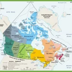
Ontario, Quebec, Nova Scotia, and New Brunswick, among the most populous and influential colonies at the time, agreed to unite under the terms of the British North America Act, which established a new dominion with its government, parliament, and prime minister. The Act also created a federal system of government, with powers divided between the central government and individual provinces, ensuring a greater degree of autonomy and self-governance for the newly formed country.
Soon after this historic amalgamation, Manitoba, a small western territory, joined the confederation, followed by several other provinces and territories over the years. This expansion and growth of the country contributed significantly to its economic and social development and helped to establish Canada as a significant player on the world stage.
Today, Canada is a prosperous and diverse nation known for its robust democratic institutions, strong economy, and commitment to social justice and human rights. Its unique identity as a bilingual, multicultural country reflects its rich history and vibrant present. At the same time, its ongoing efforts to address challenges such as climate change, inequality, and global conflict demonstrate its continued commitment to building a better future for all Canadians.