Ontario

Home » Ontario

Where is Ontario?

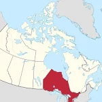
Located in eastern Canada, Ontario is the second-largest province by area and the most populous in the country. It borders four of the five Great Lakes – Superior, Huron, Erie, and Ontario – making it a destination known for its stunning waterfronts and picturesque landscapes.
Home » Ontario

Chatham Maps and Facts

Discover the comprehensive resource for Chatham Maps and Facts on Canada Maps.com. Detailed profile of Chatham, including essential demographic, economic, and social data. Easily understand and explore the cities of Ontario, use interactive maps, such as Google Maps, Traffic Map, and Satellite Map, to visually represent each city’s geography and location.

Home » Ontario

Toronto – Canada’s Multicultural Metropolis

Toronto, Canada’s largest city, is world-renowned for its diverse and multicultural population, making it one of the most cosmopolitan and inclusive cities on the planet. With residents from over 200 ethnic groups, Toronto offers a unique array of cultural traditions, languages, beliefs, foods, and customs. From the colorful festivities of Caribbean Carnival to the bustling streets of Chinatown, Little Italy, and Greektown, Toronto is a vibrant melting pot of culture, art, music, and diversity. Its dynamic and inclusive spirit has earned it a reputation as one of the world’s most welcoming and tolerant cities, where people from all walks of life can feel at home and celebrated for their differences.

Home » Ontario

Thunder Bay Maps and Facts

Discover the comprehensive resource for Thunder Bay Maps and Facts on Canada Maps.com. Detailed profile of Thunder Bay, including essential demographic, economic, and social data. Easily understand and explore the cities of Ontario, use interactive maps, such as Google Maps, Traffic Map, and Satellite Map, to visually represent each city’s geography and location.

Home » Ontario

Waterloo Maps and Facts

Discover the comprehensive resource for Waterloo Maps and Facts on Canada Maps.com. Detailed profile of Waterloo, including essential demographic, economic, and social data. Easily understand and explore the cities of Ontario, use interactive maps, such as Google Maps, Traffic Map, and Satellite Map, to visually represent each city’s geography and location.

Home » Ontario

Toronto Maps and Facts

Discover the comprehensive resource for Toronto Maps and Facts on Canada Maps.com. Detailed profile of Toronto, including essential demographic, economic, and social data. Easily understand and explore the cities of Ontario, use interactive maps, such as Google Maps, Traffic Map, and Satellite Map, to visually represent each city’s geography and location.

Home » Ontario

Ottawa Maps and Facts

Discover the comprehensive resource for Ottawa Maps and Facts on Canada Maps.com. Detailed profile of Ottawa, including essential demographic, economic, and social data. Easily understand and explore the cities of Ontario, use interactive maps, such as Google Maps, Traffic Map, and Satellite Map, to visually represent each city’s geography and location.

Home » Ontario

Hamilton Maps and Facts

Discover the comprehensive resource for Hamilton Maps and Facts on Canada Maps.com. Detailed profile of Hamilton, including essential demographic, economic, and social data. Easily understand and explore the cities of Ontario, use interactive maps, such as Google Maps, Traffic Map, and Satellite Map, to visually represent each city’s geography and location.

Home » Ontario

Discovering Wasaga Beach: The World’s Longest Freshwater Beach

Located along the southern shore of Georgian Bay in Ontario, Canada, Wasaga Beach is a breathtaking natural wonder that has become world-renowned for its beauty, scenic vistas, and recreational activities. This magnificent beach stretches over 14 kilometers (8.7 miles) along the shoreline, making it the longest freshwater beach in the world, attracting millions of visitors every year. The beach offers various activities for all ages, including swimming, sunbathing, hiking, cycling, and nature walks. Beyond the beach, visitors can explore the charming town of Wasaga Beach, which is home to vibrant shops, restaurants, and entertainment venues. Due to its unique geographic location, Wasaga Beach provides a rare opportunity to witness various natural ecosystems, including dunes, wetlands, and hardwood forests. Recognizing the importance of preserving this one-of-a-kind gem, Wasaga Beach has been officially designated as a protected area, with strict guidelines to ensure its long-term sustainability and ecological health. With its breathtaking beauty, endless recreational opportunities, and rich ecological diversity, Wasaga Beach remains an essential destination for anyone seeking to experience the wonders of Canada’s natural landscape.

Home » Ontario

Navigate Ontario with Ease: A Map of Highways, Cities, and Points of Interest

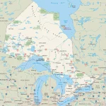
This map shows highways in Ontario. Cities, towns, counties, interprovince highways, Canada highways, province highways, main roads, secondary roads, rivers, lakes, airports, national parks, rest areas, welcome centers, Indian reservations, scenic byways, and points of interest in Ontario. Hotels, resorts, beaches, national parks, rest areas, welcome centers, Indian reservations, scenic byways, points of interest, tourist attractions, and sightseeing in Ontario.