highways

Home » highways

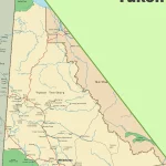
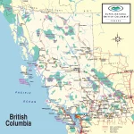
The Yukon Highway Map: Navigating the Northern Wilderness

This map shows highways in the Yukon.

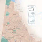
This detailed map provides a comprehensive view of the Yukon’s highways, main roads, secondary roads, and key natural features such as rivers, lakes, and national parks. With its user-friendly layout and easy-to-read design, the Yukon Highway Map is indispensable for anyone planning a road trip or exploring the territory’s many outdoor adventures.

Home » highways

Discover the Beauty of Newfoundland and Labrador with a Detailed Road Map

This map shows cities, towns, highways, main roads, secondary roads, rivers, lakes, national parks, and provincial parks in Newfoundland and Labrador.

Home » highways

Discover the Best of Prince Edward Island with this Tourist Map

This map shows cities, towns, rivers, lakes, highways, major roads, secondary roads, confederation trail, north cape coastal drive, blu heron scenic drive, points east coastal drive, scenic heritage roads, kilometer distance, islands welcome centers, beaches, campgrounds, accommodations, heritage sites, museums, parks, washrooms, lighthouses, scenic views and theatres in Prince Edward Island.

Home » highways

Explore British Columbia: British Columbia National Parks Map

This map shows cities, towns, rivers, lakes, highways, secondary roads, airports, reserves, national parks, and provincial parks in British Columbia.