Canada is a vast country with diverse landscapes, from the rugged Rocky Mountains to the rolling prairies of the Prairies, the vast boreal forests of the North, and the beautiful coasts of the East and West. Navigating this vast landscape can be daunting, which is why Canada Maps has created a comprehensive map that shows not only the provinces, territories, and their respective capitals but also the major cities, towns, highways, roads, railways, and rivers that connect them.
Detailed road map of Canada
This map shows Canada’s provinces, territories, provincial and territorial capitals, cities, towns, highways, roads, trans-Canada highways, railways, and rivers.
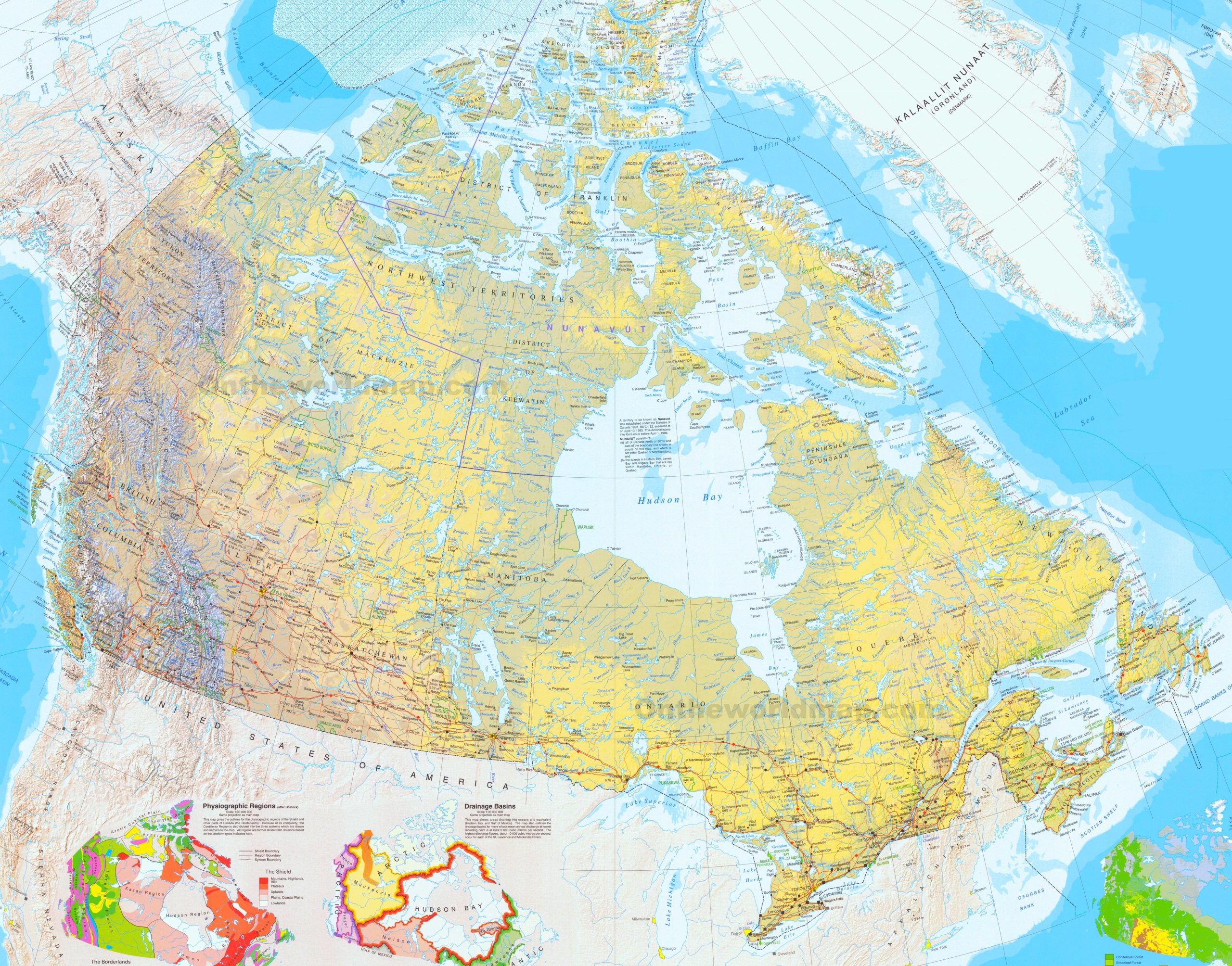
The road map of Canada, with a resolution of 2560 by 2008 pixels, is a detailed representation of the country’s extensive road network. It likely includes major highways, secondary roads, and possibly scenic routes, connecting Canada’s vast and diverse landscapes from coast to coast.
This map would be an invaluable resource for planning road trips, understanding the connectivity between different regions, and appreciating the scale of Canada’s transportation infrastructure. It would show the Trans-Canada Highway, which spans the country’s entire length, as well as other significant routes that facilitate travel and commerce within and across provinces and territories.
For those looking to explore Canada’s scenic beauty, such a map would highlight the routes that offer the most picturesque drives, such as those through the Rocky Mountains, along the Great Lakes, or across the prairies. It would also be a guide to the remote areas of the north, showcasing the roads leading to the country’s less-traveled parts.
What are Such Maps Used for?
This map is an essential resource for anyone planning a road trip, exploring new regions of Canada, or researching transportation networks and infrastructure. It provides a clear and comprehensive overview of the various modes of transportation that connect the different regions of Canada, as well as the natural features that define the country’s diverse landscapes.
Did You Know About Canada?
The Trans-Canada Highway is a ribbon of road that weaves together the vast tapestry of Canada’s landscapes, cultures, and communities. As the world’s longest national highway, it is a testament to the country’s commitment to connectivity and exploration. The journey along this highway is a cross-country adventure that offers a glimpse into the heart of Canada, from the rugged coastlines of British Columbia to the historic sites of Newfoundland and Labrador.
Along the way, travelers encounter diverse cities, each with its own story. Vancouver, with its Pacific Ocean backdrop, is a cosmopolitan city surrounded by nature. Calgary, the gateway to the Canadian Rockies, is a city that embodies the spirit of the West. Winnipeg stands as a cultural oasis in the prairies, while Toronto, Canada’s largest city, pulses with urban energy and diversity. Montreal’s blend of English and French cultures offers a slice of European flair, and Halifax’s maritime heritage provides a window into Canada’s Atlantic connection.
The Trans-Canada Highway is also a conduit to some of the country’s most stunning natural attractions. National parks like Banff and Jasper in Alberta and Gros Morne in Newfoundland are just a short detour away from the main route. These parks offer outdoor activities such as hiking, wildlife viewing, and glacier walking, allowing travelers to immerse themselves in Canada’s natural beauty.
Canada’s coastline, the longest globally, is a frontier of global significance. The St. Lawrence River is not just a waterway; it is a lifeline for commerce, a haven for marine life, and a historic route that has shaped the nation. The Mackenzie River, flowing through the remote northern wilderness, is a corridor to the Arctic, revealing the country’s vast and untamed landscapes.
The road map is an essential guide for those planning to traverse Canada. It charts a course across provinces and territories and marks the locations of services, attractions, and points of interest. It is a tool for discovery, allowing travelers to plan their journey, whether they seek the quickest route or the road less traveled.
The Trans-Canada Highway and Canada’s extensive coastline are symbols of the country’s grandeur and enduring call to adventure. They invite visitors to embark on a journey of discovery, to experience the country’s cultural mosaic, and to witness the natural wonders that make Canada a destination like no other.
Conclusion
Canada Maps’ map of provinces, territories, provincial and territorial capitals, cities, towns, highways, roads, trans-Canada highways, railways, and rivers is an essential resource for anyone interested in exploring Canada’s diverse landscapes and transportation networks. Whether you’re planning a road trip, researching transportation infrastructure, or simply curious about the geography of Canada, this map provides a clear and comprehensive overview of the country’s natural and human-made features.
With its detailed visuals and extensive coverage, this map is an excellent tool for exploring Canada’s diverse regions, from the bustling cities of the East to the rugged wilderness of the West and everything in between.
Do you need more maps like this? Visit the map resources of Canada Maps.