Northwest Territories facts
Capital: Yellowknife
Population: 41,070 (2021)
Date of Admission: 1870
Territorial motto: N/A
Provincial flower: mountain avens
Time Zone: Mountain (MST) – (GMT − 7 hours)
Total Area (Sq Km): 1,346,106
Total Area (Sq Mi): 519,735
Time and date
Location
Quick links: About, Major places, History, Geography, Climate, Google Maps, Facts, What to do, Accommodation, Pictures, Useful information, Further readings.
The Northwest Territories comprises three main geographic regions: the Arctic Archipelago, the Arctic mainland, and the Mackenzie Valley. The arctic mainland can also be referred to as the Barren Lands, which lies northeast of the treeline. To the west is the Mackenzie Valley area, which is part of a fourth region called the Canadian Shield. The territories include four of Canada’s physiographic regions: the Cordillera, Interior Plains, Canadian Shield, and Arctic Lands.
About the Northwest Territories, Canada
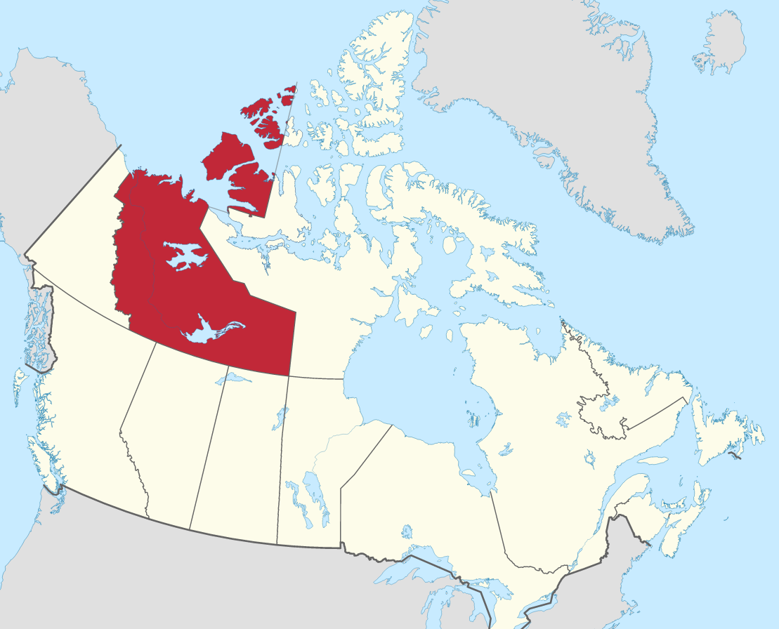
The Northwest Territories is located in northern and northwestern Canada. For much of the 20th century, this region was more than one-third of Canada’s total land area. It stretched from the east to the west across North America’s roof. In 1999, Nunavut was created out of the eastern section of the Northwest Territories and reduced its size by more than half.
The Northwest Territories are at the northernmost part of Canada, bordering Nunavut to the east and Yukon to the west. The provinces of Alberta, Saskatchewan, and British Columbia are located in the south, while Nunavut borders the territories in the north. This territory covers around 1,346,106 square km / 519,735 square miles. The capital is Yellowknife, and it has a population of 41,070 people.
Principal cities and towns
Yellowknife, Inuvik, Hay River, Fort Smith.
History
Icelandic traders likely visited parts of Canada in the Middle Ages. Still, records indicate that exploration didn’t happen until Martin Frobisher’s voyage in search of the Northwest Passage to the east in 1576. Expeditions in the 17th century also failed to find the route, but they added knowledge to Arctic regions. Interest in finding the route waned in the 18th century, but whaling ships became abundant in Arctic waters as time passed. The first recorded exploration of American territory was by Samuel Hearne, who traveled from the west coast of Hudson Bay to the mouth of the Coppermine River on the northern coast between 1770-1772. In addition, Montreal-based fur traders did most inland explorations. Others like Alexander Mackenzie explored; he traveled down river bearing his name and reached the Arctic Ocean in 1789.
Throughout the 19th century, people across Canada, Europe, and the USA were looking for a Northwest Passage. Sir John Franklin and other explorers discovered much of Mackenzie District in what is now Northern Canada (Fort Smith & Inuvik) during the 1820s. In 1838–1839, explorer Thomas Simpson explored more parts of Northern Canada while searching for the lost Franklin expedition of 1845–1848. Other expeditions followed this groundbreaking work to the Arctic, who were trying to reach the North Pole, such as Robert Gary Jack (1913), Roald Amundsen (1926), and Richard E. Byrd (1930). However, more practical activities overshadowed these exploits, such as identifying the resource potential of Canadian National Parks in the 1920s-1960s, which began to transform this vast wilderness into a valuable national family heirloom.
Geography
Northern Canada borders two of Canada’s other territories, Yukon to the west and Nunavut to the east, and four provinces: British Columbia, Alberta, Saskatchewan, and Manitoba. The territory has a land area of 1,183,085 sq kilometer / 456,792 sq mi.
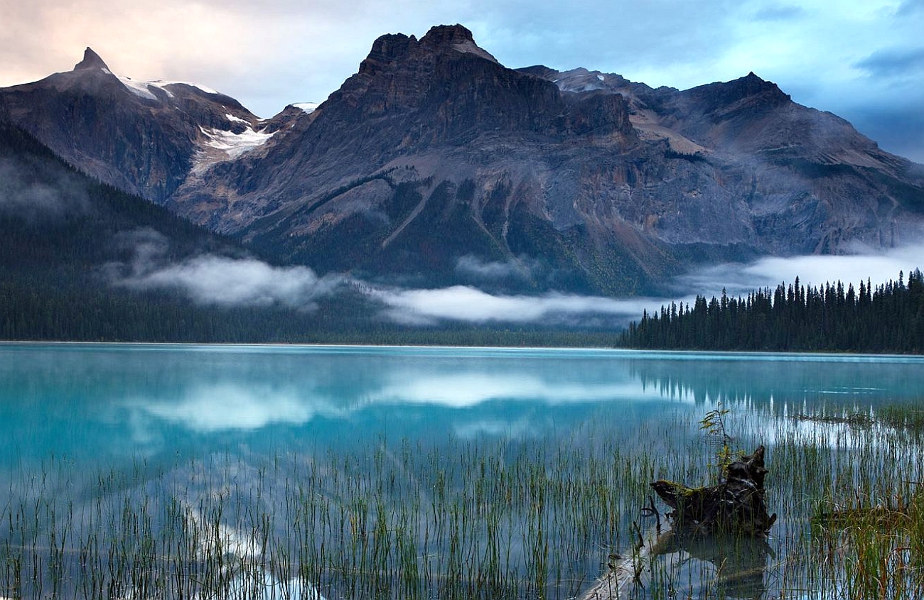
There are two main types of landscape represented in the Yukon region. First, the boreal forest borders the northernmost part of the province and is roughly parallel to the border with Nunavut. The second landscape type extends westward from near the Mackenzie River Delta on the Arctic Ocean to northwestern Manitoba. Southwest of this line lies flat, poorly drained plains underlain by rock 1 billion years old or more in Eastern Canada. North and east of that point stretch out largely barren grounds, with terrain becoming increasingly varied moving westward.
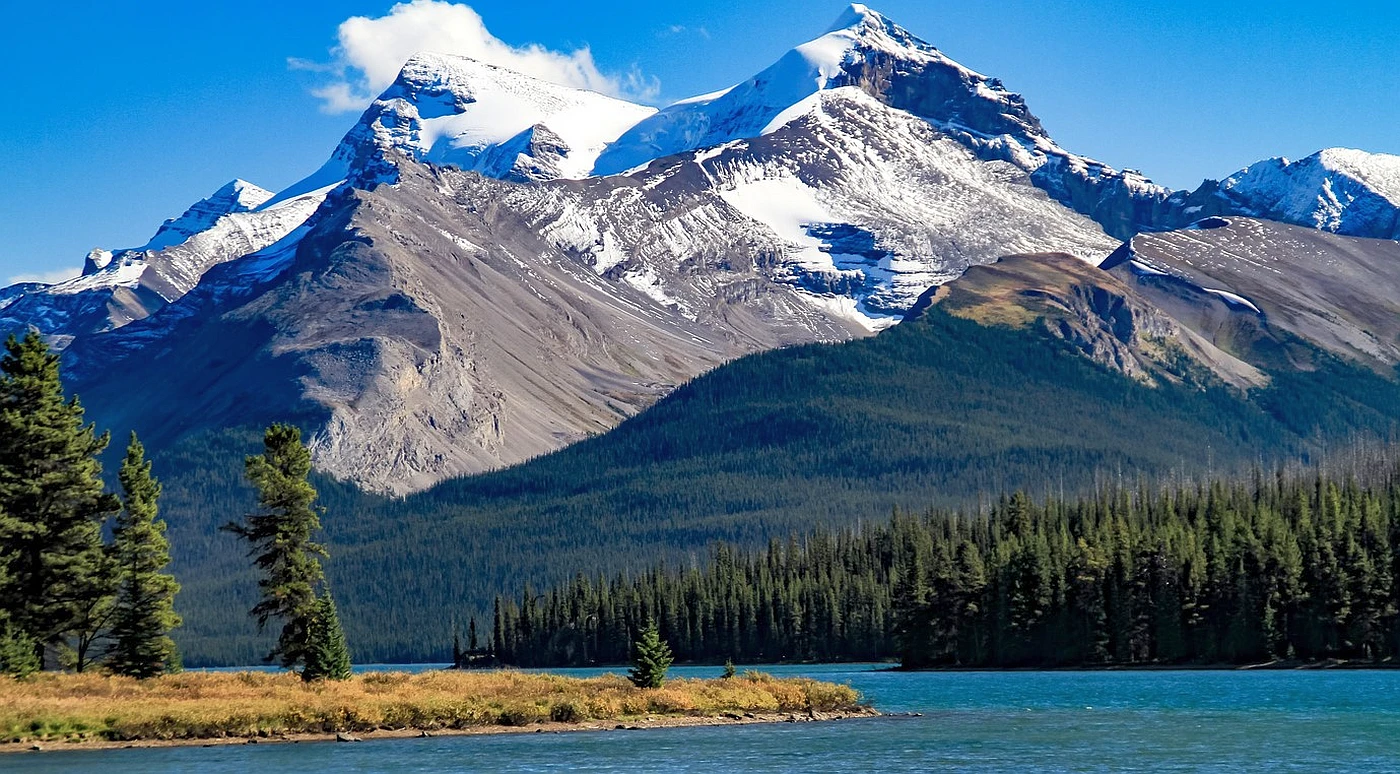
The Mackenzie Mountains in the west and southwest contain the highest and most rugged relief in the territories; elevations reach 2,773 meters / 9,098 feet at an unnamed peak near Mount Sir James MacBrien itself, 2,762 meters / 9,062 feet. In addition, even in these regions, there are enormous differences in surface vegetation and animal life due to climatic restrictions.
Climate
The Northwest Territories extends for more than 1,300,000 km2 / 500,000 sq mi) and has a large climate variant from south to north. The southern part of the territory (most of the mainland portion) has a subarctic climate, while the islands and northern coast have a polar climate.
In the Mackenzie Lowlands, it’s usually pretty warm and dry in the summer and cold and long in the winter. During the summer, the average temperature is often 16 °C / 60 °F at most settlements along the Mackenzie River. In the winter, Yellowknife averages −27 °C / –16 °F. It’s cold year-round North and east of the timberline, with an average temperature of 10 °C / 50 °F even in July. The climate stays mild throughout “average” years.
Google Maps Northwest Territories
Please click here for driving directions.
Did you know?
- The Native American Indian population is more than one-third of the territorial population, comprising the Dene and the Métis.
- The Dene are concentrated in the Mackenzie Valley area of Canada. They belong to several different tribes belonging to the Athabaskan language family.
- Government treaties were made with the groups living south of Great Slave Lake in 1899 and those living farther north only in 1921.
- The Inuit constitute a little over 1% of Canada’s population. They live mainly in the northern coastal areas, especially Nunavut, Northwest Territories, and Yukon.
- The indigenous tribes of the territory once had a nomadic way of life; the Inuit, in particular, survived by adjusting to the harsh natural environment. That balance was disrupted when Europeans established permanent settlements with firearms and destroyed the habitat, which led to a dwindling food supply and continued social unrest.
- In 1877, the territorial government made French an official language. After a long and heated debate about this, the members in 1888 voted for French to no longer be an official language. A few conflicts with the Canadian government wanting to make French the only language led to a decisive vote on January 19, 1892. The members of Parliament voted in favor of English being the only language used in Parliament.
- The census in 2021 shows that Christianity had over 50% of the population, down from 67% in 2001.
What to do in the Northwest Territories
There is no shortage of outdoor activities and sights to see in the Northwest Territories. There is something for everyone, from hiking and camping in the many national parks to fishing and canoeing in the pristine lakes and rivers.
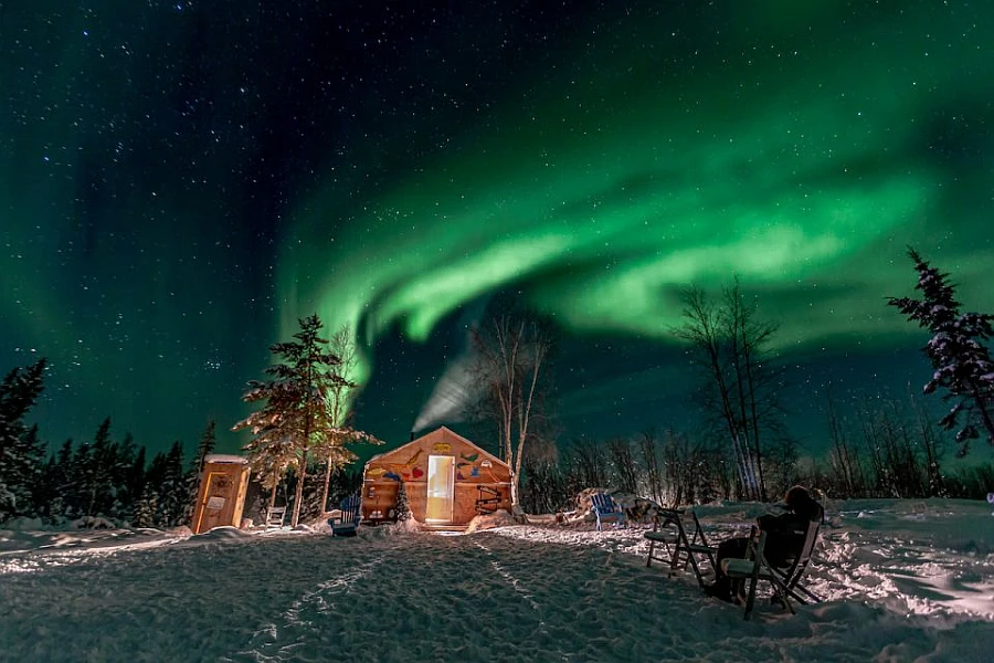
For those who love to hike, there are plenty of trails to explore, ranging from easy walks to more challenging climbs. For those who prefer to spend their time on the water, there are endless opportunities for fishing, canoeing, and kayaking. And for those who want to experience the true beauty of the north, there are a variety of tours and safaris that will take you deep into the wilderness. Aurora Borealis Evening Viewing Tours, Nighttime Northern Lights Viewing, Rocky Mountains Helicopter Tour, and Kluane National Parks are some of the most popular activities.
The absolute top attractions and activities in Northwest Territories, as travelers vote, are Enjoying the simple life in a rural lodge, Falling in love under the midnight sun, Glittering waterfalls, Fishing, Cruising in the historic waterways, Meeting with caribous and Moses, visiting the Nahanni National Park Reserve, Shooting in the wild, Taking a dip in Canada’s watersports scene, Visiting the city of Yellowknife, Walking the Northwest’s hiking trails, Wondering at the Arctic coastline.
Whatever your interests may be, there is sure to be an outdoor activity or sight that will appeal to you in the Northwest Territories. So come and explore all that this amazing place has to offer!
Accommodation in the Northwest Territories
A wide range of accommodation options is available in the Northwest Territories, from hotels and B&Bs to self-contained rooms and apartments. There is something to suit all budgets and preferences, so you can be sure to find the perfect place to stay during your time in the territory. Whether you’re looking for a luxurious hotel or a cozy B&B, you’ll be able to find it in the Northwest Territories.
Reserve a room
Our tip for accommodation in the Northwest Territories would be to consider staying in a traditional Indigenous community or a wilderness lodge. The Northwest Territories is home to many Indigenous communities, and staying in one of these communities can provide a unique and authentic cultural experience. Many communities have guesthouses or bed and breakfasts that offer comfortable and affordable accommodation. Additionally, the Northwest Territories is known for its rugged wilderness, and staying in a wilderness lodge can provide an opportunity to experience the region’s natural beauty. Many lodges offer all-inclusive packages that include meals, activities, and transportation to and from the lodge.
Pictures
Useful information
Best time to visit: The Northwest Territories’ climate is cold but relatively dry, with temperate, sunny summers, in which temperatures rarely rise above 25°C / 77°F, and long, bitter winters, during which the thermometer can plunge to -40°C / -40°F, especially north of the Arctic Circle.
On the road: Northwest Territories has nine numbered highways. The Mackenzie Highway is the longest, stretching from Alberta Highway 35 to Wrigley in the north. Ice and winter roads also play a major part in life here, providing access to towns and mines during winter. Yellowknife Highway branches out from Mackenzie Highway and connects it to Yellowknife. The Dempster Highway starts just outside Dawson City, Yukon, and continues east for over 700 km (400 mi) to Inuvik. As of 2017, the all-season Inuvik-Tuktoyaktuk Highway connects Inuvik to communities along the Arctic Ocean as an extension of the Dempster Highway.
Yellowknife didn’t have all-season access to the rest of Canada’s highway system until the completion of the Deh Cho Bridge in 2012. Before this, traffic relied on a ferry service in summer and an ice road in winter. This became a problem during autumn when the ice wasn’t thick enough for cars, but the ferry couldn’t get through it, requiring everything from petrol to groceries to be airlifted for that transition period.
Air travel: To reach the more remote areas in our territory, we’ve found that an airplane is typically the best way to travel. Float planes are the most common plane used to reach the northern lakes. The three largest operators in the region are Air Canada, First Air, and Canadian North, which fly from Edmonton, Calgary, and Ottawa, respectively. Innumerable regional airlines offer scheduled and charter services to communities within the Northwest Territories.
The Yellowknife Airport is the largest regarding aircraft movements and passengers. It is the gateway to other locations in the Northwest Territories. As the airport of the territory’s capital, it’s a part of Canada’s National Airports System. It hosts multiple regional airlines, notably Buffalo Airways, Canadian North, and North-Wright Airways.
Cruises: Day cruises are offered on Great Slave Lake during the summertime. Longer canoe trips and river rafting trips on the Nahanni River or other more remote rivers are also offered.
Ferry operators: Ideally, tourists could travel on ferries crossing the Mackenzie River for free during summer. Unfortunately, these are unavailable during winter, so ice bridges are employed during these times instead. Spring and autumn are our least favorite seasons because attendees will have difficulty crossing the rivers without a ferry – though you can reach out to 1 800 661 0750 for more information about routes if need be.
Public transportation: Yellowknife Transit is the only public transit system in the Northwest Territories.
You may also be interested in
- Alberta
- British Columbia
- Manitoba
- New Brunswick
- Newfoundland and Labrador
- Northwest Territories
- Nova Scotia
- Nunavut
- Ontario
- Prince Edward Island
- Quebec
- Saskatchewan
- Yukon
Did you like this Northwest Territories map and information page? Please don‘t forget to share or bookmark this content on Canada Maps.com!