Newfoundland and Labrador

Home » Newfoundland and Labrador

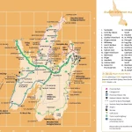
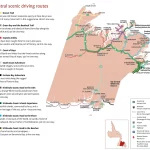
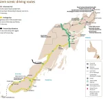
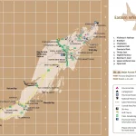
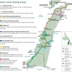
Where is Newfoundland and Labrador?

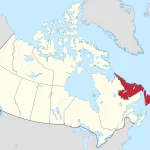
Nestled on the easternmost edge of North America, Newfoundland and Labrador is a province that boasts stunning natural beauty. This rugged land is made up of two main regions: the island of Newfoundland and the mainland portion known as Labrador.

Home » Newfoundland and Labrador

Explore the Best of Labrador with Scenic Driving Routes

Labrador is a vast and breathtaking region in Canada, known for its rugged natural beauty, diverse wildlife, and fascinating cultural heritage. To explore this stunning destination, there’s no better way than hitting the open road and embarking on a scenic driving adventure. That’s where our Labrador Scenic Driving Routes Map comes in, helping you navigate … Read more

Home » Newfoundland and Labrador

Explore the Beauty of Central Newfoundland with this Tourist Map

This map shows cities, towns, the Trans-Canada highway, secondary roads, national parks, provincial parks, campgrounds, provincial/national historic sites, airports, local ferries, summer ferries, ski areas, golf courses, and provincial visitor information centers in Central Newfoundland.

Home » Newfoundland and Labrador

Experience the Best of Avalon with Scenic Driving Routes Map

This map shows cities, towns, trails, Trans-Canada highways, secondary roads, national parks, provincial parks, provincial visitor information centers, provincial/national historic sites, ferries, airports, and natural scenic attractions in Avalon.

Home » Newfoundland and Labrador

Discovering Avalon: A Tourist Map Guide for Exploring Canada’s Eastern Coast

This map shows cities, towns, Trans-Canada highways, secondary roads, national parks, provincial parks, campgrounds, provincial/national historic sites, airports, local ferries, summer ferries, ski areas, golf courses, and provincial visitor information centers in Avalon.

Home » Newfoundland and Labrador

Discover Central Newfoundland’s Scenic Beauty with our Driving Routes Map

This map shows cities, towns, trails, Trans-Canada highways, secondary roads, national parks, provincial parks, provincial visitor information centers, provincial/national historic sites, ferries, airports, and natural scenic attractions in Central Newfoundland.

Home » Newfoundland and Labrador

Discover Eastern Newfoundland’s Natural Beauty with this Scenic Driving Route Map

This map shows cities, towns, trails, Trans-Canada highways, secondary roads, national parks, provincial parks, provincial visitor information centers, provincial/national historic sites, ferries, airports, and natural scenic attractions in Eastern Newfoundland.

Home » Newfoundland and Labrador

Explore Eastern Newfoundland with a Comprehensive Tourist Map

This map shows cities, towns, the Trans-Canada highway, secondary roads, national parks, provincial parks, campgrounds, provincial/national historic sites, airports, local ferries, summer ferries, ski areas, golf courses, and provincial visitor information centers in Eastern Newfoundland.

Home » Newfoundland and Labrador

Discover the Beauty of Western Newfoundland with Scenic Driving Routes

This map shows cities, towns, trails, Trans-Canada highways, secondary roads, national parks, provincial parks, provincial visitor information centers, provincial/national historic sites, ferries, airports, and natural scenic attractions in Western Newfoundland.