Eastern Canada has breathtaking natural beauty, bustling cities, and charming small towns. To help visitors navigate this diverse and expansive landscape, Canada Maps has created a comprehensive map that shows not only the provinces, cities, and towns but also the highways, roads, railways, ferry routes, and national parks of Eastern Canada.
What are Such Maps Used for?
This map is an essential resource for anyone planning a road trip, exploring new regions of Eastern Canada, or researching the area’s geography and transportation infrastructure. It provides a clear and comprehensive overview of the various cities and towns across Eastern Canada and the roads, railways, and ferry routes that connect them.
Map of Eastern Canada
This map shows provinces, cities, towns, highways, roads, railways, ferry routes, and national parks in Eastern Canada.
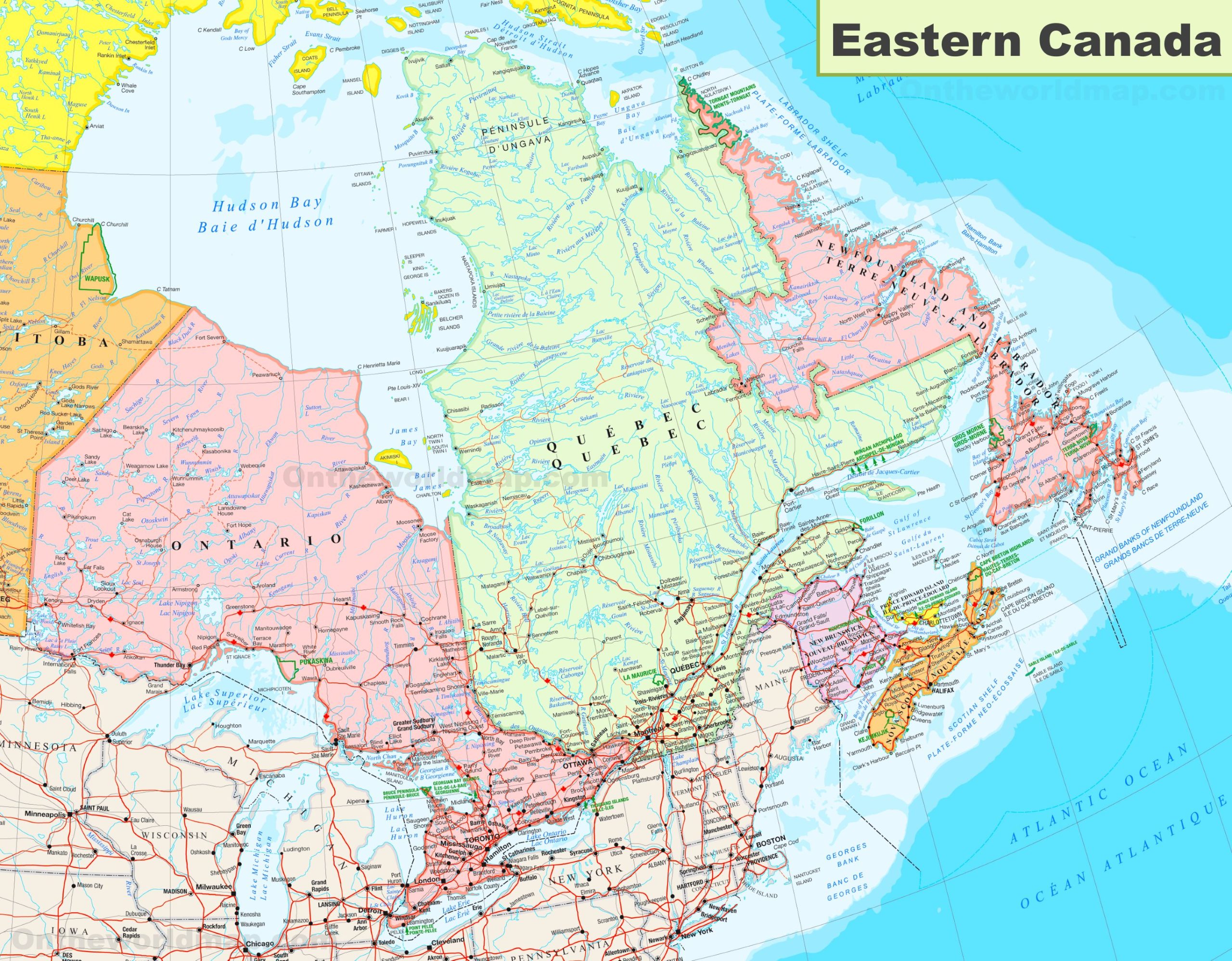
The map of Eastern Canada, with dimensions of 1024 by 799 pixels, provides a detailed view of this culturally rich and historically significant region. It encompasses the provinces of Ontario, Quebec, New Brunswick, Prince Edward Island, Nova Scotia, Newfoundland and Labrador, and parts of northern Canada.
This map includes major cities such as Toronto, Montreal, Ottawa, Quebec City, and Halifax, which are the region’s key cultural and economic centers. It also features the diverse landscapes of Eastern Canada, from the Great Lakes and the St. Lawrence River to the Appalachian Mountains and the rugged Atlantic coastline.
Key highways and transportation routes are marked, facilitating regional travel and trade. The map also highlights natural landmarks and tourist attractions, such as Niagara Falls, the Cabot Trail, and the historic sites of Old Quebec, which are significant draws for visitors.
Eastern Canada’s economy is diverse, with a mix of manufacturing, technology, and natural resources, including fisheries and forestry, which would be indicated by the presence of related infrastructure on the map. The region’s cultural diversity, with a strong presence of French-Canadian, Anglophone, and Indigenous communities, adds to the rich tapestry that makes up Eastern Canada’s identity.
For travelers and residents alike, this map is a valuable resource for navigating the region’s vast distances and discovering the many attractions that Eastern Canada offers.
Did You Know About Canada?
Eastern Canada, steeped in natural beauty and historical significance, is a region that offers a tapestry of experiences for visitors.
The national parks of Eastern Canada, such as Fundy, Gros Morne, and Cape Breton Highlands, are natural sanctuaries that showcase the diverse ecosystems of the region. Fundy National Park in New Brunswick is famous for having the highest tides in the world, creating unique coastal landscapes that change dramatically throughout the day. Gros Morne National Park in Newfoundland and Labrador is a UNESCO World Heritage Site, celebrated for its complex geology and dramatic fjord landscapes. Cape Breton Highlands National Park in Nova Scotia is known for its spectacular highland scenery and the famous Cabot Trail, which offers some of North America’s most stunning coastal drives.
These parks are not just havens for outdoor enthusiasts but also critical habitats for various wildlife, including moose, black bears, and numerous bird species. They offer a range of activities, from hiking and camping to whale watching and kayaking, allowing visitors to immerse themselves in the natural splendor of Eastern Canada.
The historic cities of Eastern Canada are treasure troves of culture. With its fortified colonial core, Quebec City is one of North America’s oldest and most beautiful cities, offering a slice of European charm. Montreal, a city known for its festivals and arts scene, is a melting pot of cultures and one of the world’s great bilingual cities. With its maritime heritage, Halifax is a city that blends history with a youthful energy, home to the historic waterfront and the Canadian Museum of Immigration at Pier 21.
Beyond the bustling cities, the small towns and villages of Eastern Canada are the heart of the region’s cultural landscape. They offer a more intimate connection to the local way of life, from the Atlantic coast fishing villages to the French-speaking New Brunswick enclaves. These communities are custodians of the region’s traditions, from the Celtic and Acadian music that fills the air to the storytelling that is an integral part of Newfoundland’s cultural fabric.
Eastern Canada’s economy is as diverse as its geography, with industries ranging from the fisheries of the Maritimes to the aerospace and technology sectors of Quebec and Ontario. The region’s natural resources, including its forests and oceans, have long been the backbone of its economic activity, but there is also a growing focus on innovation and sustainable development.
For visitors, Eastern Canada offers a journey through a region rich in history and natural wonders. It is a place where the past and present merge, where the rhythm of the ocean tides sets the pace of life, and where every corner holds a story waiting to be discovered.
Conclusion
Canada Maps’ map of provinces, cities, towns, highways, roads, railways, ferry routes, and national parks in Eastern Canada is essential for anyone interested in exploring this diverse and beautiful region. Whether planning a road trip, researching different regions of Eastern Canada, or simply curious about the area’s geography, this map provides a clear and comprehensive overview of the region’s natural and urban landscapes.
With its detailed visuals and extensive coverage, this map is an excellent tool for exploring Eastern Canada’s diverse regions, from the rugged coastlines of Newfoundland and Labrador to the vibrant urban communities of Quebec City and Montreal.
Visit this link for more Canada-related maps.