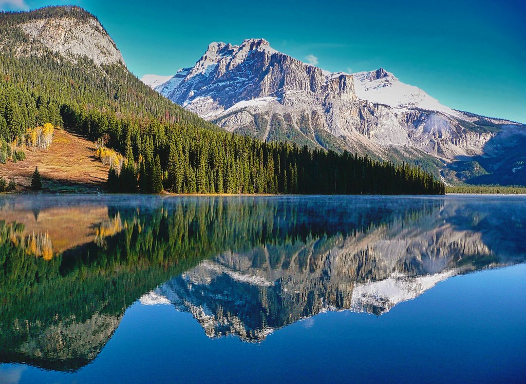
Canada is home to some of the most breathtaking natural landscapes in the world, and its national parks offer the perfect opportunity for visitors to explore and experience the country’s diverse and varied terrain. From the rugged coastlines of the Pacific Rim National Park Reserve to the rolling hills of the Prince Edward Island National Park, there is something for everyone to enjoy.
Canada’s national parks are a treasure trove of natural beauty and ecological diversity. Protected under the Canada National Parks Act, these areas are owned by the Government of Canada. They are managed by Parks Canada, a Crown agency operating under the jurisdiction of the Ministry of Environment and Climate Change. The goal of the national parks system is to preserve and protect Canada’s 39 distinct natural regions while also providing opportunities for the public to explore, learn about, and enjoy these natural spaces.
Canada’s first national park, established in 1885, was the Cave and Basin Hot Springs. This was followed by the creation of Banff National Park in 1887, modeled after the American experience with Yellowstone National Park. Over the years, many more national parks have been established to preserve and protect the country’s natural heritage for future generations.
Today, there are 38 national parks, 10 national park reserves, and one national urban park, covering an area of approximately 342,456 km2, or about 3.3% of Canada’s total land area. These parks represent 31 of the country’s 39 natural regions and can be found in all of Canada’s 13 provinces and territories. With over 15 million visitors annually, these parks are a popular destination for nature lovers, hikers, and outdoor enthusiasts.
However, it is important to note that the early national parks, including Banff, had an exclusionary policy that prohibited First Nations people from using their traditional lands within the new parks.
Map of the national parks in Canada: To help visitors plan their trip to Canada’s national parks, we have published a Google map that shows the locations of all the national parks in the country. This map allows visitors to see exactly where each park is located and what attractions and activities are available in the area. Whether you are interested in hiking, fishing, or simply taking in the country’s stunning natural beauty, our map makes it easy to find the perfect national park for your next adventure.
National parks
A national park in Canada is a protected area established and governed by federal legislation to preserve the country’s natural heritage. Each national park is designated to represent a significant natural region as identified in the National Parks System Plan. These parks allow visitors to experience and appreciate Canada’s diverse and unique landscapes, including mountains, forests, lakes, and coastlines.
National park reserves
A national park reserve in Canada is an area that has been designated to become a national park. Still, the final boundaries and other terms of the park will only be established upon the resolution of an unresolved land claim. Indigenous peoples may continue to use the land for traditional hunting, fishing, and trapping purposes while the land claim is being negotiated between the federal and Indigenous governments. Once the land claim has been resolved, the national park reserve can be formally established and brought under the jurisdiction of the Canadian National Parks Act, which provides the same protections as those for regular national parks.
Parks Canada
Parks Canada is the federal government agency responsible for administering and managing Canada’s national parks system. This organization has a long history dating back to 1911 when it was established as the Dominion Parks Branch, the world’s first national parks service. In 1998, Parks Canada became its own agency and continued to play a crucial role in the preservation and protection of Canada’s natural heritage. Parks Canada is responsible for overseeing the operation and maintenance of national parks, national park reserves, and other protected areas in Canada and promoting public understanding and enjoyment of these areas.
Google Maps of the National Parks of Canada
The Map of National Parks and other recreation areas in Canada is an essential resource for anyone planning a trip to explore the country’s stunning natural landscapes. This map shows the locations of all the national parks in Canada and other recreational areas such as provincial parks, wildlife reserves, and marine conservation areas. With this map, visitors can see exactly where each park is located and what attractions and activities are available in the area. Whether you are interested in hiking, camping, fishing, or simply taking in breathtaking views, this map will help you find the perfect spot to experience Canada’s great outdoors.
The complete list of the national parks in Canada
In addition to the Google map, we have provided a list of all the national parks in Canada, along with brief descriptions of each. This information will help visitors understand what each park has to offer and what they can expect to see and do while there.
Aulavik National Park, Banff National Park, Bruce Peninsula National Park, Cape Breton Highlands National Park, Elk Island National Park, Forillon National Park, Fundy National Park, Georgian Bay Islands National Park, Gros Morne National Park, Gulf Islands National Park, Ivvavik National Park, Jasper National Park, Kejimkujik National Park, Kluane National Park, Kootenay National Park, La Mauricie National Park, Mingan Archipelago National Park, Mount Revelstoke National Park, Nahanni National Park, Point Pelee National Park, Prince Albert National Park, Prince Edward Island National Park, Pukaskwa National Park, Qausuittuq National Park, Quttinirpaaq National Park, Riding Mountain National Park, Rouge National Urban Park, Sable Island National Park, Sirmilik National Park, Terra Nova National Park, Thousand Islands National Park, Torngat Mountains National Park, Tuktut Nogait National Park, Ukkusiksalik National Park, Vuntut National Park, Wapusk National Park, Waterton Lakes National Park, Wood Buffalo National Park, Yoho National Park.
Printable map of the Canadian national parks
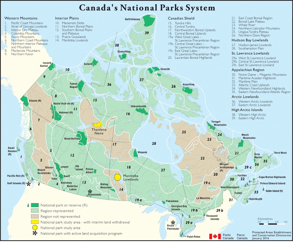
The image is a map titled “National Park Map of Canada,” showcasing Canada’s National Parks System. The map is in JPEG format with dimensions of 1024 pixels in width and 851 pixels in height.
This map provides a detailed overview of Canada’s national parks, reserves, and other protected areas. It includes various regions across Canada, including the Interior Plains, Northern Boreal Plains, Southern Boreal Plains, Western Mountains, Canadian Shield, and more. Each region is marked with specific national parks, reserves, and study areas, providing a comprehensive view of Canada’s efforts in preserving its natural heritage.
Key features of the map include:
- National Parks and Reserves: Marked locations of national parks or reserves (R), indicating areas dedicated to preserving natural landscapes and wildlife.
- Study Areas: Areas marked for national park study, including those with interim land withdrawal, indicating ongoing research and potential future conservation efforts.
- Land Acquisition Programs: Regions where national parks are involved in land acquisition to expand or protect the park areas.
- Geographical Regions: The map categorizes Canada into various geographical regions with unique ecological characteristics and conservation areas.
This map is valuable for understanding the distribution and extent of Canada’s national parks and protected areas. It’s useful for educational purposes, environmental research, and visiting these national treasures.
We hope our map and list of national parks will be a helpful resource for anyone planning a trip to Canada. We encourage all visitors to explore and discover the beauty of Canada’s national parks and respect the natural environment there.