GPS coordinates are numbers corresponding to a specific location on the map. This makes it easy for mapping software and GPS devices to pinpoint a specific spot. Latitude lines run east-west and measure how far north or south of the equator a location is, while longitude lines run north-south and measure how far east or west of the prime meridian a location is. You can usually find GPS coordinates by zooming into a map until you see the little house icon with latitude and longitude data underneath it.
Turn any address into GPS Coordinates
This free tool is a form for entering an address for converting the address into GPS coordinates using a geocoder. When you enter an address in the form and click the “Turn into GPS Coordinates” button, the script requests the geocoder and retrieves the latitude and longitude of the address. The coordinates are then displayed below the button printed in Orange color.
This tool could be helpful for users who need to convert addresses into GPS coordinates for various purposes, such as mapping applications or location-based services. It can be useful for users who don’t have access to a GPS device or who need to quickly get the coordinates for an address without manually looking it up on a map or other tool.
Google Maps with Latitudes & Longitudes
Latitude and longitude can be used to pinpoint a location on a map. To find a location’s latitude and longitude, zoom in on the location on the map, then click on the Google Map below.
The latitude and longitude of the location will be displayed below the map, printed in orange color. You can copy and paste those coordinates into your favorite mapping websites, such as Bing or MapQuest. In case you prefer searching, please use the GPS Coordinate Converter above.
About the Coordinates
Latitude lines are always parallel to the equator, while longitude lines converge at the North and South Poles. Coordinates can be written as either degrees, minutes, and seconds (DMS) or decimal degrees. The coordinates for a specific location on Earth can be determined using a map or GPS device. Once the coordinates are known, they can locate any place on Earth.
Latitude is a measure of location distance, specifically related to the Equator or North Pole. It can be measured in degrees north or south, with each degree being 111 kilometers (69 miles), and it ranges from 0 degrees to 90 degrees. Latitude is how we measure an angle and is used to show a location’s distance from the Equator or the North Pole. For example, at 23 degrees 26 minutes 21 seconds N, latitude is the location that reaches the furthest north where the sun can be seen directly overhead on a solstice.
Longitude is a measurement of the distance of an object to either the North Pole or the South Pole, which are 180 degrees apart. The Prime Meridian – 60 degrees longitude – passes through the Greenwich Observatory in London, England, and is universally accepted as 0 degrees of longitude. However, 360 degrees of longitude are measured across the entire Earth, which intersects meridians to create different grids with varying patterns.
History of the GPS Coordinates
GPS, or Global Positioning System, is a satellite-based navigation system developed by the United States Department of Defense. The military first used it for navigation and targeting purposes, but it has since become widely available to the general public for various uses.
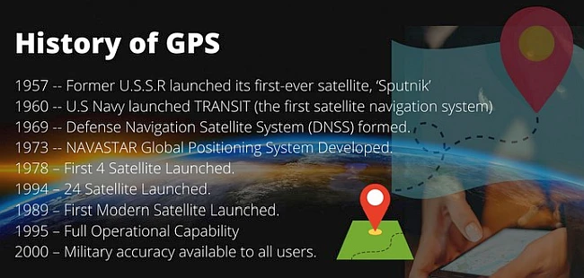
The idea for GPS dates back to the 1950s when the U.S. military began exploring the use of satellites for navigation. In the 1960s, the Department of Defense began testing and developing the technology, and in 1978, the first GPS satellite was launched into orbit.
GPS became fully operational in 1994 when the last 24 satellites in the constellation were launched. These satellites orbit the Earth at an altitude of about 20,000 kilometers / 12,000 miles and transmit signals to receivers on the ground. The receiver uses these signals to determine its position, speed, and altitude and can provide location information with an accuracy of a few meters.
Today, GPS is used in many applications, including navigation in cars, planes, and ships, as well as in military, aviation, and other applications. It is also used in geolocation services, such as mapping and location-based advertising, and various scientific and research applications.