cities

Home » cities » Page 2

Explore the Best of British Columbia: A Detailed Map of Cities, Towns, and Natural Wonders

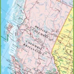
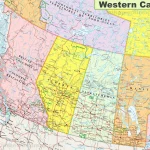
This map shows cities, towns, rivers, lakes, the Trans-Canada highway, major highways, secondary roads, winter roads, railways, and national parks in British Columbia.

Home » cities » Page 2

Discover the Best of Southern Ontario: A Map of Cities, Rivers, and Highways

This map shows cities, towns, rivers, lakes, major roads, minor roads, railways, and Trans-Canada highways in Southern Ontario.

Home » cities » Page 2

Navigate Ontario with Ease: A Map of Highways, Cities, and Points of Interest

This map shows highways in Ontario. Cities, towns, counties, interprovince highways, Canada highways, province highways, main roads, secondary roads, rivers, lakes, airports, national parks, rest areas, welcome centers, Indian reservations, scenic byways, and points of interest in Ontario. Hotels, resorts, beaches, national parks, rest areas, welcome centers, Indian reservations, scenic byways, points of interest, tourist attractions, and sightseeing in Ontario.

Home » cities » Page 2

Explore Eastern Canada’s Natural and Urban Landscapes with Canada Maps

Map of Eastern Canada

This map shows provinces, cities, towns, highways, roads, railways, ferry routes, and national parks in Eastern Canada.

Home » cities » Page 2

Discover Canada’s Cities and Towns with Canada Maps

Map of Canada with cities

This map shows Canada’s provinces, territories, cities, towns, and roads.

Home » cities » Page 2

Discover Canada’s Landscapes and Transportation Networks with Canada Maps

This map shows Canada's provinces, territories, provincial and territorial capitals, cities, towns, highways, roads, trans-Canada highways, railways, and rivers.

This map shows Canada’s provinces, territories, provincial and territorial capitals, cities, towns, highways, roads, trans-Canada highways, railways, and rivers.