Western Canada is a region of unparalleled natural beauty, from the soaring peaks of the Rocky Mountains to the rugged coastlines of British Columbia. To help visitors explore this stunning landscape, Canada Maps has created a comprehensive map that shows not only the provinces, cities, and towns but also the highways, roads, railways, ferry routes, and national parks of Western Canada.
What are Such Maps Used for?
This map is an essential resource for anyone planning a road trip, exploring new regions of Western Canada, or researching the area’s geography and transportation infrastructure. It provides a clear and comprehensive overview of the various cities and towns across Western Canada, as well as the roads, railways, and ferry routes that connect them.
Map of Western Canada
This map shows provinces, cities, towns, highways, roads, railways, ferry routes, and national parks in Western Canada.
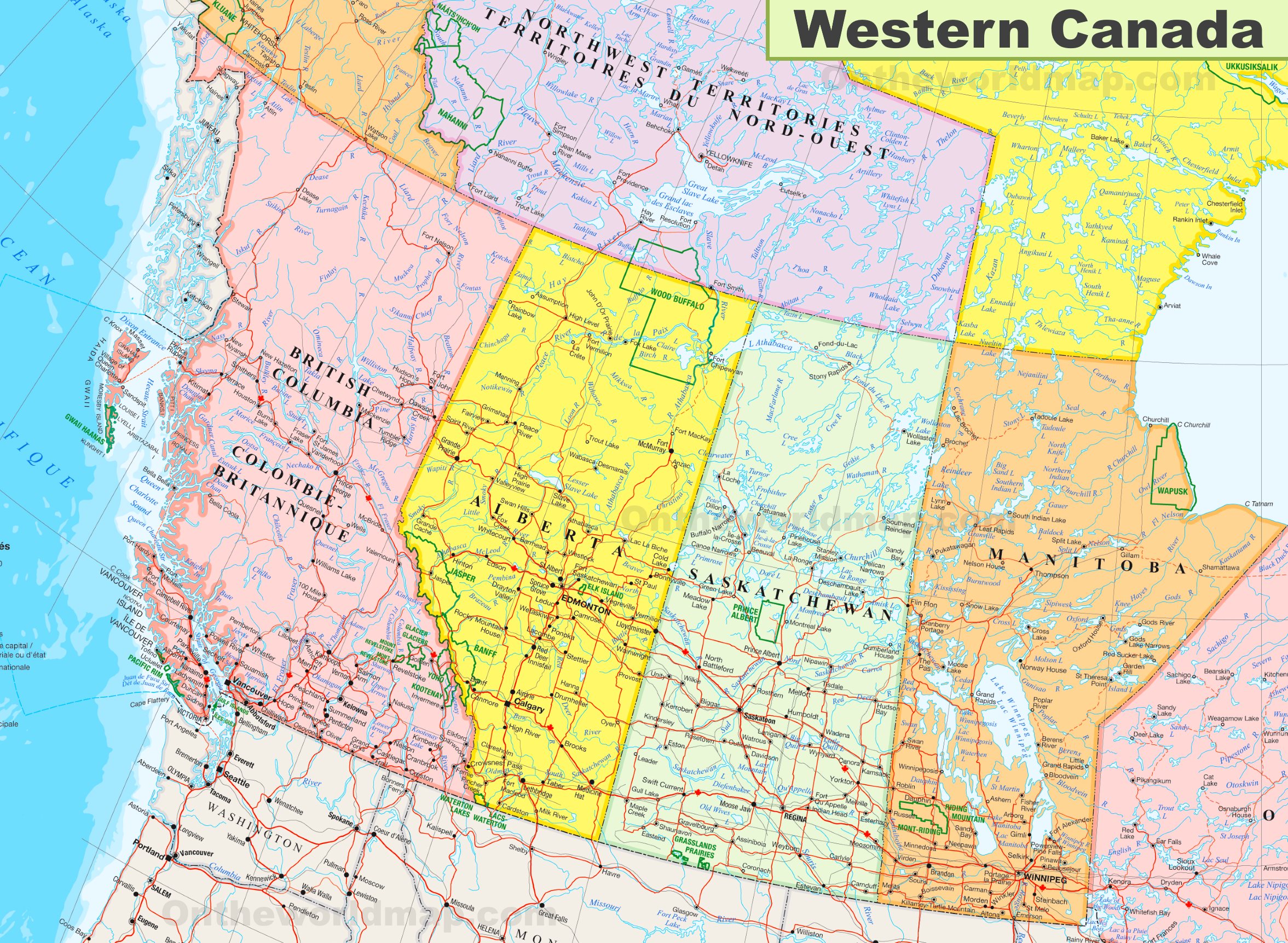
The map of Western Canada, with dimensions of 2353 by 1723 pixels, offers a detailed representation of this expansive region. It encompasses the provinces of British Columbia, Alberta, Saskatchewan, and Manitoba, as well as the northern territories of Yukon, Northwest Territories, and parts of Nunavut.
This map includes major cities such as Vancouver, Calgary, Edmonton, Regina, and Winnipeg, serving as urban anchors in a landscape dominated by natural beauty. The map also features the region’s diverse topography, from the Pacific coastline and the mountainous terrain of the Canadian Rockies to the vast prairies and the rugged northern wilderness.
Key highways and transportation routes crisscross the map, providing vital links between the bustling cities and remote communities. Natural landmarks such as national parks, lakes, and rivers are also highlighted, showcasing the region’s rich environmental heritage.
Western Canada is known for its resource-based economy, including forestry, mining, and oil and gas extraction, which is indicated by the presence of related infrastructure on the map. The region’s cultural diversity, with a mix of indigenous communities and a history of immigration, adds to the tapestry that makes up Western Canada’s unique identity.
For travelers and residents alike, this map is a valuable resource for navigating the region’s vast distances and discovering the many attractions that Western Canada has to offer.
Did You Know About Canada?
Western Canada, a region of immense beauty and diversity, is not only celebrated for its majestic national parks but also for its dynamic urban centers and quaint rural communities.
The national parks of Western Canada, such as Banff, Jasper, and Glacier, are jewels in the country’s natural crown. Banff National Park, Canada’s oldest national park, is renowned for its awe-inspiring scenery, wildlife, and the famous Lake Louise, whose emerald waters reflect the surrounding mountains. Jasper National Park, the largest in the Canadian Rockies, offers vast wilderness for hiking, camping, and spotting wildlife in their natural habitat. Glacier National Park, with its ancient forests and alpine meadows, provides a glimpse into the power of ice and time, with glaciers that have shaped the landscape over millennia.
These parks are part of a protected area network that preserves the region’s ecological diversity and offers a sanctuary for species such as grizzly bears, moose, and bald eagles. They also provide a playground for outdoor enthusiasts, with activities ranging from skiing and snowboarding in the winter to mountain biking and kayaking in the summer.
The cities of Western Canada are dynamic hubs of culture and economy. Vancouver, a coastal city with a backdrop of mountains, is known for its environmental initiatives, diverse population, and as a film and television production center. Calgary, with its famous Calgary Stampede, embodies the entrepreneurial spirit and is a gateway to the energy sector. Edmonton, the capital of Alberta, is a cultural nexus with a vibrant arts scene and the largest mall in North America, the West Edmonton Mall.
Beyond the urban centers, the small towns and villages of Western Canada offer a glimpse into the region’s soul. Places like Canmore in Alberta or Nelson in British Columbia provide a more intimate experience of the local culture and landscape. These communities often serve as gateways to outdoor adventures and are rich in local history, from the gold rush era to the pioneering days of the Canadian Pacific Railway.
Western Canada’s economy is as varied as its landscape, with industries ranging from agriculture and fishing to technology and renewable energy. The region’s natural resources, including forests, oil, and natural gas, have historically driven economic growth, but there is a growing shift towards sustainability and innovation.
Culturally, Western Canada is a tapestry woven from the traditions of the First Nations people, the spirit of the early settlers, and the customs of recent immigrants. This cultural richness is expressed in the region’s art, festivals, and food, immersing visitors in a vibrant cultural mosaic.
For those looking to explore Western Canada, the journey offers more than just scenic beauty; it is an opportunity to experience the heartbeat of a region with much to offer, from the peaks of its mountains to the depth of its cultural roots.
Conclusion
Canada Maps’ map of provinces, cities, towns, highways, roads, railways, ferry routes, and national parks in Western Canada is essential for anyone interested in exploring this diverse and beautiful region. Whether planning a road trip, researching different regions of Western Canada, or simply curious about the area’s geography, this map provides a clear and comprehensive overview of the region’s natural and urban landscapes.
With its detailed visuals and extensive coverage, this map is an excellent tool for exploring Western Canada’s diverse regions, from the majestic peaks of the Rocky Mountains to the vibrant urban communities of Vancouver and Calgary.
Are you a fan of maps? Check the maps category by Canada Maps!