Home »

Discover Saskatchewan with the Ultimate Tourist Map
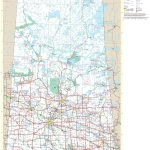
This map shows cities, towns, rivers, lakes, the Trans-Canada highway, major highways, secondary roads, winter roads, CANAM highway, northern woods, and water routes, the Saskota travel route, veterans memorial highway, red coat trail, Louis riel trail, chief whitecap trail, national parks, provincial parks, historic sites, ecological reserves, Indian reservations, regional parks, campgrounds, airports, ferries, tourism visitor reception centers and rest areas in Saskatchewan.