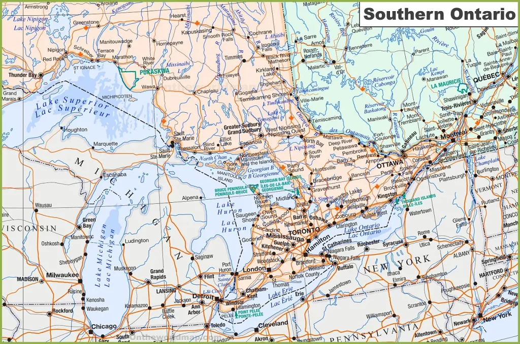
Welcome to CanadaMaps.com, your go-to source for detailed maps of Canada. In this blog post, we’ll be exploring Southern Ontario, a region renowned for its stunning natural beauty, vibrant cities, and charming towns. Our map provides a comprehensive overview of the area, highlighting the key cities, towns, rivers, lakes, and highways that make Southern Ontario a popular destination for tourists and locals alike.
Map of Southern Ontario
This map shows cities, towns, rivers, lakes, major roads, minor roads, railways, and Trans-Canada highways in Southern Ontario.

The map offers a large and detailed view of Southern Ontario, presented at a resolution of 1532×1012 pixels. It meticulously details the region’s cities, towns, and intricate network of roads and highways. The map includes significant geographical features such as lakes and rivers, and it also highlights natural attractions and points of interest, making it an invaluable tool for both residents and visitors navigating this densely populated part of Ontario.
Please visit this page for other map resources or Google Maps.
What Are Such Maps Used For?
Maps of Southern Ontario are essential for anyone traveling within the region, providing valuable information about the area’s key cities, towns, and natural features. This map of Southern Ontario is a must-have resource for anyone planning a road trip or visiting the region, as it shows the area’s major roads, minor roads, Trans-Canada highways, and railways. It also highlights the location of several rivers, lakes, and points of interest, making it easy for visitors to plan they’re itinerary and explore the area.
Did You Know About Canada?
Southern Ontario is home to several major cities, including Toronto, Hamilton, and London, as well as several smaller towns and communities popular with tourists. The map shows the location of these cities and towns, along with several natural features, including rivers and lakes, that are perfect for boating, fishing, and swimming. It also highlights several points of interest, including historic sites and landmarks, making it easy for visitors to explore the region’s rich history and culture.
In addition to its vibrant cities and charming towns, Southern Ontario is home to several natural attractions, including the Niagara Escarpment, Algonquin Provincial Park, and several conservation areas. The map shows the location of these natural features and several scenic routes and trails, making it easy for visitors to explore the stunning landscapes and enjoy outdoor activities.
Conclusion
In conclusion, this map of Southern Ontario is an essential tool for anyone planning a trip to the region. It provides visitors with valuable information about the area’s key cities, towns, and natural features, making navigating and planning their trip easy. Whether exploring the region’s vibrant cities, taking in its stunning natural beauty, or immersing yourself in its rich history and culture, this map will help you make the most of your time in Southern Ontario.