Canada is the second-largest country in the world, and with a land area of over 9.9 million square kilometers, it’s no wonder that navigating the country can be a daunting task. Fortunately, a map can be an invaluable tool in helping to navigate Canada’s vast expanse. In this post, we will look at a map of Canadian cities, roads, and railroads and explore the benefits of using such a map when exploring Canada.
Canada road map
This map shows cities, roads, and railroads in Canada.
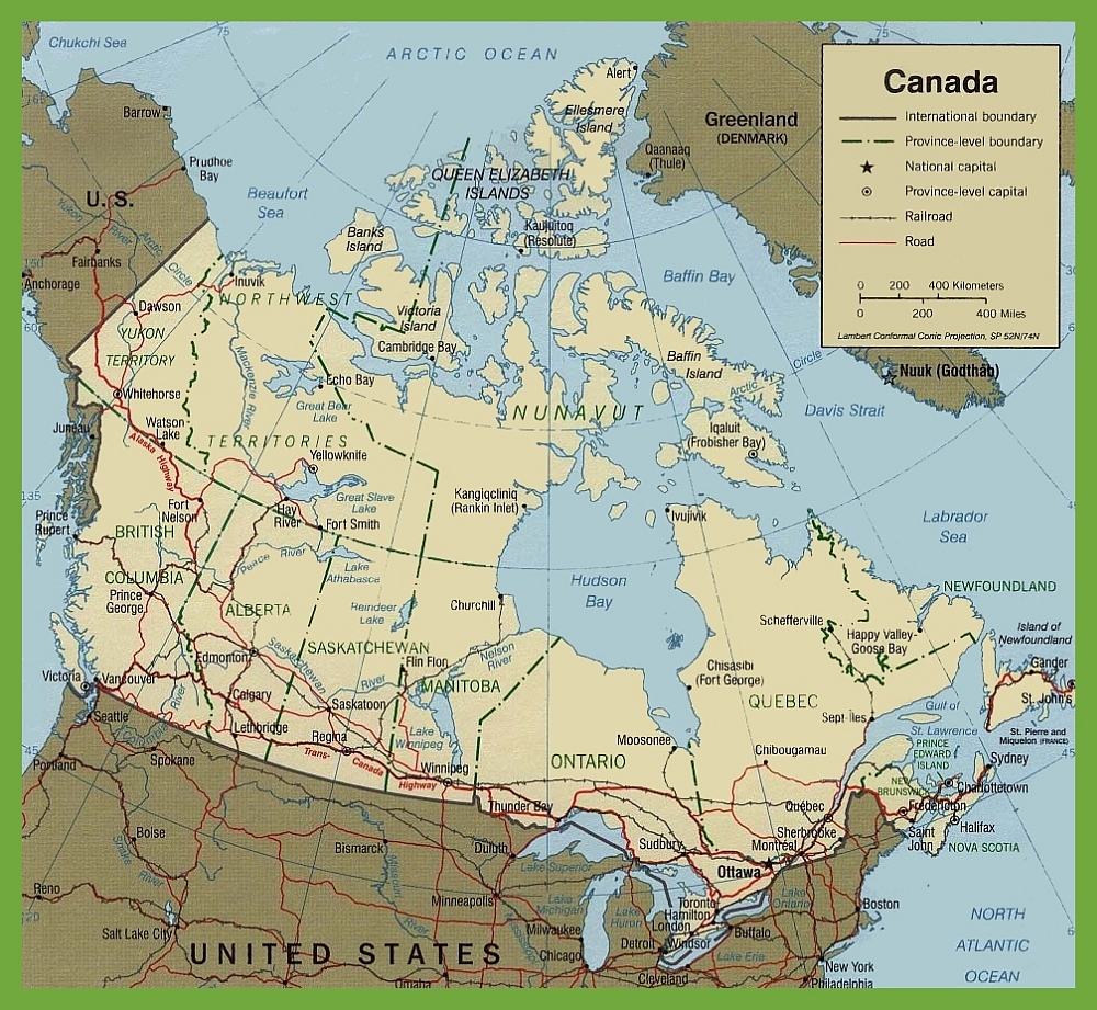
The Canada road map provides a broad overview of the country’s extensive road network, connecting its vast and diverse landscapes. With dimensions of 1000 by 921 pixels, the map is a useful resource for understanding Canada’s geographical layout and transportation infrastructure.
The map includes major national highways that span the country, provincial boundaries, and the international boundary. It also marks the national capital, Ottawa, and provincial and territorial capitals, providing a clear picture of Canada’s political geography.
Railroad lines are indicated, showing rail transport’s critical role in connecting Canadian cities and towns. The map’s scale is given in both kilometers and miles, catering to a wide audience and facilitating distance measurement for trip planning.
This map is a valuable tool for anyone interested in the scope of Canada’s roadways, from coast to coast, including the remote northern regions where roads are fewer but no less important.
What are Canadian maps of cities, roads, and railroads used for?
A map of Canadian cities, roads, and railroads can be used for various purposes, from navigating the country’s highways and byways to planning a road trip. Whether you’re a tourist exploring the country for the first time or a seasoned traveler looking to experience Canada’s many wonders, a map of Canadian cities, roads, and railroads can help you get where you need to go.
Planning a road trip:
One of the most popular uses of a map of Canadian cities, roads, and railroads is for planning a road trip. Canada is home to some of the most beautiful landscapes in the world, and a road trip is an excellent way to see them. A map can help you plan your route so you don’t miss any must-see destinations, and it can also help you find the best routes to avoid traffic or construction.
Navigating Canadian highways and byways:
Navigating Canadian highways and byways can be challenging, especially if you are unfamiliar with the area. A map of Canadian cities, roads, and railroads can help you find the best routes and alert you to any potential hazards or construction zones along the way.
Exploring Canadian cities:
Canada’s urban centers are a tapestry of cultural diversity, natural beauty, and historical significance, each offering a unique experience. A comprehensive map of Canadian cities, roads, and railroads is an indispensable tool for any traveler seeking to explore the country’s breadth of experiences.
Toronto, Canada’s largest city, is a bustling metropolis known for its iconic skyline, which includes the CN Tower, one of the world’s tallest free-standing structures. The city’s diverse neighborhoods, from the historic Distillery District to the eclectic Kensington Market, are a testament to its cultural mosaic.
Montreal, in the province of Quebec, offers a slice of European charm with its cobblestone streets and French-speaking populace. The city is famous for its culinary scene, arts, and the annual Jazz Festival, which attracts music lovers worldwide.
Vancouver, set against the Pacific Ocean and the Coast Mountains backdrop, is a haven for outdoor enthusiasts. Its mild climate and proximity to nature make it ideal for year-round activities, from skiing in Whistler to kayaking in the Strait of Georgia.
The capital city of Ottawa showcases Canada’s rich history and political life. With its Gothic revival architecture, Parliament Hill stands as a symbol of the nation’s governance, while the city’s museums and galleries chronicle Canada’s cultural heritage.
Calgary, known for the Calgary Stampede, offers a unique blend of the modern and the traditional, embodying the spirit of the West with its rodeos and burgeoning arts scene.
A map detailing the roads and railroads connects these urban hubs to lesser-known gems, such as the maritime charm of Halifax or the Francophone culture of Quebec City. The Trans-Canada Highway and VIA Rail provide routes that span the country, offering scenic journeys through the Rockies, prairies, and the rugged landscapes of the Canadian Shield.
For those venturing into the northern territories, cities like Whitehorse in the Yukon offer a gateway to the wilderness of the Arctic, with the Northern Lights dancing overhead.
Whether you’re planning a cross-country road trip, a city-hopping rail journey, or exploring a single destination, a detailed map will guide you through Canada’s cities and the stories they hold, ensuring a rich and rewarding travel experience.
Did you know about Canada?
- Canada’s geography is as vast as it is varied, offering a tapestry of landscapes that are rich in natural beauty and ripe for exploration.
- The country’s coastline, the longest in the world, stretches over 202,080 kilometers, touching three oceans: the Atlantic, Pacific, and Arctic. This extensive coastline is dotted with picturesque lighthouses, rugged cliffs, sandy beaches, and vibrant coastal communities. The coastal waters are a haven for marine life, including whales, seals, and countless species of fish and birds, making it a prime location for wildlife watching and maritime adventures.
- Inland, Canada’s reputation as the land of lakes is well-earned, with over 3 million lakes that cover approximately 9% of its landmass. These lakes are not only a source of natural beauty but also provide habitats for a diverse range of wildlife. They are a playground for water sports, fishing, and leisure activities. Among these, the Great Lakes, which Canada shares with the United States, are the largest group of freshwater lakes on Earth by total area.
- The Canadian Rockies, part of the North American Rocky Mountains, are renowned for their rugged peaks and serene beauty. They offer some of the most breathtaking scenery in the world, with turquoise lakes, snow-capped mountains, and glaciers. This region is a paradise for outdoor enthusiasts, offering world-class hiking, skiing, and mountain biking.
- The world’s largest beaver dam, located in Northern Alberta, is a testament to the industriousness of Canada’s national animal. This remarkable structure, visible from space, exemplifies the beaver’s ecological role as a builder and engineer, shaping the landscape and creating wetlands that support diverse ecosystems.
- Canada’s ten provinces and three territories each contribute a unique thread to the nation’s cultural tapestry. From the French-speaking province of Quebec, with its rich history and distinct cultural identity, to the multicultural vibrancy of Ontario, from the prairie heartland of Saskatchewan to the rugged natural beauty of Newfoundland and Labrador, each region has its own story.
- The territories of the North—Yukon, Northwest Territories, and Nunavut—offer some of the most remote and pristine wilderness areas in the world, with indigenous cultures that have thrived for thousands of years.
- Canada’s history is reflected in its many historical sites and cultural institutions, from the totem poles of British Columbia that tell the stories of the First Nations people to the historical sites of Old Quebec, which echo the colonial past. The country’s traditions are celebrated in festivals like the Calgary Stampede, which showcases the cowboy culture of the West, and the Celtic celebrations of Nova Scotia, reflecting the heritage of Scottish settlers.
This rich mosaic of landscapes and cultures makes Canada a country where every visit can offer a new discovery, and every map tells the story of a land shaped by its geography and its people.
Conclusion:
A map of Canadian cities, roads, and railroads can be valuable for exploring Canada’s vast expanse. Whether planning a road trip or just looking to navigate Canada’s cities, a map can help you get where you need to go. With so much to see and do in Canada, a map is essential for anyone exploring this beautiful country.