Canada is a vast and diverse country with ten provinces and three territories, each with its unique culture and geography. Keeping track of the boundaries and capitals can be challenging in many regions. Luckily, Canada Maps is here to help. Our map shows all the governmental boundaries of Canada’s countries, provinces, territories, and provincial and territorial capitals.
What Are Governmental Boundaries?
Governmental boundaries are the lines that define the areas in which different governments have jurisdiction. These boundaries can be based on various factors, including political, cultural, and geographical considerations. Canada has several types of governmental boundaries, including national, provincial, and territorial.
Political map of Canada
This map shows the governmental boundaries of countries, provinces, territories, and provincial and territorial capitals in Canada.
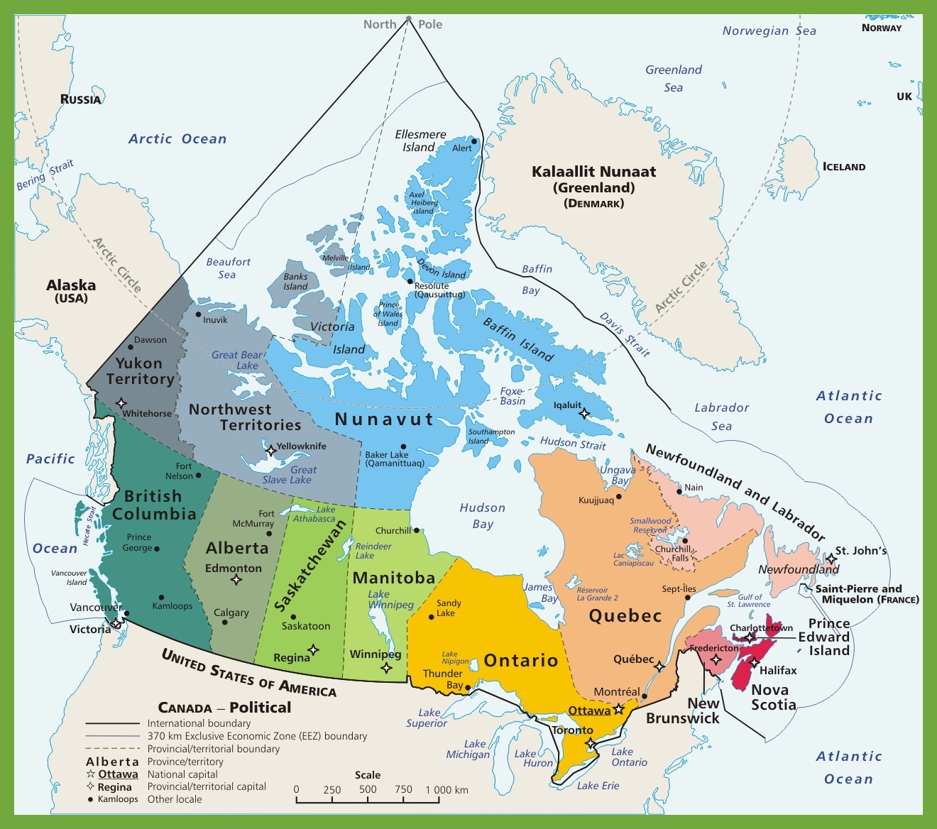
The political map of Canada, measuring 1320 by 1168 pixels, is a comprehensive representation of the country’s political divisions, including provinces and territories, as well as major cities and national capitals. It likely delineates provincial and territorial boundaries and indicates the location of Canada’s capital, Ottawa, along with other significant urban centers like Edmonton, Regina, and Kamloops.
This map would be particularly useful for educational purposes, providing a clear view of Canada’s political landscape. It could also serve travelers and those interested in the political geography of the nation, offering insights into the distribution of power and population across the country.
What Are Such Maps Used For?
Maps that show governmental boundaries are essential tools for anyone interested in understanding a region’s political and geographic landscape. They are used by various people, including government officials, educators, researchers, and tourists.
One of the most significant benefits of using maps that show governmental boundaries is that they provide a clear and concise visual representation of the areas in which different governments have jurisdiction. This can be particularly useful when studying the distribution of resources and the impact of government policies on different regions.
Did You Know About Canada?
Canada’s vast landmass and low population density create a unique blend of expansive wilderness and vibrant urban centers. The country’s geography is as diverse as its people, with landscapes ranging from the Arctic tundra in the north to the temperate rainforests of the west coast, and the rolling prairies in between.
The concentration of the population in urban centers like Toronto, Montreal, and Vancouver has led to a rich tapestry of cultural diversity within these cities. Toronto, often referred to as “the most multicultural city in the world,” is a bustling metropolis where over 140 languages are spoken. Montreal, with its French-speaking majority, offers a slice of Europe with its cobblestone streets and café culture. Vancouver, set against a backdrop of ocean and mountains, is known for its outdoor lifestyle and Pacific Rim influences.
Canada’s bilingual heritage is enshrined in its two official languages, English and French, which are integral to the nation’s identity. The province of Quebec, where French is the predominant language, is the heart of francophone culture in North America. The city of Montreal stands as a beacon of this culture, hosting events like the Just for Laughs festival and the Montreal International Jazz Festival, which draw visitors from around the globe.
The country’s linguistic diversity extends beyond its two official languages, reflecting the heritage of Indigenous peoples and the contributions of immigrants from every corner of the globe. This diversity is celebrated through various festivals, culinary traditions, and artistic expressions that enrich Canada’s cultural landscape.
Canada’s political structure, with its ten provinces and three territories, allows for a degree of regional autonomy that respects the diverse interests and cultures within the country. This structure is reflected in the political map, which shows the boundaries and capitals of these provinces and territories, as well as the federal capital, Ottawa.
For visitors, Canada offers a wealth of experiences, from the natural wonders of Niagara Falls and the Canadian Rockies to the historic sites of Old Quebec and the vibrant arts scene of cities like Toronto. Whether exploring the remote beauty of the Yukon or the bustling streets of downtown Vancouver, Canada’s political map is a guide to a nation of remarkable diversity and beauty.
Conclusion
Canada Maps’ map of governmental boundaries in Canada provides an invaluable tool for anyone interested in understanding the country’s political and geographic landscape. With clear and concise visuals, this map makes it easy to see the areas in which different governments have jurisdiction, including national, provincial, and territorial boundaries.
Whether you’re a government official, educator, researcher, or tourist, this map is essential for understanding the distribution of resources and the impact of government policies on different regions of Canada.