CanadaMaps.com presents a detailed map of Canada using the Vertical Near-Side Perspective Projection, offering a unique view of the country’s topography with precise digital shaded relief. It covers all Canadian and international boundaries, including the historical boundary of Nunavut, established in 1999.
The map also features insets at a 1:35,000,000 scale, illustrating Canada’s physiographic regions, drainage basins, and vegetation. Although the data reflects the mid to late 1990s, it remains a valuable reference for those studying Canada’s geography and political evolution during that time.
This map is a vital tool for researchers, educators, and anyone interested in Canada’s natural and political landscape.
Relief Map of Canada
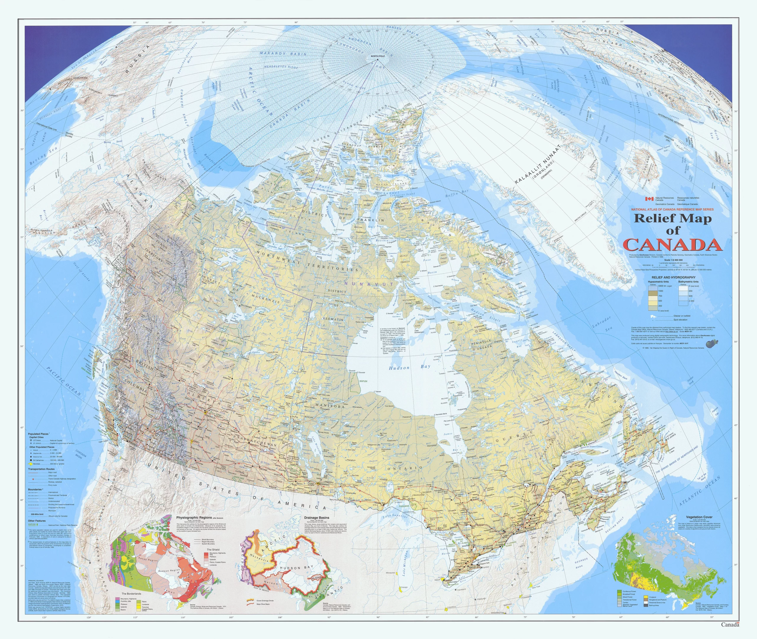
The relief map of Canada, with dimensions of 2560 by 2161 pixels, provides a three-dimensional representation of the country’s physical terrain. It likely showcases the varied topography of Canada, from the towering peaks of the Rocky Mountains to the vast expanses of the Canadian Shield and the rolling plains of the prairies.
Such a map would be particularly useful for educators, students, and anyone interested in the geographical features of Canada. It would allow viewers to visualize the elevation changes across the country and understand how these features influence climate, vegetation, and settlement patterns.
For travelers and outdoor enthusiasts, a relief map is an invaluable tool for planning trips, as it highlights the locations of major mountain ranges, valleys, and plateaus. It can guide those seeking to explore Canada’s natural beauty, whether hiking in the Rockies, fishing in the Great Lakes, or skiing in the Laurentians.
Printable map versions for the Canada Relief Map you may find below.
The Reference Map Series within the Atlas of Canada features a highly detailed digital shaded relief map of Canada. Using bathymetric tints, this map showcases major physical features, including mountain ranges, peaks, spot elevations, and ocean contours. Additionally, all of Canada’s national parks are identified with their extent and name. Populated places are shown in six different population-size classes, while transportation data is limited to two classes.
The map displays all official Canadian, provincial, and surrounding international boundaries, including the proposed boundary for Nunavut, which became a new territory in 1999. It also features the offshore boundary delineating Canada’s exclusive 200-mile fishing and economic zone. Foreign areas have limited data, but shaded relief is still present. The map includes three smaller maps of Canada at a scale 1:35 000 000, which display the major physiographic regions, major drainage basins, and vegetation cover classes.
The data on this map is current to the mid to late 1990s. Overall, this highly detailed map provides a comprehensive and informative view of Canada’s geography and natural features, as well as its official boundaries and national parks.
Printable Maps of the Relief Map of Canada
- Click here to download this map of Canada in a large, printable file in the format JPG.
- Click here to download this map of Canada in a large, printable file in the format PDF.
Did you know about Canadian Geography?
- Canada’s grandeur is not just in its size but also in its natural wonders and the diversity of its landscapes. The country’s vastness means it offers a wide range of climates and ecosystems, from the temperate rainforests of British Columbia to the Arctic tundra of Nunavut.
- The longest Canadian coastline in the world is not just a number; it’s a tapestry of fjords, cliffs, beaches, and bays that host abundant marine life. The coastline is also dotted with vibrant communities, each with a unique maritime culture and history.
- The Canadian Shield is a testament to the Earth’s ancient history, with rocks that tell stories billions of years old. This area is rich in minerals and has been a significant part of Canada’s mining industry. Its vast boreal forests and freshwater lakes make it a hotspot for outdoor activities and a wildlife sanctuary.
- The St. Lawrence River is more than a river; it’s a lifeline for Canada’s economy and environment. It supports a diverse ecosystem and is a crucial habitat for species such as the beluga whale. The river’s basin is also home to a significant portion of Canada’s population, with cities like Montreal and Quebec City offering rich cultural experiences.
- The Northern Lights phenomenon is one of the magical experiences Canada offers, especially in the Yukon, Northwest Territories, and Nunavut. These regions provide some of the best views of the auroras, creating a natural light show that attracts visitors worldwide.
- Canada’s national parks are not just protected wilderness areas but outdoor classrooms and playgrounds. Parks like Banff and Jasper in the Rockies offer breathtaking vistas and are havens for wildlife. They serve as gateways to adventure, whether hiking, mountain biking, or canoeing.
- The Canadian Rockies are not merely a range of mountains but symbols of Canada’s wild heart. Their rugged peaks and serene lakes offer some of the most iconic scenery in the world. The Rockies are also a year-round destination, with world-class skiing in the winter and excellent trails for summer hikes.
- The Prairies are the breadbasket of Canada, with their vast expanses of fields and pastures. This region is integral to the country’s agricultural output, producing a significant portion of the grains and meats consumed in Canada and exported worldwide.
- Canada’s lakes are a defining feature of its geography. Great Bear Lake, the largest entirely within Canada, is just one of the over 2 million lakes that dot the Canadian landscape. These freshwater bodies are crucial for the ecosystem, supporting a wide range of wildlife and providing recreational fishing, boating, and swimming opportunities.
- For visitors, Canada offers an endless array of experiences. Whether exploring the cosmopolitan streets of Toronto, enjoying the gastronomy of Montreal, or seeking solitude in the vastness of the North, Canada’s landscapes are as diverse as the opportunities they present. Each region has its own story, contributing to Canada’s rich tapestry.
Visit this link for other Canada-related reference maps.