CanadaMaps.com presents an extensive and meticulously detailed map of Northern Canada, encompassing the northern expanses of the provinces, the three territories, and the neighboring regions of Russia, Alaska, and Greenland. With a scale of 1:4,000,000, this map is an essential resource for researchers, adventurers, and geography enthusiasts, offering a richly detailed representation of this remote and rugged landscape.
The map’s standout feature is its historical tracking of the Magnetic North Pole’s surveyed locations from 1831 to 2011, providing a crucial navigational aid for compass users in the northern wilderness. Additionally, it includes a special insert of the Labrador coast, illustrating the cultural ties between the Inuit of Nunatsiavut and Nunavut, thereby shedding light on the profound cultural and historical bonds among Indigenous communities in Canada’s north. This map is not just a navigational aid but a window into the diverse cultural fabric of Canada’s expansive northern territories.
Atlas of Northern Canada
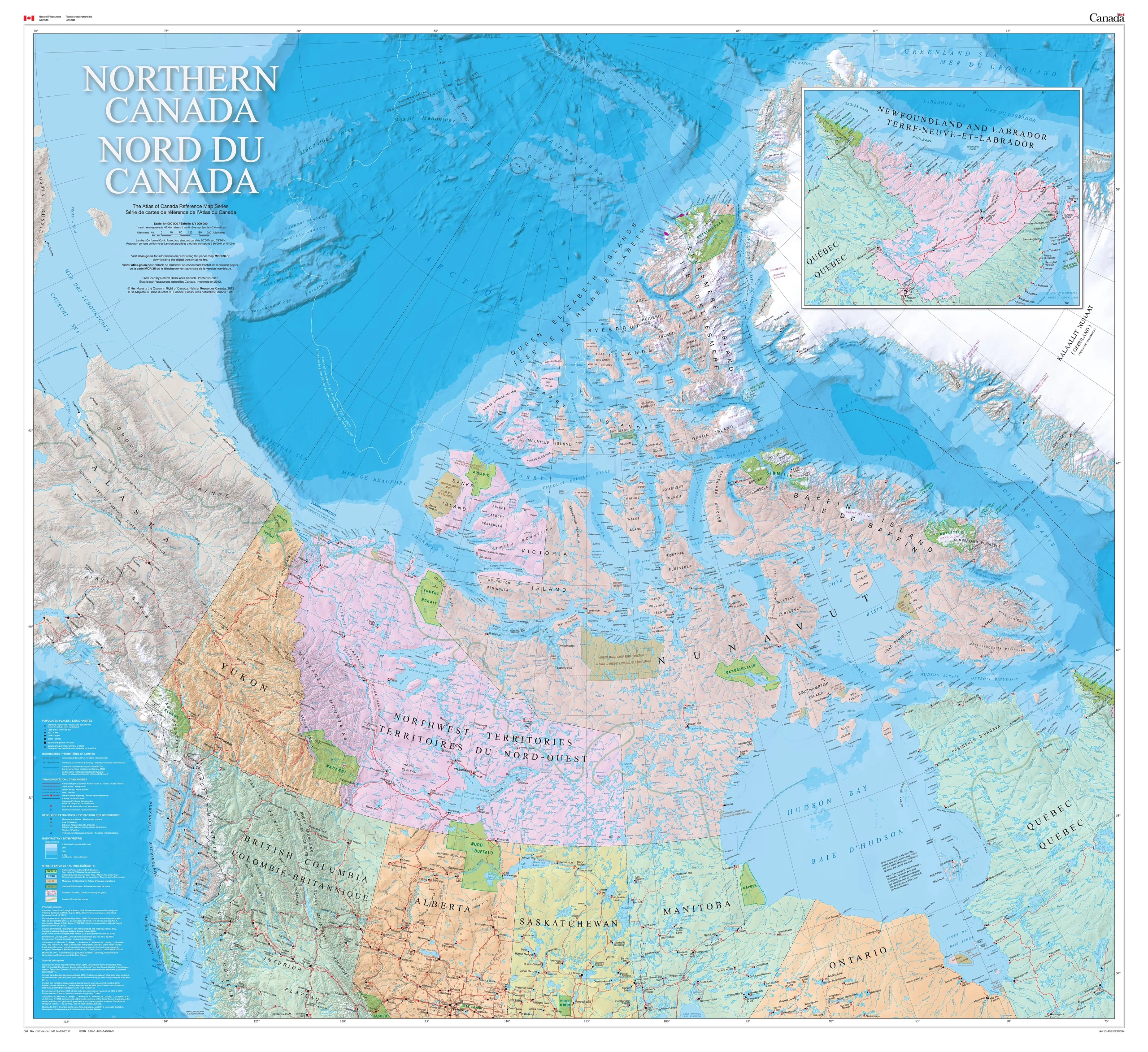
The image from the Atlas of Northern Canada is a detailed reference map that provides a comprehensive overview of the region. The map is scaled at 1:4,000,000, meaning 1 centimeter on the map represents 40 kilometers on the ground. It includes topographical features such as major cities and towns, rivers, lakes, and the Lambert Conformal Conic Projection with standard parallels at 60°00’N and 75°00’N. The map is a product of Natural Resources Canada and was printed in 2012. It is designed to serve as an educational and informational resource for those interested in the geographical layout of Northern Canada.
Downloadable and printable maps are found below.
Downloadable Maps of the Canadian North
The Northern Canada / Nord du Canada map offered by CanadaMaps.com is available to download and print, making it a convenient and accessible resource for anyone interested in exploring the expansive Canadian wilderness situated north of approximately 50° latitude. The map provides a detailed regional base of the north, including the provinces’ three territories and the northern areas. This comprehensive coverage makes it an invaluable tool for researchers, explorers, and anyone interested in geography or Canadian history.
- Click here to download this map of Canada in a large, printable file in the format JPG.
- Click here to download this map of Canada in a large, printable file in the format PDF.
Overall, the Northern Canada / Nord du Canada map, which is available for download and print on CanadaMaps.com, is an essential resource for anyone interested in exploring the rugged and expansive wilderness of Canada’s northern regions. Its comprehensive coverage, accurate depictions of the Magnetic North Pole, and inclusion of cultural and historical information make it an invaluable tool for researchers, travelers, and anyone interested in geography or Canadian history. The map covers all the provinces and territories of Canada, including Yukon, Northwest Territories, Nunavut, British Columbia, Alberta, Saskatchewan, Manitoba, Ontario, Quebec, New Brunswick, Nova Scotia, Prince Edward Island, and Newfoundland and Labrador.
Did you know about Northern Canada?
- Northern Canada is a land of extremes and wonders, boasting the world’s largest expanse of untouched boreal forest, a staggering 1.4 million square kilometers that serve as the lungs of the Earth. The region is also a prime viewing ground for the mesmerizing northern lights, which dance across the sky for more than 200 nights each year, creating a natural light show that is both mystical and awe-inspiring.
- Baffin Island, a giant among the islands of the Canadian Arctic Archipelago, stands larger than several nations, offering a stark and beautiful landscape that is both challenging and inviting to the intrepid explorer. This northern frontier is also a geological treasure trove, with some of the planet’s oldest rocks dating back over 4 billion years, providing a tangible connection to the Earth’s earliest history.
- The region is witness to one of the most impressive wildlife phenomena: the barren-ground caribou’s epic migration, a journey that stretches over 5,000 kilometers annually, a testament to the resilience and adaptability of nature. Beneath the surface, the Northwest Territories cradle the profound depths of Great Slave Lake, North America’s deepest, plunging to 614 meters.
- The opening of the Inuvik-Tuktoyaktuk Highway marked a significant milestone, connecting travelers to the Arctic Ocean and opening up new frontiers for exploration and cultural exchange. Meanwhile, the Canadian Forces Station Alert is a sentinel at the world’s edge, the northernmost permanently inhabited place, where a small, resilient community thrives in isolation.
- Northern Canada is a sanctuary for an array of unique wildlife, from the mighty muskoxen and majestic polar bears to the elusive arctic foxes and the graceful beluga whales, each species an integral part of the delicate Arctic ecosystem. The vast stretches of permafrost underpin this region are not just a feature of the landscape but a critical element in the global climate, storing immense quantities of carbon dioxide. This frozen ground is a silent custodian of our planet’s past and a key to understanding future climate dynamics.
Visit this link for other Canada-related reference maps.