Newfoundland and Labrador

Home » Newfoundland and Labrador » Page 2

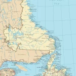
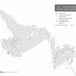
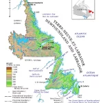
Explore Western Newfoundland with a Detailed Tourist Map

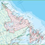
This map shows cities, towns, the Trans-Canada highway, secondary roads, national parks, provincial parks, campgrounds, provincial/national historic sites, airports, local ferries, summer ferries, ski areas, golf courses, and provincial visitor information centers in Western Newfoundland.

Home » Newfoundland and Labrador » Page 2

Discover the Beauty of Newfoundland and Labrador with a Detailed Road Map

This map shows cities, towns, highways, main roads, secondary roads, rivers, lakes, national parks, and provincial parks in Newfoundland and Labrador.

Home » Newfoundland and Labrador » Page 2

Explore the Wonders of Newfoundland and Labrador with a Large Detailed Map

This map shows Newfoundland and Labrador’s cities, towns, rivers, lakes, Trans-Canada highways, major highways, secondary roads, winter roads, railways, and national parks.

Home » Newfoundland and Labrador » Page 2

Explore Eastern Canada’s Natural and Urban Landscapes with Canada Maps

Map of Eastern Canada

This map shows provinces, cities, towns, highways, roads, railways, ferry routes, and national parks in Eastern Canada.

Home » Newfoundland and Labrador » Page 2

Discover Canada’s Cities and Towns with Canada Maps

Map of Canada with cities

This map shows Canada’s provinces, territories, cities, towns, and roads.

Home » Newfoundland and Labrador » Page 2

Discover Canada’s Landscapes and Transportation Networks with Canada Maps

This map shows Canada's provinces, territories, provincial and territorial capitals, cities, towns, highways, roads, trans-Canada highways, railways, and rivers.

This map shows Canada’s provinces, territories, provincial and territorial capitals, cities, towns, highways, roads, trans-Canada highways, railways, and rivers.

Home » Newfoundland and Labrador » Page 2

Discover Canada’s Governmental Boundaries with Canada Maps

This map shows the governmental boundaries of countries, provinces, territories, and provincial and territorial capitals in Canada.

Home » Newfoundland and Labrador » Page 2

Exploring Newfoundland Time Zone (NST) in Canada: A Guide for Travelers and Locals Alike

Newfoundland Time Zone Map

Newfoundland Time Zone (NST) is a fascinating place for travelers and locals. It is the only region in North America that follows the NST. This unique time zone is 30 minutes ahead of Atlantic Standard Time (AST) and 1.5 hours ahead of Eastern Standard Time (EST). Newfoundland and Labrador province is a beautiful and intriguing destination with a rich history and culture. It is also blessed with stunning natural beauty and attractions. Learn more about NST Time Zone here!

Home » Newfoundland and Labrador » Page 2

Newfoundland and Labrador without the names map – Explore Canada with ease using our printable maps!

Newfoundland and Labrador without the names map

The outline map of Newfoundland and Labrador without the names of major political and geographical features is a simplified yet informative representation of the region’s geography. The map highlights Newfoundland and Labrador’s boundary, coastline, and major water systems, including its lakes and rivers. The map can be used for various purposes, including education, research, and recreational activities. It is a valuable tool for exploring, studying, and appreciating the natural beauty of Newfoundland and Labrador’s water resources.

Home » Newfoundland and Labrador » Page 2

Newfoundland and Labrador Relief Map – Explore Canada with ease using our printable maps!

Newfoundland and Labrador Relief Map

The relief map of Newfoundland and Labrador available on our website is an essential resource that provides a wealth of information about the region’s varied and rugged terrain. The hypsometric tints and spot elevations, combined with the legend and detailed data source, make this map an invaluable tool for exploring and understanding the area’s topography.