Newfoundland and Labrador is a breathtakingly beautiful province located in the easternmost region of Canada. The province is renowned for its stunning coastline, rugged landscapes, and unique culture. Whether you are a local or a first-time visitor, this large detailed map of Newfoundland and Labrador will be your ultimate guide to exploring the province’s cities, towns, parks, and much more.
Let’s dive into the features of this map.
Large detailed map of Newfoundland and Labrador with cities and towns
This map shows Newfoundland and Labrador’s cities, towns, rivers, lakes, Trans-Canada highways, major highways, secondary roads, winter roads, railways, and national parks.
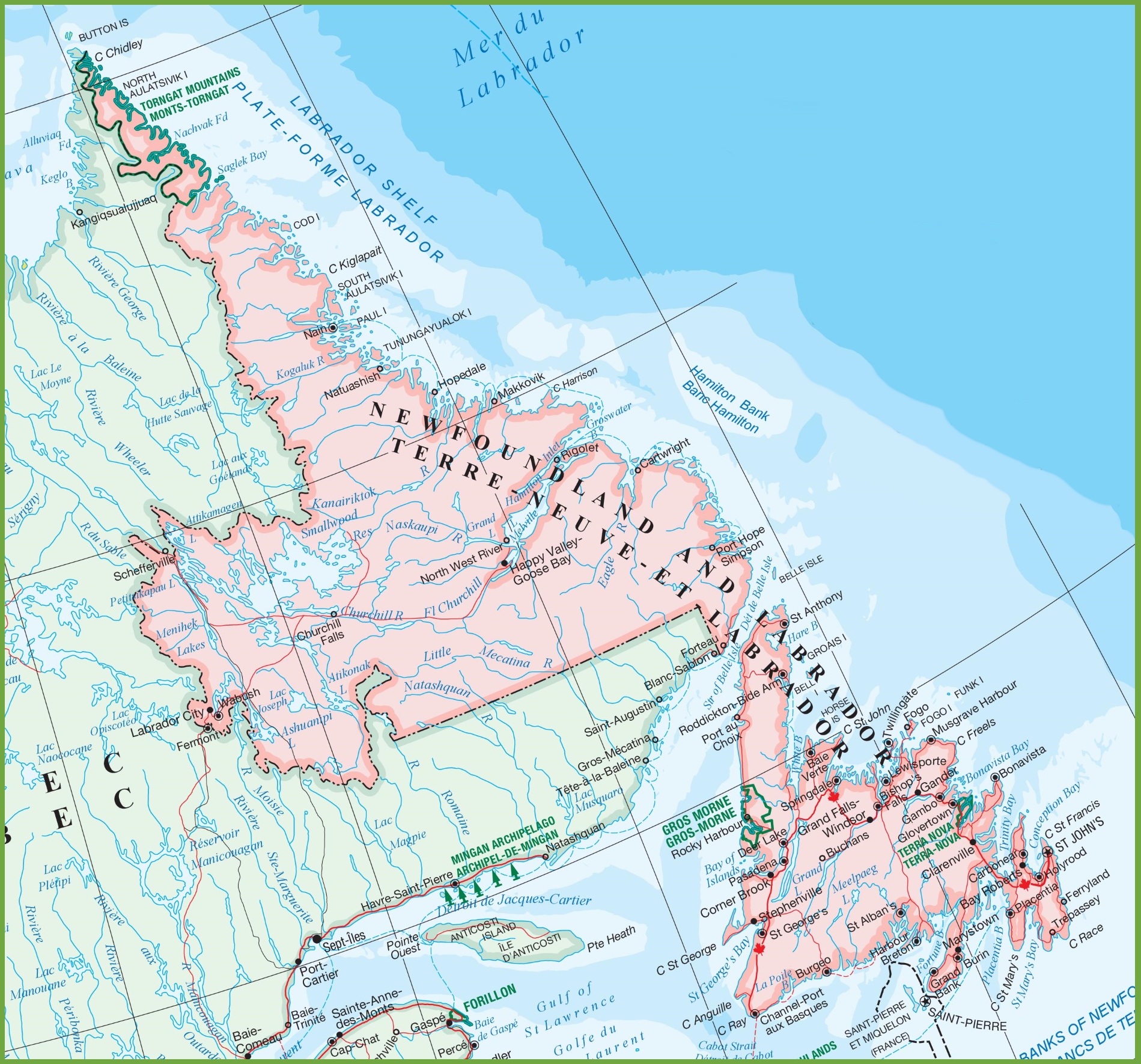
The map of Newfoundland and Labrador with cities and towns is a detailed visual representation, with dimensions of 1899×1770 pixels. It provides a comprehensive view of the province’s urban and rural areas, marking the locations of cities, towns, and the network of roads that connect them. The map also includes significant geographical features such as rivers and coastal lines, and it may also highlight natural attractions and points of interest, making it an invaluable tool for navigation and planning visits to Newfoundland and Labrador’s diverse regions.
Please visit this page for other map resources or Google Maps.
Did you know?
Did you know that Newfoundland and Labrador are home to one of the oldest maps in North America? The Vinland Map, believed to date back to the early 15th century, depicts North America’s northeastern coast, including Newfoundland and Labrador. This map is significant because it is believed to provide evidence of Norse exploration of the region, including the famous Viking explorer Leif Erikson. The map is now housed at Yale University in the United States, but its origins and authenticity are still debated among historians and scholars. Regardless, the Vinland Map is a fascinating piece of history and a testament to the rich cultural heritage of Newfoundland and Labrador.
Cities and Towns
The map highlights all of Newfoundland and Labrador’s major cities and towns, including St. John’s, Gander, Corner Brook, and Labrador City. This feature will help visitors navigate the province and find the nearest urban center for accommodation, dining, and entertainment.
Rivers and Lakes
The map shows Newfoundland and Labrador’s significant rivers and lakes, including the Churchill, Exploits, and Grand Lake. This feature will help visitors plan routes and explore the province’s natural beauty.
Highways and Roads
The map highlights the Trans-Canada highways, major highways, secondary roads, and winter roads in Newfoundland and Labrador. This feature will help visitors plan their routes and navigate the province’s rugged terrain.
Railways
The map shows all of the railways in Newfoundland and Labrador, including the Newfoundland Railway and the Labrador Railway. This feature will help visitors plan transportation and explore the province’s unique history.
National Parks
The map highlights Newfoundland and Labrador’s national parks, including Gros Morne National Park and Terra Nova National Park. This feature will help visitors plan outdoor activities and experience the province’s breathtaking landscapes.
Did you know that Gros Morne National Park, located in western Newfoundland, is a UNESCO World Heritage site? The park is renowned for its stunning landscapes, including the towering fjords, rugged coastline, and Tablelands. This unique geological formation is one of the only places on earth where the earth’s mantle is exposed above the surface. Gros Morne National Park is also home to abundant wildlife, including moose, caribou, and black bears, making it a popular destination for nature enthusiasts. Learn more here about Gros Morne National Park.
Did you know that Terra Nova National Park, located on the east coast of Newfoundland, is one of the few places in the world where you can witness the sunrise first? The park is located in a unique position, allowing visitors to witness the sunrise before anyone else in North America. In addition to its stunning coastal views, Terra Nova National Park is home to an abundance of wildlife, including bald eagles, lynx, and beavers. The park also offers a variety of outdoor activities, including hiking, camping, and fishing, making it a popular destination for outdoor enthusiasts.
Conclusion
Newfoundland and Labrador is a truly unique and stunning province that offers something for everyone. Whether you are interested in exploring the rugged landscapes, learning about the unique culture, or simply relaxing and enjoying the scenery, this large detailed map of Newfoundland and Labrador will be your ultimate guide. So start planning your trip today and discover what this province offers.