Western Newfoundland is a region filled with natural beauty and rich cultural history, and the best way to explore it all is with a detailed tourist map. This map highlights all of the major cities and towns, highways, secondary roads, national and provincial parks, campgrounds, historic sites, airports, ferries, ski areas, golf courses, and visitor information centers in the region, making it the perfect tool for planning your next adventure.
Let’s dive into the features of this map.
Western Newfoundland Tourist Map
This map shows cities, towns, the Trans-Canada highway, secondary roads, national parks, provincial parks, campgrounds, provincial/national historic sites, airports, local ferries, summer ferries, ski areas, golf courses, and provincial visitor information centers in Western Newfoundland.
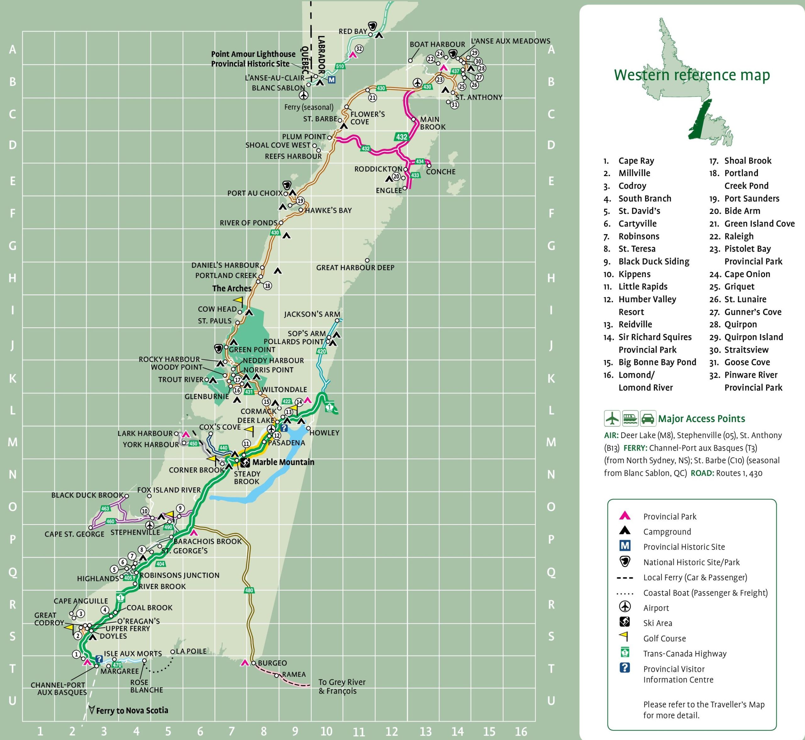
The Western Newfoundland tourist map is a detailed visual guide with a resolution of 2560×2353 pixels. It highlights the region’s attractions, including the Gros Morne National Park, a UNESCO World Heritage Site known for its stunning landscapes and geological formations. The map also features the Viking Trail leading to the L’Anse aux Meadows National Historic Site, where visitors can explore the only known Norse settlement in North America. Other points of interest marked on the map include the scenic Humber Valley, the historic fishing community of Trout River, and the Marble Mountain Resort, known for its skiing and snowboarding. This map is an essential companion for tourists seeking to discover the rich natural and cultural heritage of Western Newfoundland.
Please visit this page for other map resources or Google Maps.
What is on the tourist map of Western Newfoundland Tourist Map above?
The Western Newfoundland tourist map is excellent for exploring some of the region’s most beautiful destinations. From the picturesque town of Cape Ray, located at the southwestern tip of Newfoundland, to the serene Pinware River Provincial Park in the north, there are many highlights to discover. Millville and Codroy offer tranquil settings for enjoying the region’s natural beauty, while South Branch and St. David’s provide access to hiking trails and outdoor adventure. Cartyville, Robinsons, St. Teresa, Black Duck Siding, and Kippens are all charming small towns with friendly locals.
At the same time, Little Rapids and Humber Valley Resort are perfect for outdoor enthusiasts, with opportunities for skiing and golfing. Sir Richard Squires Provincial Park and Pistolet Bay Provincial Park offer visitors a chance to camp and explore the area’s natural wonders. Big Bonne Bay Pond, Lomond/Lomond River, Shoal Brook, Portland Creek Pond, Port Saunders, Bide Arm, Green Island Cove, Raleigh, Griquet, St. Lunaire, Gunner’s Cove, Ouirpon, and Ouirpon Island are all beautiful locations for enjoying the great outdoors.
Whether you are looking to hike, camp, ski, or take in stunning scenery, the Western Newfoundland tourist map has everything you need to plan an unforgettable adventure.
Cities and Towns: The map highlights all of the major cities and towns in Western Newfoundland, including Corner Brook, Stephenville, and Port aux Basques. This feature will help visitors navigate the region and find the nearest urban center for accommodation, dining, and entertainment.
Highways and Roads: The map shows all major highways and secondary roads in Western Newfoundland, including the Trans-Canada Highway, the Viking Trail, and the Humber Valley Parkway. This feature will help visitors plan their routes and navigate the region’s rugged terrain.
National and Provincial Parks: The map shows all of the national and provincial parks in Western Newfoundland, including Gros Morne National Park, a UNESCO World Heritage Site, and Terra Nova National Park. This feature will help visitors plan outdoor activities and experience the region’s breathtaking landscapes.
Campgrounds and Historic Sites: The map highlights the campgrounds and provincial/national historic sites in Western Newfoundland, including the L’Anse aux Meadows National Historic Site, the only authenticated Viking settlement in North America. This feature will help visitors plan activities and learn about the region’s rich cultural history.
Airports and Ferries: The map shows all the airports and local/summer ferries in Western Newfoundland, including the Port aux Basques to North Sydney ferry and St. Barbe to Blanc Sablon ferry. This feature will help visitors plan their travel and transportation options in the region.
Ski Areas and Golf Courses: The map highlights all of the ski areas and golf courses in Western Newfoundland, including the Marble Mountain Ski Resort and the Humber Valley Resort. This feature will help visitors plan their winter and summer activities in the region.
Visitor Information Centers: The map shows all of the provincial visitor information centers in Western Newfoundland, including the Gros Morne National Park Visitor Center and the Corner Brook Visitor Information Center. This feature will help visitors plan their trips and maximize their time in the region.
Conclusion
Western Newfoundland is a region filled with natural beauty and rich cultural history, and there’s no better way to explore it than with a detailed tourist map. This map will help visitors navigate the region’s rugged terrain, plan their routes, and experience all of the great outdoor activities and breathtaking landscapes that Western Newfoundland offers.