map

Home » map » Page 6

Discover the Best of Southern Ontario: A Map of Cities, Rivers, and Highways

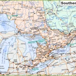
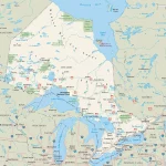
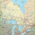
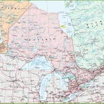
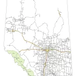
This map shows cities, towns, rivers, lakes, major roads, minor roads, railways, and Trans-Canada highways in Southern Ontario.

Home » map » Page 6

Navigate Ontario with Ease: A Map of Highways, Cities, and Points of Interest

This map shows highways in Ontario. Cities, towns, counties, interprovince highways, Canada highways, province highways, main roads, secondary roads, rivers, lakes, airports, national parks, rest areas, welcome centers, Indian reservations, scenic byways, and points of interest in Ontario. Hotels, resorts, beaches, national parks, rest areas, welcome centers, Indian reservations, scenic byways, points of interest, tourist attractions, and sightseeing in Ontario.

Home » map » Page 6

Discover Alberta: A Tourist Map Featuring Cities, Towns, and UNESCO World Heritage Sites

This map shows cities, towns, regions, visitor information centers, UNESCO world heritage sites, airports, primary highways, Trans-Canada, Crowsnest, and U.S. ports of entry.

Home » map » Page 6

Explore the Natural Wonders of Alberta: A Comprehensive Map of Cities, Highways, Parks, and More

This map shows Alberta’s cities, towns, highways, main roads, secondary roads, rivers, lakes, national parks, and provincial parks.

Home » map » Page 6

Nova Scotia without names map – Explore Canada with ease using our printable maps!

Nova Scotia without names map

The outline map of Ontario depicts the province’s boundary, coastline, and major water systems, offering a simplified and clear view of the region’s significant features. By excluding the names of major political and geographical features, the map emphasizes the importance of Ontario’s essential water bodies, which have played a crucial role in the province’s history and development. The map can be helpful for various purposes, including educational, environmental, and recreational pursuits.