Eastern Newfoundland is a stunning region with a rich history, breathtaking landscapes, and vibrant communities. Whether you’re a first-time visitor or a local looking to explore more of the area, a tourist map is an essential tool to help you plan your journey and discover the hidden gems that make Eastern Newfoundland unique. This map highlights cities, towns, the Trans-Canada highway, secondary roads, national parks, provincial parks, campgrounds, provincial/national historic sites, airports, local ferries, summer ferries, ski areas, golf courses, and provincial visitor information centers in Eastern Newfoundland, making it the perfect resource for anyone looking to explore the region.
Eastern Newfoundland Tourist Map
This map shows cities, towns, the Trans-Canada highway, secondary roads, national parks, provincial parks, campgrounds, provincial/national historic sites, airports, local ferries, summer ferries, ski areas, golf courses, and provincial visitor information centers in Eastern Newfoundland.
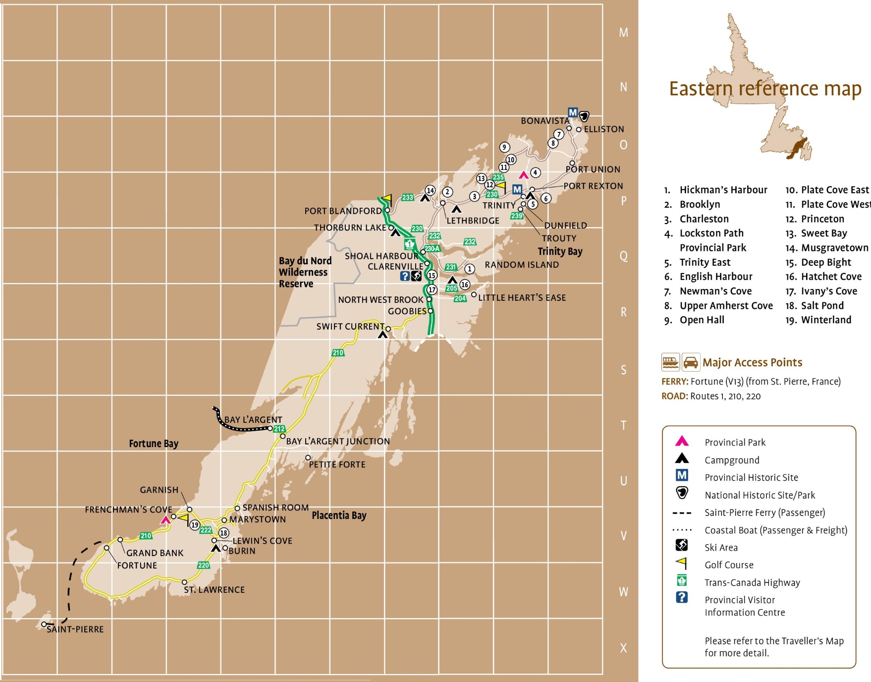
The Eastern Newfoundland tourist map, with dimensions of 1758×1376 pixels, showcases the region’s key attractions and points of interest. It includes major access points like the ferry from St. Pierre, France, to Fortune, and highlights various routes such as Routes 1, 210, and 220. The map points out provincial parks, campgrounds, historic sites, and other tourist destinations such as ski areas and golf courses. It’s a valuable guide for visitors looking to explore Eastern Newfoundland’s rich cultural heritage and natural beauty.
Please visit this page for other map resources or Google Maps.
What is a Tourist Map Used for?
A tourist map is an excellent tool for travelers exploring an area in-depth. Whether local or a visitor, a map can help you navigate the region’s roads and discover hidden gems. Eastern Newfoundland tourist map highlights cities, towns, Trans-Canada Highway, secondary roads, national parks, provincial parks, campgrounds, provincial/national historic sites, airports, local ferries, summer ferries, ski areas, golf courses, and provincial visitor information centers in the region. The map also includes distances between towns and cities to plan your journey accordingly.
What’s on this Eastern Newfoundland Tourist Map?
Eastern Newfoundland has many charming towns and villages, each with a unique character and history. Hickman’s Harbour, Brooklyn, and Charleston are three towns worth exploring. These towns offer a glimpse into life in Eastern Newfoundland and are excellent places to stop and stretch your legs during a road trip.
Lockston Path Provincial Park is another highlight of the region. This beautiful park offers hiking trails through dense forests and past sparkling lakes. It’s an excellent spot for a picnic or a swim, and the peaceful setting makes it a perfect escape from the hustle and bustle of daily life.
Trinity East, English Harbour, Newman’s Cove, Upper Amherst Cove, Open Hall, Plate Cove East, Plate Cove West, Princeton, Sweet Bay, Musgravetown, Deep Bight, Hatchet Cove, Ivany’s Cove, Salt Pond, and Winterland are other towns and villages in Eastern Newfoundland that offer plenty to see and do. These communities have a rich history; exploring them is an excellent way to gain insight into the region’s culture and way of life. You may find on the tourist map above:
- Hickman’s Harbour
- Brooklyn
- Charleston
- Lockston Path Provincial Park
- Trinity East
- English Harbour
- Newman’s Cove
- Upper Amherst Cove
- Open Hall
- Plate Cove East
- Plate Cove West
- Princeton
- Sweet Bay
- Musgravetown
- Deep Bight
- Hatchet Cove
- Ivany’sCove
- Salt Pond
- Winterland
With so many towns to discover, a tourist map is essential to help you plan your journey and ensure you don’t miss any of Eastern Newfoundland’s hidden gems.
Did you Know about Eastern Newfoundland?
Eastern Newfoundland is home to some of Canada’s most unique and captivating attractions. The region is home to Terra Nova National Park, a beautiful wilderness area that offers hiking, camping, and wildlife viewing opportunities. History buffs will love exploring the Cape Spear Lighthouse National Historic Site, the oldest surviving lighthouse in Newfoundland and Labrador. Other notable attractions in Eastern Newfoundland include the Signal Hill National Historic Site, a military fortification that played a crucial role in defense of the region, and the stunning beaches of Bonavista.
Exploring Eastern Newfoundland with a Tourist Map
With so much to see and do in Eastern Newfoundland, it can be challenging to know where to start. That’s where a tourist map comes in handy. The map lets you plan your journey, take detours to explore smaller towns and attractions, and experience the region’s natural beauty at your own pace. Some of the best driving routes in Eastern Newfoundland include the Bonavista Peninsula, which offers stunning coastline views and the chance to spot whales and seabirds, and the Irish Loop, which takes you through charming villages past historic sites.
Conclusion
If you’re planning a trip to Eastern Newfoundland, a tourist map is essential to help you navigate the region and discover its hidden gems. With so much to see and do, planning your journey and exploring at your own pace will ensure you make the most of your time in this stunning part of Canada.