Are you looking for an exciting adventure that takes you through some of the most breathtaking landscapes in Canada? Look no further than Western Newfoundland, a region with a stunning mix of rugged coastlines, towering mountains, and tranquil lakes. With a scenic driving routes map, you can explore this region at your own pace and explore the natural wonders that make Western Newfoundland unique.
Western Newfoundland Scenic Driving Routes Map
This map shows cities, towns, trails, Trans-Canada highways, secondary roads, national parks, provincial parks, provincial visitor information centers, provincial/national historic sites, ferries, airports, and natural scenic attractions in Western Newfoundland.
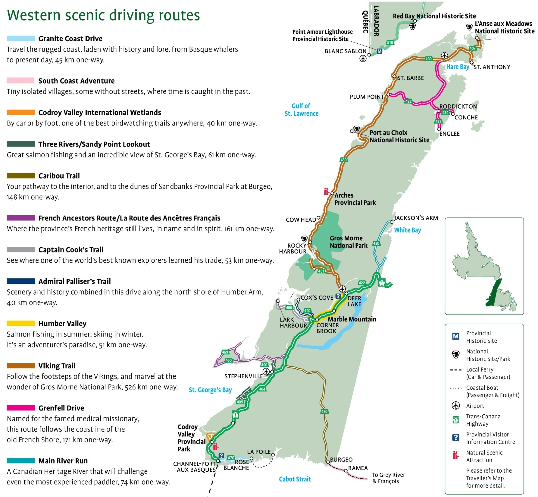
The Western Newfoundland Scenic Driving Routes map is a detailed guide for travelers seeking to explore the region’s picturesque landscapes and historical sites. The map, with dimensions of 1786×1648 pixels, outlines several themed routes, such as:
- Granite Coast Drive: A 45 km journey along a rugged coast rich in history, from the era of Basque whalers to the present.
- South Coast Adventure: A route through tiny, timeless villages, some without streets, offering a glimpse into the past.
- Codroy Valley International Wetlands: A 40 km path ideal for birdwatching, accessible by car or on foot.
- Three Rivers/Sandy Point Lookout: A 61 km route known for excellent salmon fishing and stunning views of St. George’s Bay.
- Caribou Trail: A 148 km drive to the interior leading to Sandbanks Provincial Park’s dunes at Burgeo.
- French Ancestors Route: A 161 km drive celebrating the province’s French heritage.
- Captain Cook’s Trail: A 53 km route where the famous explorer honed his skills.
- Admiral Palliser’s Trail: Combines scenery and history along the north shore of Humber Arm, spanning 40 km.
- Humber Valley: Offers salmon fishing in summer and skiing in winter over a 51 km stretch.
- Viking Trail: A 526 km journey following the Vikings’ footsteps, with the Gros Morne National Park as a highlight.
- Grenfell Drive: A 171 km coastal drive named after the renowned medical missionary tracing the old French Shore.
- Main River Run: A 74 km Canadian Heritage River challenge for experienced paddlers.
The map also includes symbols for provincial parks, historic sites, ecological reserves, airports, ferry routes, and visitor information centers, making it an essential tool for anyone driving through Western Newfoundland.
Please visit this page for other map resources or Google Maps.
What are Scenic Driving Routes Maps Used for?
The Western Newfoundland scenic driving routes map is an excellent resource for exploring the region’s most beautiful natural landscapes. The map highlights some of the area’s best scenic routes and natural attractions, including national and provincial parks, historic sites, and trails. The Trans-Canada Highway and secondary roads offer stunning views of the coastline and the majestic mountains of Western Newfoundland. The map also includes information on provincial visitor information centers, airports, and ferries, making it easy to plan your itinerary. You can explore the stunning scenery of Gros Morne National Park, the Bay of Islands’ rugged coastline, or the Northern Peninsula’s stunning fjords. The scenic driving routes map also highlights several natural scenic attractions, such as the breathtaking Western Brook Pond, the magnificent Tablelands, and the stunning Blow Me Down Mountains. From the charming coastal towns of Rocky Harbour, Woody Point, and Trout River to the stunning natural scenery of the region, the Western Newfoundland scenic driving routes map has everything you need to plan an unforgettable road trip. Whether you are looking for adventure or relaxation, this map is the perfect guide to exploring the beauty of Western Newfoundland.
Did you Know about Western Newfoundland?
Western Newfoundland is home to Gros Morne National Park, a UNESCO World Heritage site that boasts some of Canada’s most striking natural landscapes. The park features the Tablelands, a section of the earth’s mantle pushed to the surface, creating a unique geological phenomenon. Gros Morne is also home to the Long Range Mountains, a range that runs through the park and offers some of the most stunning hiking trails in the region. Other notable attractions in Western Newfoundland include the L’Anse aux Meadows National Historic Site, a Viking settlement dating back to 1000 AD, and the Blow Me Down Provincial Park, which offers excellent opportunities for hiking, kayaking, and fishing.
Exploring Western Newfoundland with a Scenic Driving Routes Map With so much to see and do in Western Newfoundland, it can be challenging to know where to start. That’s where a scenic driving routes map comes in handy. The map lets you plan your journey, take detours to explore smaller towns and attractions and experience the region’s natural beauty at your own pace. Some of the best driving routes in Western Newfoundland include the Viking Trail, which takes you through Gros Morne National Park along the rugged coastline, and the Humber Valley, which offers stunning views of the Long Range Mountains and the Humber River.
Conclusion
If you’re planning a trip to Western Newfoundland, a scenic driving routes map is essential to help you navigate the region and discover its hidden gems. With so much to see and do, planning your journey and exploring at your own pace will ensure you make the most of your time in this stunning part of Canada.