Eastern Newfoundland is a region of Canada that boasts stunning natural beauty, from rugged coastlines to lush forests and rolling hills. With a scenic driving route map, you can explore the region’s natural wonders and discover its hidden gems. The map highlights cities, towns, trails, the Trans-Canada highway, secondary roads, national parks, provincial parks, provincial visitor information centers, provincial/national historic sites, ferries, airports, and natural scenic attractions in Eastern Newfoundland.
Eastern Newfoundland Scenic Driving Routes Map
This map shows cities, towns, trails, Trans-Canada highways, secondary roads, national parks, provincial parks, provincial visitor information centers, provincial/national historic sites, ferries, airports, and natural scenic attractions in Eastern Newfoundland.
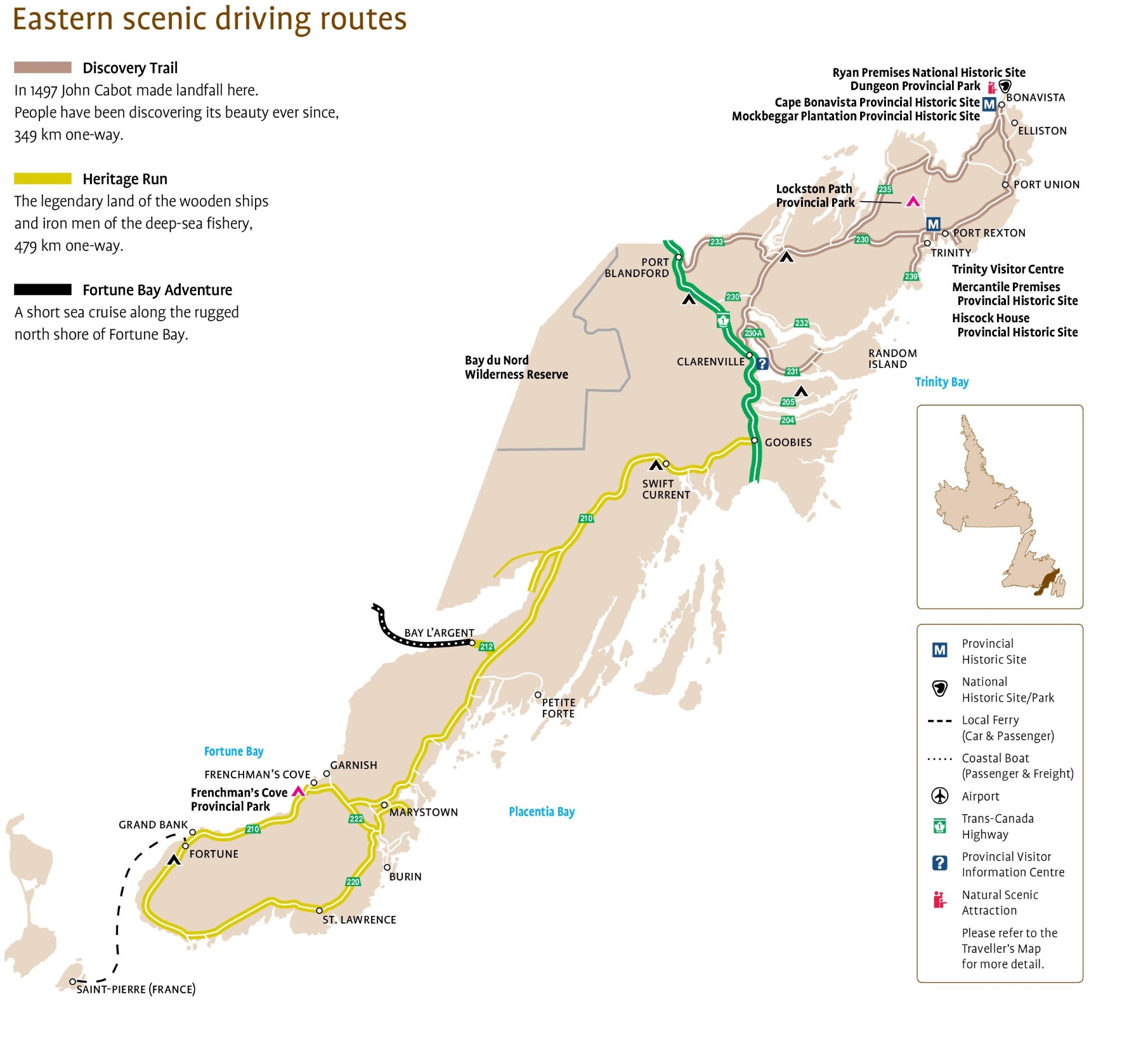
The Eastern Newfoundland Scenic Driving Routes map, with dimensions of 1810×1649 pixels, provides a guide to some of the most picturesque drives in the region. It includes:
- Discovery Trail: A 349 km route where John Cabot made landfall in 1497, offering a journey through the area’s natural beauty.
- Heritage Run: A 479 km drive through the land of historic deep-sea fisheries.
- Fortune Bay Adventure: A coastal route along Fortune Bay’s rugged north shore.
The map also marks significant historical and natural sites, such as the Mockbeggar Plantation, Ryan Premises, and Cape Bonavista, along with provincial parks and visitor centers. Symbols indicate various points of interest, including provincial historic sites, national historic sites/parks, ferry routes, airports, and the Trans-Canada Highway. This map is a valuable resource for anyone looking to explore Eastern Newfoundland’s rich history and stunning landscapes.
Please visit this page for other map resources or Google Maps.
Scenic Driving Routes in Eastern Newfoundland
Driving routes are an excellent way to explore Eastern Newfoundland and its natural beauty. The region’s rugged coastline, rolling hills, and lush forests offer stunning views that are best experienced by car. The scenic driving routes on this map will take you through charming towns and villages, past historical sites and natural attractions, and along breathtaking coastlines. Some of the most popular driving routes in Eastern Newfoundland include the Irish Loop, which takes you past historic sites and charming villages, and the Baccalieu Trail, which offers stunning coastline views and opportunities to spot whales and seabirds.
What are the Scenic Driving Routes?
Discovery Trail: In 1497, John Cabot made landfall here. People have been discovering its beauty ever since. 349 km one-way.
The Discovery Trail is a 349-kilometer scenic driving route that takes visitors along the eastern coast of Newfoundland. The trail follows the path of John Cabot, who made landfall in Newfoundland in 1497. Along the way, visitors can discover the region’s natural beauty, including rugged coastlines, sandy beaches, and quaint fishing villages. The trail also passes through several provincial parks, including Terra Nova National Park and Cape Bonavista Lighthouse Provincial Park, where visitors can hike, camp, and explore historical sites.
Heritage Run: The legendary land of the deep-sea fishery’s wooden ships and iron men, 479 km one-way.
The Heritage Run is a 479-kilometer scenic driving route that takes visitors through the heart of Newfoundland’s fishing history. The route passes through charming fishing villages and towns, including Bonavista, Trinity, and Twillingate, where visitors can learn about the region’s rich fishing heritage. The Heritage Run also passes through several provincial parks, including Terra Nova National Park and Dildo Run Provincial Park, where visitors can hike, camp, and explore the region’s natural beauty.
Fortune Bay Adventure: A short sea cruise along the rugged north shore of Fortune Bay.
The Fortune Bay Adventure is a short sea cruise along the rugged north shore of Fortune Bay. Visitors can take in the stunning views of the coastline and spot wildlife, including whales and seabirds. The cruise also stops at several historic sites, including the fishing village of Rencontre East, where visitors can learn about the region’s fishing history and culture.
Exploring Eastern Newfoundland’s Scenic Driving Routes: Eastern Newfoundland’s scenic driving routes offer visitors a unique way to explore the region’s natural beauty and rich history. From the rugged coastlines and sandy beaches of the Discovery Trail to the charming fishing villages and historical sites along the Heritage Run, there is something for everyone to discover in this part of Canada. The Fortune Bay Adventure provides a unique perspective of the region’s coastline and wildlife, making it a must-do experience for any visitor.
Did you Know about Eastern Newfoundland’s Natural Attractions?
Eastern Newfoundland is home to many natural attractions that are worth exploring. Terra Nova National Park is a beautiful wilderness area that offers hiking, camping, and wildlife viewing opportunities. The park’s rugged coastline has secluded coves and sandy beaches, making it a perfect spot for a picnic or a swim. The Cape St. Mary’s Ecological Reserve is another natural wonder in Eastern Newfoundland. This reserve is home to a breeding colony of northern gannets, which are large, beautiful seabirds. Visitors can watch these birds soar above the cliffs and dive into the ocean to catch fish.
Exploring Eastern Newfoundland with a Scenic Driving Route Map
With many natural attractions in Eastern Newfoundland, a scenic driving route map is essential for any traveler. The map allows you to plan your journey and take detours to explore smaller towns and natural attractions. Whether you’re interested in hiking, wildlife viewing, or simply taking in stunning views, there is something for everyone to discover in this part of Canada.
Conclusion
Eastern Newfoundland is a region of Canada rich in natural beauty and history. With a scenic driving route map, you can explore the region’s hidden gems and take in its breathtaking landscapes at your own pace. From charming towns and villages to rugged coastlines and lush forests, there is something for everyone to discover in this part of Canada.