Welcome to CanadaMaps.com! If you’re planning a road trip to Avalon, Newfoundland, you’ll want to get your hands on our latest map of the region. Our Avalon scenic driving routes map is the ultimate resource for anyone who wants to explore the area’s stunning natural beauty, charming towns, and rich history. This blog post will give you a quick overview of what the map includes and how it can enhance your road trip experience.
Avalon Scenic Driving Routes Map
This map shows cities, towns, trails, Trans-Canada highways, secondary roads, national parks, provincial parks, provincial visitor information centers, provincial/national historic sites, ferries, airports, and natural scenic attractions in Avalon.
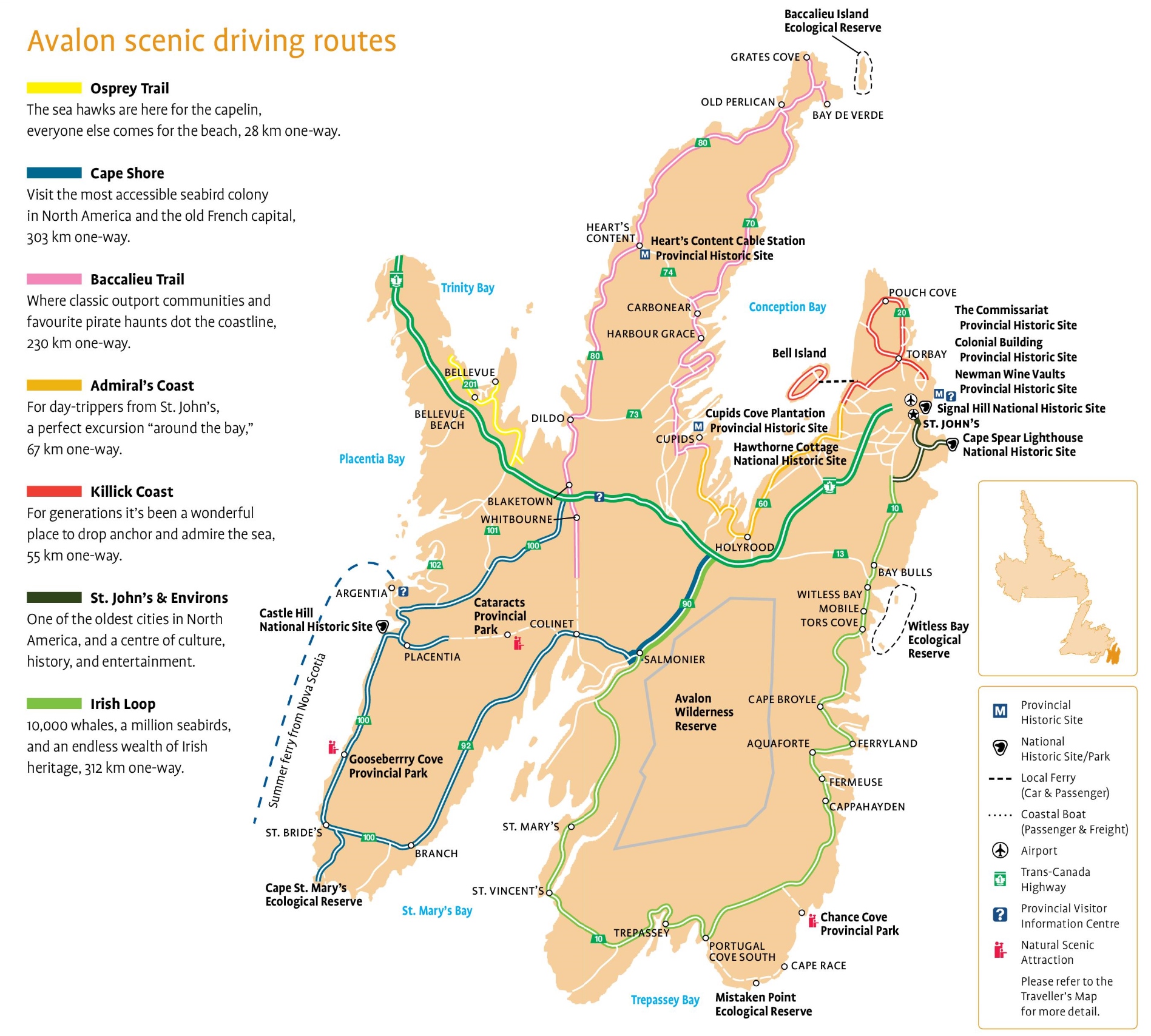
The Avalon Scenic Driving Routes map, with dimensions of 1897×1708 pixels, showcases a collection of picturesque drives across the Avalon Peninsula.
Please visit this page for other map resources or Google Maps.
Did You Know About Canada’s Avalon Region?
The Avalon region in Newfoundland is home to some of Canada’s most breathtaking natural scenery. Our scenic driving routes map highlights the region’s most popular attractions, including the Osprey Trail, Cape Shore, Baccalieu Trail, Admiral’s Coast, Killick Coast, St. John’s & Environs, and the Irish Loop.
Osprey Trail: The Osprey Trail is a must-see for bird lovers, as it is home to a large population of ospreys who come to the area for the capelin. However, even if you’re not a bird enthusiast, the trail’s beautiful beaches are worth the 28 km one-way trip.
Cape Shore: Cape Shore is another highlight of the Avalon region, offering visitors the chance to visit the most accessible seabird colony in North America and explore the old French capital. With a one-way distance of 303 km, this route is perfect for a day trip or a more extended adventure.
Baccalieu Trail: The Baccalieu Trail is an excellent choice for those who want to experience classic outport communities and pirate haunts along the coastline. With a distance of 230 km one-way, this route will take you on a journey through Newfoundland’s rich history and culture.
Admiral’s Coast: The Admiral’s Coast is a perfect excursion “around the bay” for day-trippers from St. John’s. With a one-way distance of 67 km, this route offers stunning coastline views and the opportunity to explore charming communities.
Killick Coast: The Killick Coast has been a favorite spot for generations to drop anchor and admire the sea. With a distance of 55 km one-way, this route offers a tranquil escape from the hustle and bustle of city life.
St. John’s & Environs: Speaking of cities, St. John’s & Environs is one of the oldest cities in North America and a center of culture, history, and entertainment. With our scenic driving routes map, you can easily explore the city’s top attractions and nearby areas, including Signal Hill, Cape Spear, and Quidi Vidi Village.
Irish Loop: Finally, the Irish Loop offers a unique blend of natural beauty and cultural heritage, with 10,000 whales, a million seabirds, and an endless wealth of Irish history to discover along the 312 km one-way route.
In conclusion, our Avalon scenic driving routes map offers a comprehensive guide to some of Newfoundland’s most beautiful and fascinating areas. Whether you’re a nature lover, a history buff, or just looking for a scenic road trip, our map has something for everyone. So what are you waiting for? Start planning your journey today and discover all that the Avalon region has to offer.
Map features of Avalon Scenic Driving Routes
Our Avalon scenic driving routes map is packed with features that will help you plan your trip and navigate your way through the region. Here are some of the highlights:
- Cities and towns: The map includes all the major cities and towns in Avalon and smaller communities worth visiting.
- Trails: You’ll love our map’s detailed trail information if you’re an avid hiker. We highlight some of the best hiking trails in the region, including the East Coast Trail and the Cape Chapeau Rouge Trail.
- Highways and secondary roads: The map shows the region’s major highways and secondary roads, making it easy to plan your route and stay on track.
- National and provincial parks: Avalon is home to some of the most stunning parks in Canada, and our map includes information about all of them. From the rugged beauty of Cape St. Mary’s Ecological Reserve to the picturesque scenery of Butter Pot Provincial Park, you won’t want to miss any of these natural wonders.
- Visitor information centers: Our map includes the locations of all the provincial visitor information centers in Avalon. These centers are excellent travel resources, offering helpful advice, brochures, and maps.
- Historic sites: As we mentioned earlier, our map highlights many of the historic sites in Avalon. These include national and provincial historical sites and important landmarks like the Cape Spear Lighthouse and Signal Hill National Historic Site.
- Ferries and airports: If you’re arriving in Avalon by ferry or plane, our map includes information about the region’s airports and ferry terminals.
- Natural scenic attractions: From rugged coastlines to pristine lakes, Avalon is home to some of Canada’s most breathtaking natural scenery. Our map includes information about the region’s top natural attractions, including the iconic Signal Hill and the stunning Witless Bay Ecological Reserve.
What are such maps used for?
Scenic driving route maps are a must-have for anyone who loves to explore new places by car. These maps highlight the best routes to experience the most breathtaking scenery, exciting attractions, and hidden gems a region offers. Our Avalon scenic driving routes map is no exception. Whether you’re a seasoned road-tripper or a first-time visitor to Newfoundland, this map will help you plan an unforgettable journey.
Did you know about Canada?
Did you know that Newfoundland is the easternmost province in Canada? It’s located in the Atlantic Time Zone, half an hour ahead of Eastern Standard Time. Newfoundland is also home to some of the oldest settlements in North America, with a rich history that spans centuries. Our Avalon scenic driving routes map highlights many of the province’s historic sites, including national historic sites like Castle Hill and the Ryan Premises and local historic sites like the Cape Spear Lighthouse and the Heart’s Content Cable Station. By following the routes on our map, you’ll have the opportunity to learn about the fascinating history of this unique region.
Conclusion
Whether planning a leisurely road trip or an action-packed adventure, our map will help you make the most of your time in Avalon. With detailed information about all of the region’s top attractions, as well as insider tips and recommendations, our map is your key to an unforgettable journey. So what are you waiting for? Start planning your Avalon road trip today, and don’t forget to grab a copy of our scenic driving routes map to guide you along the way. Happy travels!