Central Newfoundland is a region of natural beauty, history, and culture waiting to be explored. From quaint fishing villages to sprawling national parks, the region offers an array of attractions for visitors of all ages. One of the best ways to experience the region’s beauty is through scenic driving routes. With our Central Newfoundland scenic driving routes map, you can easily plan your trip and discover the region’s hidden gems.
Central Newfoundland Scenic Driving Routes Map
This map shows cities, towns, trails, Trans-Canada highways, secondary roads, national parks, provincial parks, provincial visitor information centers, provincial/national historic sites, ferries, airports, and natural scenic attractions in Central Newfoundland.
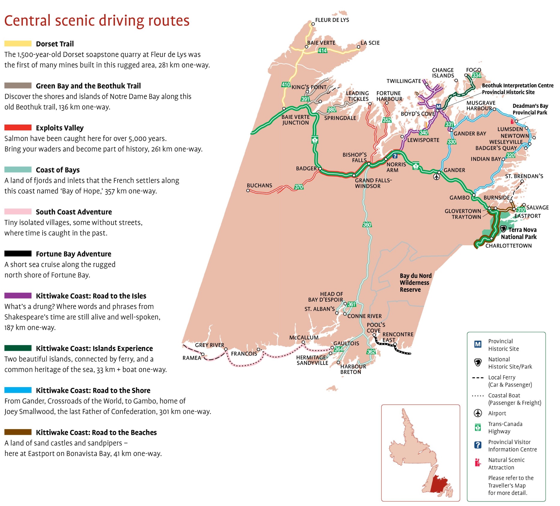
The Central Newfoundland Scenic Driving Routes map, with dimensions of 1866×1686 pixels, outlines various thematic routes for travelers to explore the heart of Newfoundland (see below).
Please visit this page for other map resources or Google Maps.
What’s included on the scenic route map above?
Central Newfoundland scenic driving routes map features various scenic driving routes, and each route offers something unique and exciting to explore.
Let’s take a closer look at some of the routes included in the map:
- Dorset Trail: The Dorset Trail is a 281 km one-way scenic driving route that takes visitors through the rugged terrain of Central Newfoundland. This route leads to the 1,500-year-old Dorset soapstone quarry at Fleur de Lys, the first of many mines built in this area. Visitors can explore the ancient quarry and learn about the Dorset people’s history.
- Green Bay and the Beothuk Trail: The Green Bay and the Beothuk Trail is a 136 km one-way scenic driving route that takes visitors through the shores and islands of Notre Dame Bay. This route follows an old Beothuk trail, and visitors can discover the cultural heritage of the Beothuk people who have lived there for thousands of years.
- Exploits Valley: The Exploits Valley is a 261 km one-way scenic driving route that takes visitors through the beautiful valley of the Exploits River. This area is known for its salmon fishing, a tradition for over 5,000 years. Visitors can bring their waders and become part of history by trying their luck at salmon fishing in the river.
- Coast of Bays: The Coast of Bays is a 357 km one-way scenic driving route that takes visitors through a land of fjords and inlets. This area was named the “Bay of Hope” by French settlers who first arrived here. Visitors can explore the stunning natural beauty of this area and learn about its history.
- South Coast Adventure: The South Coast Adventure is a scenic driving route that takes visitors through tiny isolated villages that seem stuck in time. Some of these villages do not even have streets, and visitors can experience the simple way of life of those who live here.
- Fortune Bay Adventure: The Fortune Bay Adventure is a short sea cruise along the rugged north shore of Fortune Bay. Visitors can explore the stunning coastline and learn about the history of this area.
- Kittiwake Coast: Road to the Isles: The Kittiwake Coast: Road to the Isles is a 187 km one-way scenic driving route that takes visitors through an area where words and phrases from Shakespeare’s time are still alive and well-spoken. Visitors can explore the unique cultural heritage of this area and learn about its history.
- Kittiwake Coast: Islands Experience: The Kittiwake Coast: Islands Experience is a scenic driving route that takes visitors to two beautiful islands connected by ferry. Visitors can explore the stunning natural beauty of these islands and learn about their shared heritage of the sea.
- Kittiwake Coast: Road to the Shore: The Kittiwake Coast: Road to the Shore is a 301 km one-way scenic driving route that takes visitors from Gander, the “Crossroads of the World,” to Gambo, the home of Joey Smallwood, the last Father of Confederation. Visitors can explore the cultural heritage of this area and learn about its history.
- Kittiwake Coast: Road to the Beaches: The Kittiwake Coast: Road to the Beaches is a 41 km one-way scenic driving route that takes visitors to Eastport on Bonavista Bay. This area is known for its beautiful sand castles and sandpipers, and visitors can enjoy the stunning natural beauty of this area.
The Central Newfoundland scenic driving routes map offers many opportunities to explore this magnificent region’s natural beauty and cultural heritage. Visitors can choose from various scenic driving routes, each offering something.
What are Scenic Driving Routes Maps Used for?
Scenic driving route maps are designed to provide travelers with the most scenic and enjoyable routes to explore a particular region. These maps are perfect for those who want to discover new places and experience the natural beauty of a region. They are also a great way to plan a road trip or vacation, as they provide detailed information on the area’s roads, trails, and attractions. The Central Newfoundland scenic driving routes map is a perfect example of such a map, providing visitors with everything they need to know to explore this magnificent region.
Did You Know About Canada?
Central Newfoundland is an excellent destination for nature lovers, offering many attractions, including scenic driving routes, national parks, and provincial parks. The region is also home to many historical sites and cultural attractions, making it an ideal destination for those interested in history and culture. The Central Newfoundland scenic driving routes map highlights many of these attractions, making it the perfect guide for anyone exploring this beautiful region.
Fun Facts About the Central Newfoundland Scenic Driving Routes Map
- The Central Newfoundland scenic driving routes map covers an area of over 100,000 square kilometers, making it one of the most extensive maps in Canada.
- The map features over 500 kilometers of scenic driving routes, taking visitors through some of the most beautiful landscapes in Central Newfoundland.
- The map highlights several local/national historic sites, including the Beothuk Interpretation Centre and the Prime Berth Fishing Museum.
- Visitors can explore several national and provincial parks, including the Terra Nova National Park and the Grand Falls-Windsor Heritage Tree Garden.
- The map also provides detailed information on ferries, airports, and provincial visitor information centers, making it easy for visitors to plan their trips.
Conclusion
The Central Newfoundland scenic driving routes map is an essential tool for anyone looking to explore this magnificent region. Whether you’re a nature lover, history buff, or culture enthusiast, this map has something for everyone. From the sprawling national parks to the historic sites and scenic driving routes, Central Newfoundland is a treasure trove of natural wonders waiting to be discovered. So, grab your map and hit the road to experience the breathtaking beauty of Central Newfoundland.