Newfoundland and Labrador are known for their rugged coastlines, abundant wildlife, and friendly locals. If you’re planning a trip to Central Newfoundland, there’s no better way to explore the area than with a comprehensive tourist map. This map will help you navigate the region’s cities, towns, national parks, historic sites, and more. In this blog post, we’ll explore what such maps are used for and share some interesting facts about Central Newfoundland that you might not know.
Central Newfoundland Tourist Map
This map shows cities, towns, the Trans-Canada highway, secondary roads, national parks, provincial parks, campgrounds, provincial/national historic sites, airports, local ferries, summer ferries, ski areas, golf courses, and provincial visitor information centers in Central Newfoundland.
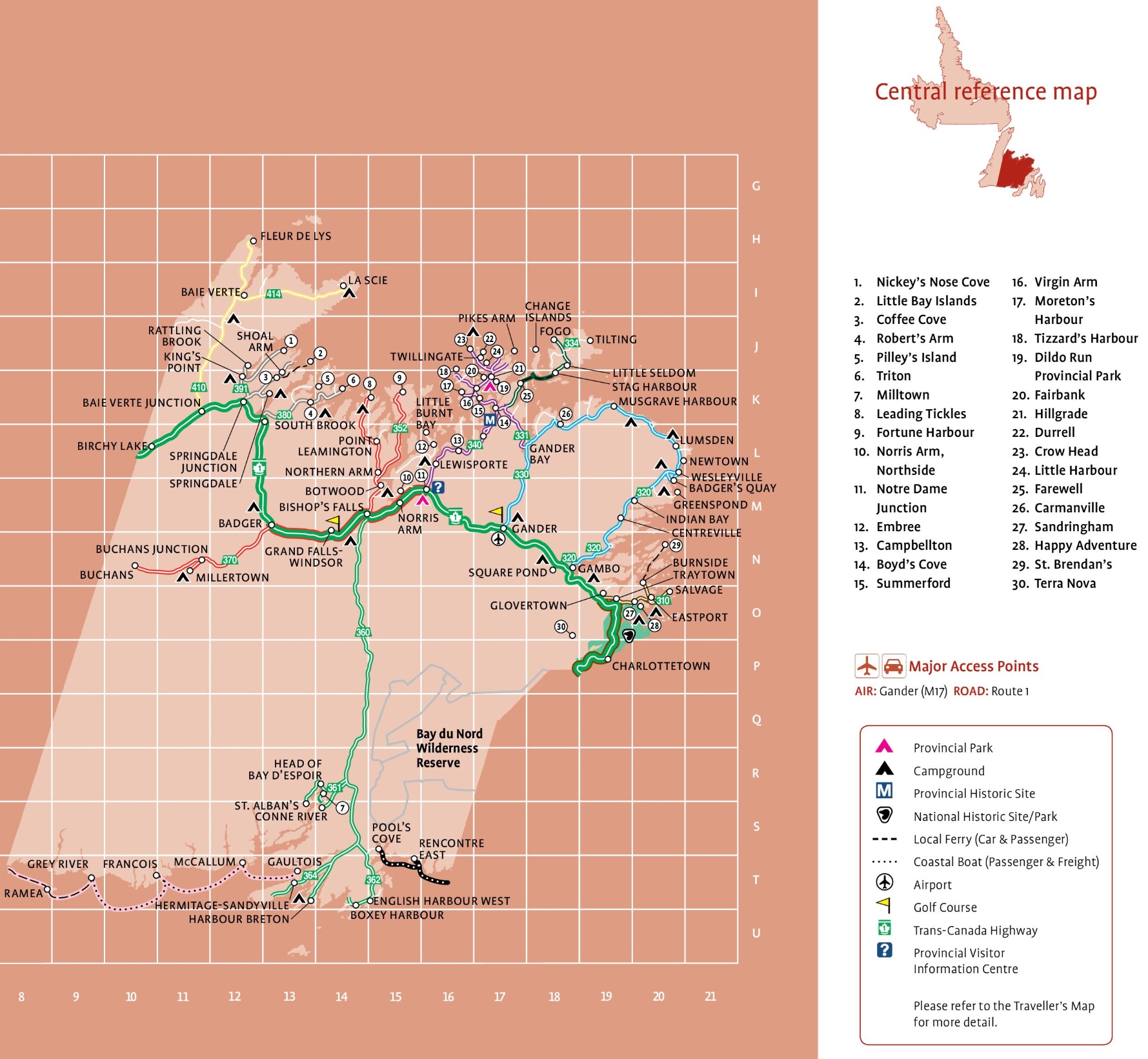
The Central Newfoundland tourist map, with dimensions of 1779×1641 pixels, is a detailed guide to the region’s attractions and amenities. It features key locations such as Fleur de Lys, Baie Verte, and the Baie Verte Junction. The map highlights various communities, including Twillingate, Springdale, and Botwood, and points out significant natural sites like the Bay du Nord Wilderness Reserve. Symbols on the map indicate provincial parks, campgrounds, historic sites, airports, golf courses, and the Trans-Canada Highway, as well as local ferry and coastal boat services. This map is an invaluable resource for visitors looking to explore the rich cultural and natural landscape of Central Newfoundland.
Please visit this page for other map resources or Google Maps.
What can You Discover on the Central Newfoundland Tourist Map Above?
Central Newfoundland is a hidden gem, filled with scenic drives, stunning landscapes, and charming communities. While many visitors may gravitate towards the larger cities and national parks, plenty of small towns and villages offer unique experiences and natural beauty. Here are some of the towns and sites that are included on the Central Newfoundland tourist map:
- Nickey’s Nose Cove: This small fishing community is situated on the coast of Green Bay, surrounded by dramatic cliffs and stunning views. Visitors can explore the rugged coastline, go whale watching, or learn about the history of the area at the local museum.
- Little Bay Islands: This isolated island community is accessible only by ferry but offers visitors a chance to experience the area’s natural beauty. The island has several hiking trails, beaches, and a lighthouse offering panoramic views of the coastline.
- Coffee Cove: Located on the shores of Notre Dame Bay, Coffee Cove is a quiet fishing village with a beautiful sandy beach. Visitors can take a stroll along the shoreline, visit the local wharf, or explore the nearby hiking trails.
- Robert’s Arm: This town is located on the banks of the Exploits River, which is known for its world-class salmon fishing. Visitors can also explore the nearby hiking trails, take a boat tour, or visit the local museum to learn about the history of the area.
- Pilley’s Island: This island community is accessible by ferry and offers visitors a chance to experience the rugged beauty of Newfoundland’s coastline. Visitors can explore the island’s hiking trails, go bird watching, or learn about the history of the area at the local museum.
- Triton: This small town is known for its rich fishing history, and visitors can still see the traditional fishing stages that dot the coastline. The town also has several hiking trails, a sandy beach, and a local museum that showcases the area’s history.
- Milltown: This town is situated on the banks of the Exploits River and offers visitors a chance to experience the area’s natural beauty. Visitors can go fishing, explore the nearby hiking trails, or take a boat tour to see the local wildlife.
- Leading Tickles: This town is located on the shores of Notre Dame Bay and is known for its stunning coastal scenery. Visitors can explore the nearby hiking trails, go whale watching, or learn about the history of the area at the local museum.
- Fortune Harbour: This small fishing community is located on the north coast of Notre Dame Bay and offers visitors a chance to experience the traditional Newfoundland way of life. Visitors can explore the local wharf, go fishing, or take a boat tour to see the local wildlife.
- Norris Arm, Northside: This town is located on the banks of the Exploits River and is known for its world-class salmon fishing. Visitors can also explore the nearby hiking trails, take a boat tour, or visit the local museum to learn about the history of the area.
- Notre Dame Junction: This small town on the Trans-Canada Highway offers visitors a chance to experience the area’s natural beauty. Visitors can explore the nearby hiking trails, go fishing, or take a scenic drive through the surrounding countryside.
- Embree: This small town is located on the shores of Notre Dame Bay and offers visitors a chance to experience the traditional Newfoundland way of life. Visitors can explore the local wharf, go fishing, or take a boat tour to see the local wildlife.
- Campbellton: This town is located on the banks of the Exploits River and is known for its world-class salmon fishing. Visitors can also explore the nearby hiking trails, take a boat tour, or visit the local museum to learn about the history of the area.
- Boyd’s Cove is a small community located on the eastern coast of Notre Dame Bay. It is home to the Beothuk Interpretation Centre, which offers a glimpse into the fascinating culture and history of the Beothuk people, the original inhabitants of Newfoundland. The center features exhibits, artifacts, and interactive displays, providing visitors with a unique insight into the lives of these indigenous people.
- Summerford is a picturesque town located on the shores of New World Island. The town is known for its stunning scenery, with rolling hills, pristine forests, and crystal-clear lakes. It is also home to the Summerford Municipal Park, a popular destination for camping, hiking, and outdoor activities. The park features a beautiful waterfall, picnic areas, and a playground, making it the perfect spot for a family day out.
- Virgin Arm is a small community located on the shores of Notre Dame Bay. The town is known for its stunning natural beauty, with rugged coastlines, pristine forests, and crystal-clear lakes. It is also home to the Virgin Arm Nature Park, a popular destination for hiking, camping, and wildlife viewing. The park features scenic trails, picnic areas, and a variety of wildlife, including moose, caribou, and black bears.
- Moreton’s Harbour is a small fishing community located on the northeastern coast of Notre Dame Bay. The town is known for its historic charm, with well-preserved heritage homes and buildings dating back to the early 1900s. It is also home to Moreton’s Harbour Heritage Society, which preserves and promotes the town’s rich cultural heritage through exhibits, events, and educational programs.
- Tizzard’s Harbour is a small fishing community located on the northeastern coast of Notre Dame Bay. The town is known for its rugged natural beauty, with rocky coastlines, pristine forests, and crystal-clear lakes. It is also home to the Tizzard’s Harbour Nature Park, a popular destination for hiking, camping, and wildlife viewing. The park features scenic trails, picnic areas, and a variety of wildlife, including moose, caribou, and black bears.
- Dildo Run Provincial Park is a beautiful park located on the eastern coast of Notre Dame Bay. The park features stunning scenery, with rolling hills, pristine forests, and crystal-clear lakes. It is also home to the Dildo Run Trail, a popular hiking trail that winds through the park’s rugged wilderness. The trail offers stunning views of the surrounding landscape, with opportunities for wildlife viewing and birdwatching.
- Fairbank Provincial Park is a small park located on the western coast of Notre Dame Bay. The park features stunning natural beauty, with rugged coastlines, pristine forests, and crystal-clear lakes. It is also home to the Fairbank Trail, a popular hiking trail that winds through the park’s wilderness. The trail offers stunning views of the surrounding landscape, with opportunities for wildlife viewing and birdwatching.
- Hill grade is a small community located on the eastern coast of Notre Dame Bay. The town is known for its stunning natural beauty, with rolling hills, pristine forests, and crystal-clear lakes. It is also home to the Hillgrade Recreation Park, a popular destination for camping, hiking, and outdoor activities. The park features scenic trails, picnic areas, and a playground, making it the perfect spot for a family day out.
- Durrell: Durrell is a small community located on the northeastern coast of Newfoundland. This area is known for its stunning views of the ocean and rugged coastline. The town is home to a number of hiking trails and outdoor activities, including fishing and kayaking.
- Crow Head: Crow Head is a picturesque village located on the island of Twillingate. The town is famous for its stunning views of the ocean, lighthouses, and icebergs. Visitors can explore the many hiking trails in the area, including the popular Crow Head Trail, which offers breathtaking views of the coastline.
- Little Harbour: Little Harbour is a small fishing community on Newfoundland’s eastern coast. This area is known for its beautiful beaches and rugged coastline. Visitors can explore the town’s fishing heritage, enjoy the local seafood, or go hiking in the nearby hills.
- Farewell: Farewell is a small town on Newfoundland’s eastern coast. This area is known for its stunning views of the ocean and rugged coastline. Visitors can explore the nearby hiking trails, including the popular Cape Freels Trail, which offers breathtaking views of the coastline.
- Carmanville: Carmanville is a small community on Newfoundland’s eastern coast. This area is known for its beautiful beaches and rugged coastline. Visitors can enjoy the local seafood, go hiking in the nearby hills or explore the town’s fishing heritage.
- Sandringham: Sandringham is a small community on Newfoundland’s eastern coast. This area is known for its stunning views of the ocean and rugged coastline. Visitors can explore the nearby hiking trails, including the popular Cape Freels Trail, which offers breathtaking views of the coastline.
- Happy Adventure: Happy Adventure is a small community on Newfoundland’s eastern coast. This area is known for its beautiful beaches and rugged coastline. Visitors can enjoy the local seafood, go hiking in the nearby hills, or explore the town’s fishing heritage.
- St. Brendan’s: St. Brendan’s is a small community on Newfoundland’s northern coast. This area is known for its stunning views of the ocean and rugged coastline. Visitors can explore the nearby hiking trails, enjoy the local seafood, or go fishing in the nearby waters.
- Terra Nova: Terra Nova is a provincial park on Newfoundland’s eastern coast. This park is known for its stunning views of the ocean, hiking trails, and wildlife. Visitors can camp in the park, go hiking or kayaking, or simply enjoy the area’s natural beauty.
Overall, the Central Newfoundland tourist map offers a great way to explore this beautiful region of Canada. Whether you are interested in hiking, fishing, or simply enjoying the area’s natural beauty, there is something for everyone to enjoy. So why not plan your next adventure to Central Newfoundland today?
What are Tourist Maps Used For?
Tourist maps are essential tools for any traveler. They visually represent an area’s attractions, accommodations, and amenities, making it easier to plan your trip. With a tourist map, you can quickly locate campgrounds, hiking trails, historic sites, and other places of interest. Additionally, tourist maps often include helpful information such as local weather patterns, transportation options, and nearby restaurants.
Did You Know About Central Newfoundland?
Central Newfoundland is known for its stunning natural beauty and rich cultural heritage. Here are a few interesting facts about the region:
- The Beothuk were the original inhabitants of Newfoundland and Labrador, and Central Newfoundland was one of their primary hunting grounds.
- The Exploits River in Central Newfoundland is one of the largest rivers in Atlantic Canada and is renowned for its salmon fishing.
- The Terra Nova National Park is located in Central Newfoundland and is home to abundant wildlife, including moose, caribou, and black bears.
- The town of Gander played a critical role in the history of aviation. During World War II, it was a stopover point for transatlantic flights, and in 2001, it became the site of a temporary airport following the 9/11 terrorist attacks.
Scenic Routes in Central Newfoundland
One of the best ways to explore Central Newfoundland is by taking one of its scenic driving routes. Here are some of the routes included on the tourist map:
- Dorset Trail: This 281 km one-way route takes you through rugged terrain and past the 1,500-year-old Dorset soapstone quarry at Fleur de Lys.
- Green Bay and the Beothuk Trail: Follow the 136 km one-way trail along the shores and islands of Notre Dame Bay, which was once the main hunting ground for the Beothuk people.
- Exploits Valley: This 261 km one-way route takes you through stunning scenery and past some of the best salmon fishing spots in Atlantic Canada.
- Coast of Bays: Explore the fjords and inlets of this 357 km one-way route, named “Bay of Hope” by the French settlers who once lived there.
- Kittiwake Coast: Road to the Beaches: Take the 41 km one-way route to Eastport on Bonavista Bay, a land of sand castles and sandpipers.
Conclusion
Central Newfoundland is a beautiful region with much to offer visitors. Whether you’re interested in outdoor activities, historic sites, or cultural attractions, this tourist map will help you easily plan your trip. With its comprehensive information on cities, towns, national parks, and scenic driving routes, you will have an unforgettable experience in Central Newfoundland.