Located on the eastern coast of Canada, Avalon is a beautiful region filled with charming cities, historic landmarks, and breathtaking natural wonders. From the picturesque fishing villages of the Irish Loop to the rugged coastal trails of Cape Spear, there’s something for everyone to enjoy in Avalon. To help visitors navigate this stunning region, we’ve created a comprehensive tourist map highlighting all the must-see destinations, including cities, towns, highways, parks, campgrounds, and much more. This blog post will look at what this map offers and share some exciting facts about Avalon.
Avalon Tourist Map
This map shows cities, towns, Trans-Canada highways, secondary roads, national parks, provincial parks, campgrounds, provincial/national historic sites, airports, local ferries, summer ferries, ski areas, golf courses, and provincial visitor information centers in Avalon.
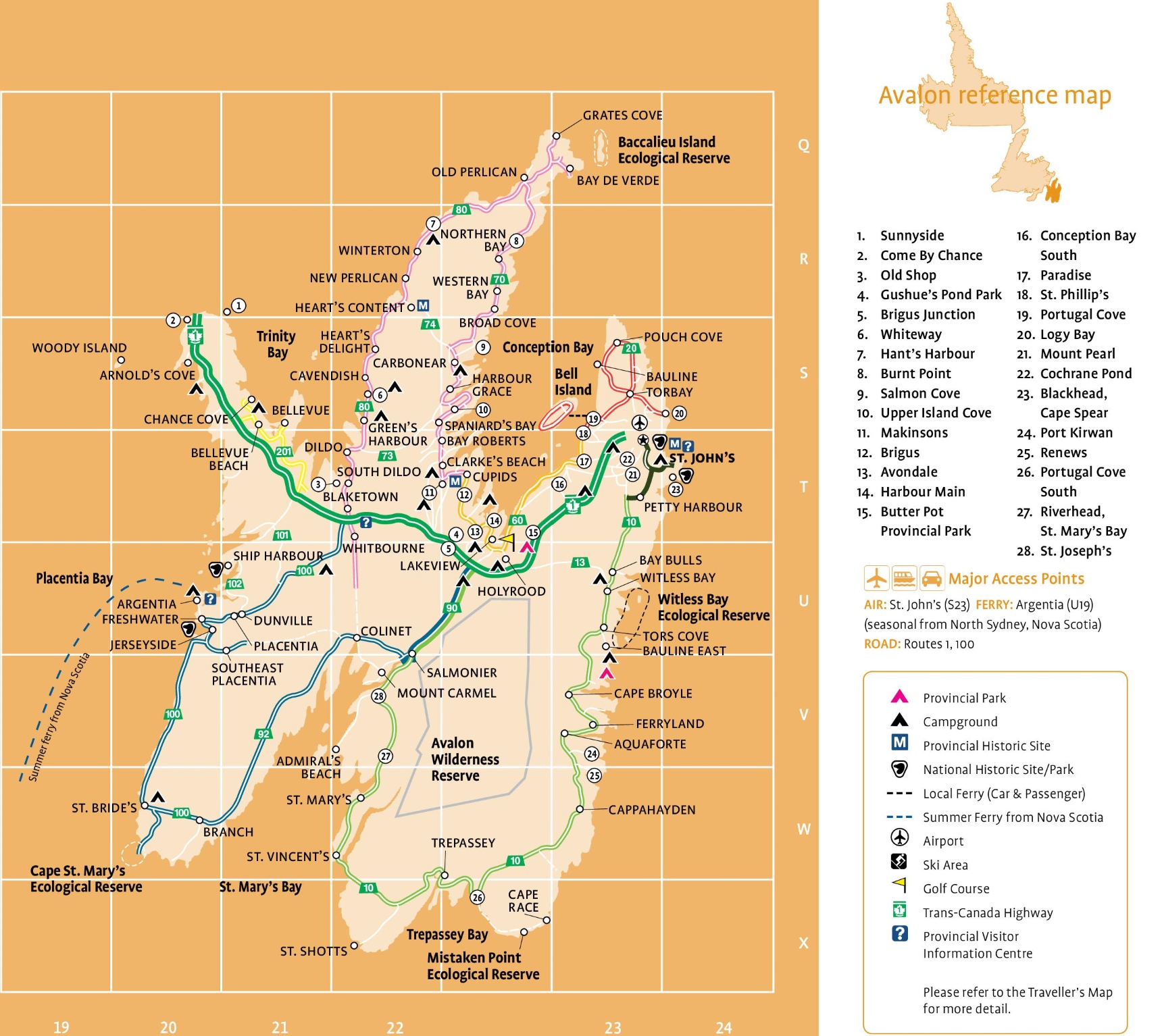
The Avalon Tourist Map, with dimensions of 1720×1534 pixels, is a comprehensive guide to the Avalon Peninsula in Newfoundland and Labrador. It highlights key locations and attractions such as the Baccalieu Island Ecological Reserve, the historic towns of Old Perlican and Bay de Verde, and the scenic coastal communities of Winterton and Heart’s Content. The map also features the Witless Bay Ecological Reserve, known for its puffin colonies, and the Cape St. Mary’s Ecological Reserve, a haven for birdwatchers. Additionally, it marks the Mistaken Point Ecological Reserve, a UNESCO World Heritage Site famous for its fossil beds. With symbols for provincial parks, historic sites, ferry routes, airports, ski areas, and golf courses, this map is an invaluable resource for visitors exploring the Avalon Peninsula’s rich natural and cultural heritage.
Please visit this page for other map resources or Google Maps.
What’s this tourist map of Avalon showing?
- Sunnyside: Sunnyside is a small town on the eastern side of the Avalon Peninsula. It is known for its beautiful scenery, with the town overlooking the ocean and rugged coastline. Sunnyside is also home to a famous beach, attracting locals and tourists during summer.
- Come By Chance: Come By Chance is a town located on the western side of the Avalon Peninsula, near the border with the neighboring province of Nova Scotia. The town is named after a nearby bay, a popular spot for sailors to anchor and restock supplies. Today, Come By Chance is known for its oil refinery, one of the country’s largest.
- Old Shop: Old Shop is a small community on the eastern side of the Avalon Peninsula, near Sunnyside. The community is known for its scenic beauty, with the surrounding hills providing stunning ocean and coastline views.
- Gushue’s Pond Park: Gushue’s Pond Park is beautiful in Mount Pearl. The park features a large pond, walking trails, and picnic areas, making it a popular spot for locals and tourists alike to enjoy the outdoors.
- Brigus Junction: Brigus Junction is a small community on the western side of the Avalon Peninsula, near Brigus. The community is known for its beautiful scenery, with nearby lakes and forests providing hiking, fishing, and camping opportunities.
- Whiteway is a small town on the Avalon Peninsula’s eastern side. The town is known for its scenic beauty, with rugged coastlines and rolling hills providing stunning views of the surrounding area.
- Hant’s Harbour: Hant’s Harbour is a small town on the Avalon Peninsula’s eastern side. The town is known for its historic buildings and beautiful scenery, with the surrounding hills providing stunning views of the ocean and coastline.
- Burnt Point: Burnt Point is a small community on the eastern side of the Avalon Peninsula, near Whiteway. The community is known for its scenic beauty, with rugged coastlines and rolling hills providing stunning views of the surrounding area.
- Salmon Cove: Salmon Cove is a small town on the Avalon Peninsula’s eastern side. The town is known for its beautiful scenery, with nearby beaches and rolling hills providing hiking, fishing, and camping opportunities.
- Upper Island Cove: Upper Island Cove is a small town on the Avalon Peninsula’s eastern side. The town is known for its scenic beauty, with rugged coastlines and rolling hills providing stunning views of the surrounding area.
- Makinsons: Makinsons is a small community on the eastern side of the Avalon Peninsula, near Bay Roberts. The community is known for its historic buildings and beautiful scenery, with the surrounding hills providing stunning views of the ocean and coastline.
- Brigus is a historic town on the Avalon Peninsula’s eastern side. The town is known for its well-preserved architecture and historic sites, including the Hawthorne Cottage National Historic Site and the Brigus Tunnel.
- Avondale: Avondale is a small town on the Avalon Peninsula’s eastern side. The town is known for its beautiful scenery, with nearby rivers and forests providing opportunities for fishing and hiking.
- Harbour Main: Harbour Main is a small town on the Avalon Peninsula’s eastern side. The town is known for its historic buildings and beautiful scenery, with the surrounding hills providing stunning views of the ocean and coastline.
- Butter Pot Provincial Park: Butter Pot Provincial Park is off the Trans-Canada Highway between Holyrood and Gushue’s Pond. The park is known for its rugged terrain, which makes it a popular spot for hiking, camping, and birdwatching. Visitors can hike one of the many trails, including the 10km Butter Pot Hill Trail, which offers stunning views of the surrounding area. Several campsites are also available, including walk-in sites and sites for RVs.
- Conception Bay South: Conception Bay South is a vibrant town on the southern shore of Conception Bay. The town is known for its scenic beauty and rich history, and it’s a popular spot for outdoor activities such as hiking, fishing, and boating. Visitors can explore the town’s historic sites, including the Conception Bay Museum, which exhibits the area’s history and culture. The town is also home to several restaurants, cafes, and shops.
- Paradise: Paradise is a town located just west of St. John’s. The town is known for its beautiful scenery, friendly people, and rich history. Visitors can explore the town’s many parks and walking trails, including Neil’s Pond Trail, which offers stunning views of the area’s natural beauty. Paradise is also home to several restaurants, cafes, and shops, and it’s a great place to base yourself while exploring the Avalon Peninsula.
- St. Phillip’s: St. Phillip’s is a small community on the eastern shore of Conception Bay. The community is known for its scenic beauty and rich history, and it’s a popular spot for hiking, fishing, and boating. Visitors can explore the community’s historic sites, including the Old St. Phillip’s Anglican Church, built in 1847. St. Phillip’s is also home to several parks and walking trails, including the Biscan Cove Path, which offers stunning coastline views.
- Portugal Cove: Portugal Cove is a historic community outside St. John’s. The community is known for its beautiful scenery and rich history, and it’s a popular spot for hiking, fishing, and boating. Visitors can explore the community’s historic sites, including the Portugal Cove Heritage Museum, which exhibits the area’s history and culture. Portugal Cove is also home to several parks and walking trails, including the Beaches Path, which offers stunning coastline views.
- Logy Bay: Logy Bay is a small community north of St. John’s. The community is known for its beautiful scenery and rich history, and it’s a popular spot for hiking, fishing, and boating. Visitors can explore the community’s historic sites, including the Johnson Geo Centre, which exhibits the area’s geology and history. Logy Bay is also home to several parks and walking trails, including the East Coast Trail, which offers stunning coastline views.
- Mount Pearl: Mount Pearl is a bustling suburb just west of St. John’s. The city is known for its friendly people and family-friendly atmosphere. Visitors can explore the city’s many parks and walking trails, including the Mount Pearl Trailway, which offers stunning views of the area’s natural beauty. Mount Pearl is also home to several restaurants, cafes, and shops, and it’s a great place to base yourself while exploring the Avalon Peninsula.
- Cochrane Pond: Located on the western edge of the Avalon Peninsula, Cochrane Pond is a popular destination for outdoor enthusiasts. The pond is known for its excellent fishing opportunities, particularly for trout and salmon. The area also has several hiking trails, allowing visitors to explore the scenic wilderness and enjoy stunning views of the pond and surrounding landscape.
- Blackhead/Cape Spear: Blackhead and Cape Spear are two adjacent communities located at the southeastern tip of the Avalon Peninsula. Cape Spear is home to the Cape Spear Lighthouse National Historic Site, the most easterly point in North America. The site is a popular attraction, and visitors can explore the lighthouse and the surrounding trails while taking in breathtaking views of the rugged coastline and the Atlantic Ocean.
- Port Kirwan: Port Kirwan is a small fishing community located on the southeastern coast of the Avalon Peninsula. The community is home to a historic church and several hiking trails, which allow visitors to explore the rugged coastline and enjoy stunning views of the Atlantic Ocean.
- Renews: Renews is a picturesque fishing village on the Avalon Peninsula’s southern shore. The village is home to several historic sites, including the historic Holy Trinity Church and several restored homes from the 19th century. Visitors can stroll through the village and explore the scenic coastline, home to various seabirds and marine life.
- Portugal Cove South: Portugal Cove South is a small community on the Avalon Peninsula’s southern coast. The community is known for its scenic beauty and offers visitors the opportunity to explore the rugged coastline, hike through the wilderness, and relax on the beach. The area also has several historic sites, including the historic Portugal Cove South Church and several restored homes from the 19th century.
- Riverhead, St. Mary’s Bay: Riverhead is a small community located on the eastern shore of St. Mary’s Bay, just off the Trans-Canada Highway. The community is known for its stunning scenery and offers visitors the opportunity to explore the rugged coastline, hike through the wilderness, and relax on the beach. The area also has several historic sites, including the historic St. Joseph’s Church and several restored homes from the 19th century.
- St. Joseph’s: St. Joseph’s is a small community on the eastern shore of St. Mary’s Bay, just off the Trans-Canada Highway. The community is known for its stunning scenery and offers visitors the opportunity to explore the rugged coastline, hike through the wilderness, and relax on the beach. The area also has several historic sites, including the historic St. Joseph’s Church and several restored homes from the 19th century.
In conclusion, the Avalon Tourist Map is an invaluable resource for visitors to the Avalon Peninsula. Whether you are interested in exploring historic sites, hiking through wilderness areas, or simply relaxing on the beach, this map will help you plan your visit and ensure you don’t miss any of the area’s top attractions. With its detailed information about cities, towns, highways, parks, campgrounds, and other points of interest, the Avalon Tourist Map is a must-have for anyone planning a trip to this beautiful part of Canada.
What are such Tourist Maps Used For?
Tourist maps are a valuable resource for travelers who want to explore a new area or plan a road trip. They provide an overview of the region, highlight the most popular attractions, and offer information about local services and amenities. With a good tourist map, you can easily find your way around, discover hidden gems, and make the most of your time in a new place.
Did you know about Avalon?
Avalon is a region steeped in history, culture, and natural beauty. Here are some interesting facts about Avalon that you may not have known:
- Avalon is named after the legendary island of Arthurian lore, which was said to be the final resting place of King Arthur.
- The region is home to the oldest continuous European settlement in North America, with the first settlers arriving from England in 1610.
- Cape Spear, located on the easternmost point of North America, is the site of the oldest surviving lighthouse in Newfoundland and Labrador, which has operated since 1836.
- The Witless Bay Ecological Reserve, located south of St. John’s, is the largest puffin colony in North America, with over 260,000 breeding pairs.
- The town of Brigus is famous for being the childhood home of Captain Bob Bartlett, a legendary Arctic explorer who led expeditions to the North Pole and the Arctic Ocean.
Exploring Avalon with Our Tourist Map Our Avalon tourist map is designed to help visitors make the most of their time in the region. Here are some of the critical features of our map:
Cities and Towns: Our map highlights all the major cities and towns in Avalon, including St. John’s, Conception Bay South, and Carbonear.
Highways and Roads: The map shows the region’s major highways and secondary roads, making planning a road trip or navigating between destinations easy.
Parks and Campgrounds: Avalon is home to some of the most beautiful national and provincial parks in Canada, including Cape Spear Lighthouse National Historic Site, Signal Hill National Historic Site, and Terra Nova National Park. Our map includes all the major parks and campgrounds in the region.
Historic Sites: From the historic district of downtown St. John’s to the many museums and heritage sites throughout the region, Avalon is rich in history and culture. Our map highlights all the major historic sites in the region, including Castle Hill National Historic Site, The Rooms, and the Cupids Cove Plantation.
Airports and Ferries: Our map shows all the region’s major airports and ferry terminals if you’re arriving in Avalon by air or sea.
Ski Areas and Golf Courses: Whether you’re looking to hit the slopes or the fairways, Avalon has plenty of options for outdoor recreation. Our map includes all the region’s major ski areas and golf courses.
Visitor Information Centers: Our map includes all of Avalon’s major visitor information centers, including provincial and national centers. These centers offer a wealth of information on the region’s history, culture, and natural wonders, as well as maps and brochures to help you plan your trip. The friendly staff at these centers can also advise where to go, what to see, and where to stay in the region.
Summer Ferries: Avalon is surrounded by the Atlantic Ocean, and there’s no better way to experience the region’s rugged coastline and beautiful islands than by taking a summer ferry. Our map includes all the major summer ferry routes in Avalon, including those to Bell Island, Fogo Island, and Witless Bay.
Conclusion
Whether you’re a history buff, a nature lover, or simply looking for a beautiful place to explore, Avalon has something for everyone. Our tourist map is the perfect tool to help you plan your trip and discover all this stunning region offers. So grab a copy of our map, hit the road, and explore Avalon today!