Labrador is a vast and breathtaking region in Canada, known for its rugged natural beauty, diverse wildlife, and fascinating cultural heritage. To explore this stunning destination, there’s no better way than hitting the open road and embarking on a scenic driving adventure. That’s where our Labrador Scenic Driving Routes Map comes in, helping you navigate through the region’s cities, towns, trails, parks, historic sites, and more. In this blog post, we’ll examine the map’s features and how it can help you plan your next adventure in Labrador.
Labrador Scenic Driving Routes Map
This map shows Labrador’s cities, towns, trails, roads, national parks, provincial parks, provincial visitor information centers, provincial/national historic sites, ferries, and airports.
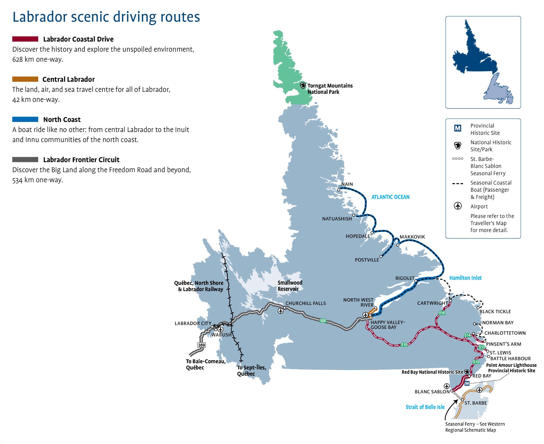
The Labrador Scenic Driving Routes map, with dimensions of 1893×1547 pixels, offers a guide to the unique driving experiences in the region. It includes:
- Labrador Coastal Drive: A 628 km journey to discover history and explore the pristine environment.
- Central Labrador: A 42 km route that serves as the land, air, and sea travel center for all of Labrador.
- North Coast: A boat ride from central Labrador to the Inuit and Innu communities of the north coast.
- Labrador Frontier Circuit: A 534 km adventure along the Freedom Road and beyond into the vast landscapes of Labrador.
The map also marks important landmarks like the Point Amour Lighthouse and the Red Bay National Historic Site, as well as travel essentials such as airports and ferry services. It’s a valuable resource for those looking to venture into the rugged beauty of Labrador.
Please visit this page for other map resources or Google Maps.
What are Scenic Driving Routes Visible on the Map of Labrador?
Labrador, the easternmost region of Canada, is a vast and breathtaking destination that offers visitors an unforgettable experience of rugged natural beauty, diverse wildlife, and fascinating cultural heritage. The region is home to many scenic driving routes that allow travelers to explore its many cities, towns, trails, parks, historic sites, and more. Among these, the Labrador Scenic Driving Routes Map features four significant routes that showcase the region’s most impressive attractions. Here’s a closer look at each of them:
Labrador Coastal Drive
The Labrador Coastal Drive is a 628-km one-way route that takes visitors along the rugged coastline of the Labrador Peninsula. This scenic drive offers an opportunity to explore the region’s history, including the Viking settlement of L’Anse aux Meadows, a UNESCO World Heritage Site, and Red Bay Basque Whaling Station, a National Historic Site. Travelers can also enjoy the unspoiled environment and unique wildlife, including whales, seabirds, and caribou. The route starts in the town of L’Anse-au-Clair and ends in the community of Red Bay.
Central Labrador
Central Labrador is the land, air, and sea travel center for all of Labrador, featuring a 42-km one-way scenic drive that takes visitors through the region’s heart. The route offers breathtaking views of the surrounding wilderness, including forests, lakes, and rivers. Along the way, travelers can stop at many provincial parks and historic sites, including Menihek Nordic Ski Club, Churchill Falls, and the Labrador Heritage Society Museum. The route starts in Happy Valley-Goose Bay and ends in the community of North West River.
North Coast
The North Coast is a boat ride, taking travelers from central Labrador to the Inuit and Innu communities of the north coast. The 12-hour journey along the scenic coastline is an unforgettable experience that allows visitors to see the region’s unique wildlife, including polar bears, seals, and whales. Along the way, travelers can explore the Inuit and Innu cultures and learn about their traditional way of life. The route starts in Happy Valley-Goose Bay and ends in the community of Nain.
Labrador Frontier Circuit
The Labrador Frontier Circuit is a 534-km one-way route that takes visitors to discover the Big Land along the Freedom Road and beyond. The route offers breathtaking views of the region’s rugged wilderness, including forests, mountains, and lakes. Along the way, travelers can explore many historic sites, including the Mealy Mountains National Park Reserve and the Red Bay Basque Whaling Station. The route starts in the town of Goose Bay and ends in the community of Cartwright.
Whether you’re interested in exploring Labrador’s history, culture, wildlife, or natural beauty, these four scenic driving routes have something for everyone. With the Labrador Scenic Driving Routes Map, you can plan you’re itinerary and make the most of your adventure in this stunning part of Canada. From the rugged coastline to the heart of the wilderness, Labrador’s scenic drives are an unforgettable experience that will leave you with lasting memories. So, get ready to hit the open road and discover the natural beauty of Labrador.
What are Scenic Driving Routes Maps used for?
Scenic driving route maps are an essential tool for any road trip enthusiast. These maps highlight the best roads, highways, and byways for enjoying a region’s natural beauty, cultural attractions, and historic sites. The Labrador Scenic Driving Routes Map is designed to help you discover the most scenic and rewarding routes for exploring this beautiful part of Canada.
Did you know about Canada?
Labrador is one of North America’s last untamed wilderness areas, offering visitors a chance to experience the raw natural beauty and explore fascinating cultural heritage. Here are some interesting facts about Labrador that you might not know:
- Labrador is part of the province of Newfoundland and Labrador, located on the eastern coast of Canada. It covers an area of 294,000 square kilometers, making it larger than 36 of the 50 U.S. states.
- Labrador is home to three distinct Aboriginal cultures: the Innu, Inuit, and Metis. Each has a rich history and unique traditions that have shaped the region’s culture and identity.
- The region is known for its rugged natural beauty, including vast forests, winding rivers, and towering mountains. It’s also home to the world’s largest caribou herds and other wildlife species like black bears, moose, and wolves.
- Labrador is a popular destination for outdoor enthusiasts, offering a range of activities such as hiking, kayaking, fishing, and hunting. The region also boasts several provincial parks and national historic sites, including the Red Bay Basque Whaling Station, a UNESCO World Heritage Site.
- Labrador has a rich mining history and is home to several world-class mining operations, including the Iron Ore Company of Canada and the Voisey’s Bay Nickel Company.
Conclusion
If you’re planning a road trip to Labrador, our Scenic Driving Routes Map is essential for making the most of your adventure. With its detailed information on cities, towns, trails, roads, national parks, provincial parks, visitor information centers, historic sites, ferries, and airports, you’ll have everything you need to plan the perfect itinerary. Labrador has something for everyone, whether you’re interested in exploring the region’s natural beauty, cultural heritage, or outdoor adventures.