The Northwest Territories is a land of vast wilderness and spectacular natural beauty, with plenty of outdoor adventures and exploration opportunities. However, with so much to see and do, it can be challenging to plan your itinerary and navigate your way around the region. That’s where a comprehensive tourist map comes in handy. In this blog post, we’ll look at what this particular tourist map offers and how it can help you plan your trip to the Northwest Territories.
Northwest Territories Tourist Map
This map shows cities, towns, rivers, lakes, heritage rivers, Trans-Canada trail, paved surface, unpaved surface, dumpster highways, canol hiking routes, Ingraham trails, liard trails, frontier trails, great slave routes, waterfalls routes, wood buffalo routes, ferries, historical sites, day use parks, national parks, diamond mines, and visitor information centers.
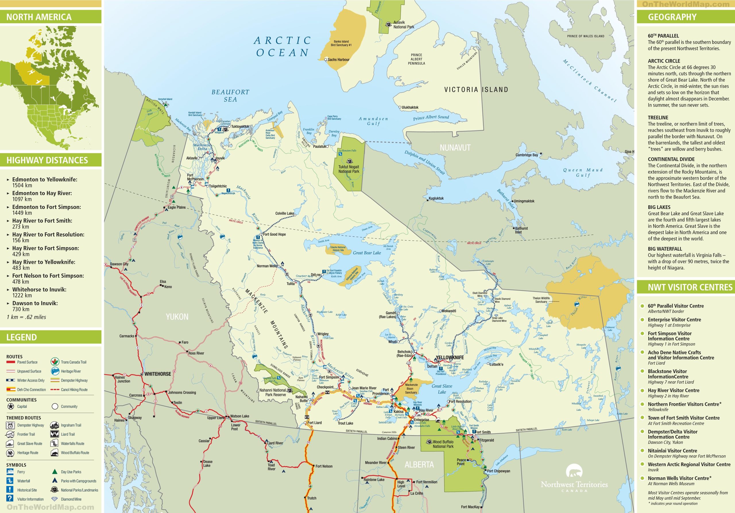
The Northwest Territories tourist map, with dimensions of 2560×1785 pixels, is a detailed guide that showcases the region’s vast landscapes and points of interest. It highlights the 60th parallel, which marks the southern boundary of the territory, and the Arctic Circle, which cuts through the northern shore of Great Bear Lake. The map also outlines the treeline, the Continental Divide, and the big lakes of the region, including Great Bear Lake and Great Slave Lake. Notable features, such as the highest waterfall, Virginia Falls, are also marked. The map provides highway distances between key locations, visitor center locations, and themed routes like the Dempster Highway and Waterfalls Route. Symbols indicate visitor centers, parks, campgrounds, national parks, and landmarks, making it an invaluable tourist resource.
Please visit this page for other map resources or Google Maps.
What This Tourist Map Offers
This tourist map of the Northwest Territories is a treasure trove of information for any visitor, offering more than just a land layout. It serves as a gateway to this northern Canadian expanse’s natural wonders and cultural heritage. The map meticulously marks the major cities and towns, providing a sense of community amidst the vast wilderness. The intricate web of rivers and lakes charted here is a testament to the region’s natural beauty and a guide for water-based adventures, from serene paddling excursions to thrilling fishing trips.
Heritage rivers and waterfall routes like the majestic Virginia Falls, with a drop exceeding Niagara’s, beckon the intrepid explorer. For those inclined towards terrestrial treks, the map delineates various hiking trails, such as the historic Canol Hiking Route, which traces a World War II pipeline, and the Trans-Canada Trail, offering a cross-country journey through diverse landscapes.
The Dempster Highway, a route of raw beauty stretching into the Arctic, is highlighted, as are the Ingraham and Liard Trails, each promising unique vistas and experiences. The Frontier and Great Slave Routes glimpse the region’s pioneering spirit and trading history.
The map’s practical details include indications of paved and unpaved surfaces, essential for planning road trips in remote areas where road conditions can significantly impact travel. Ferry routes are marked, providing crucial links across the territory’s vast waterways. For those interested in the economic heartbeat of the region, the diamond mines are a sparkling addition, symbolizing the territory’s rich resources.
Visitor information centers are pinpointed, serving as oases of local knowledge and assistance. Day-use and national parks are clearly marked, inviting visitors to partake in the natural splendor, whether for a picnic or a camping adventure.
In sum, this map is not merely a navigational tool; it’s a comprehensive companion for any journey through the Northwest Territories, offering insights into the land’s geography, ecology, history, and the many adventures that await.
Heritage and Historical Sites
For those interested in the history and culture of the region, the map also shows the location of various heritage and historical sites, making it easy to plan a tour and learn more about the rich cultural heritage of the Northwest Territories.
Hotels, Resorts, and Other Points of Interest: For those looking for accommodations, the tourist map also shows the location of hotels, resorts, and other points of interest, making it easy to plan an itinerary and get the most out of your visit to the Northwest Territories.
Diamond Mines and Historical Sites
For those interested in learning more about the region’s history and culture, the tourist map highlights various diamond mines and historical sites. These are an excellent way to learn about the rich cultural heritage of the Northwest Territories and gain insight into the lives of its inhabitants.
Did You Know About the Northwest Territories?
- The Northwest Territories is home to over 30,000 lakes, including the Great Bear Lake, the eighth-largest lake in the world.
- The region has several diamond mines, including the Diavik and Ekati Diamond Mine.
- The Northwest Territories is known for its stunning natural beauty, including the Northern Lights, visible from September to April.
- The region is home to several unique and endangered species, including the woodland caribou and the polar bear.
Conclusion
Exploring the Northwest Territories is an adventure of a lifetime, and having a comprehensive tourist map can help you make the most of your visit. The map on canadamaps.com is an excellent resource for anyone planning a trip to the region. It shows all the major cities and towns, transportation routes, heritage rivers, trails, waterfalls, diamond mines, historical sites, and other points of interest, making it easy to plan an itinerary and navigate your way around this stunning part of Canada.