Welcome to CanadaMaps.com, your go-to source for discovering the beautiful country of Canada. This post will take you on a journey through the stunning province of Saskatchewan, with its vast and diverse landscapes, culture, and history. Whether a local or a first-time visitor, this sizeable detailed tourist map of Saskatchewan will be your ultimate guide to exploring the province’s cities, towns, parks, historic sites, and much more.
Large detailed tourist map of Saskatchewan with cities and towns
This map shows cities, towns, rivers, lakes, the Trans-Canada highway, major highways, secondary roads, winter roads, CANAM highway, northern woods, and water routes, the Saskota travel route, Veterans Memorial Highway, Red Coat Trail, Louis Riel trail, Chief Whitecap Trail, national parks, provincial parks, historic sites, ecological reserves, Indian reservations, regional parks, campgrounds, airports, ferries, tourism visitor reception centers and rest areas in Saskatchewan.
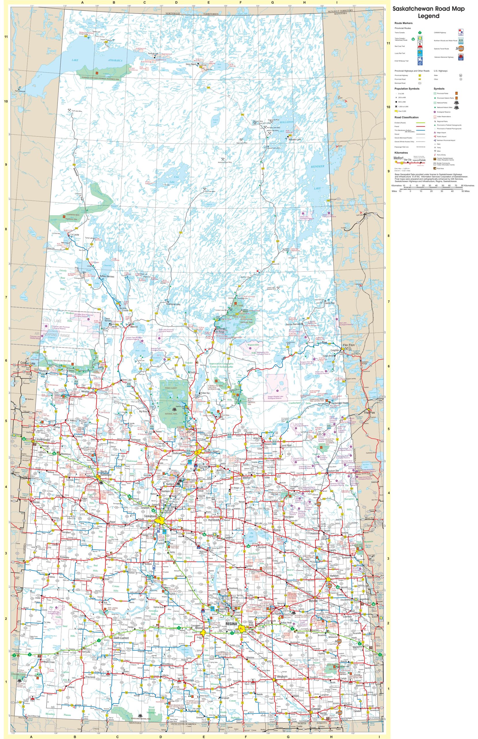
The tourist map of Saskatchewan with cities and towns is a detailed visual guide with a resolution of 1656×2560 pixels. It features a comprehensive layout of the province’s road network, including highways and secondary roads, as well as the locations of cities, towns, and points of interest. The map is designed to assist tourists in navigating Saskatchewan, providing a clear view of the province’s infrastructure and attractions, from the urban centers to the natural beauty of its rural areas.
Please visit this page for other map resources or Google Maps.
What are tourist maps used for?
Tourist maps are essential tools for planning and navigating travel itineraries. They provide a comprehensive view of a destination’s geography, landmarks, and attractions, allowing travelers to plan their routes and make informed decisions about their activities. Tourist maps also help visitors to explore a destination at their own pace, providing a sense of independence and adventure.
Did you know about Saskatchewan?
Saskatchewan is located in western Canada and is known for its prairies, forests, and lakes. It is the sixth-largest province in Canada by area, with a population of approximately 1.1 million people. Saskatchewan is also known for its agriculture, mining, and oil and gas industries, making it a vital contributor to the Canadian economy.
Now, let’s look at what this tourist map offers.
Features of the tourist map
Cities and Towns: The map highlights Saskatchewan’s cities and towns, including Regina, Saskatoon, Moose Jaw, and Prince Albert. This feature will help visitors navigate the province and find the nearest urban center for accommodation, dining, and entertainment.
Rivers, Lakes, and Highways: The map shows Saskatchewan’s major rivers, lakes, and highways, including the Trans-Canada Highway, CANAM Highway, and northern woods and water routes. This feature will help visitors plan their routes and explore Saskatchewan’s natural beauty.
Travel Routes: The map highlights various travel routes, including the Saskota Travel Route, Veterans Memorial Highway, Red Coat Trail, Louis Riel Trail, and Chief Whitecap Trail. These routes allow visitors to explore Saskatchewan’s cultural and historical landmarks.
Parks, Reserves, and Campgrounds: The map shows Saskatchewan’s national parks, provincial parks, historic sites, ecological reserves, Indian reservations, and regional parks. This feature will help visitors plan their camping and outdoor activities and learn about Saskatchewan’s rich history and culture.
Airports, Ferries, and Visitor Reception Centers: The map highlights Saskatchewan’s airports, ferries, and tourism visitor reception centers. This feature will help visitors plan transportation and access helpful travel resources.
Rest Areas: The map shows all of Saskatchewan’s rest areas, providing visitors with a convenient and safe place to take a break during their travels.
Conclusion
Saskatchewan is a beautiful and diverse province that offers something for everyone. Whether you are interested in exploring the natural beauty, learning about the history and culture, or simply relaxing and enjoying the scenery, this large, detailed tourist map of Saskatchewan will be your ultimate guide. So start planning your trip today and discover all that Saskatchewan offers.