The Yukon Territory is a vast and rugged region in northwestern Canada, home to some of the country’s most stunning natural landscapes. From the towering peaks of the St. Elias Mountains to the winding waterways of the Yukon River, there’s plenty to see and do in this remote and sparsely populated territory. However, with its vast size and challenging terrain, navigating the Yukon can be daunting, especially for those unfamiliar with the region’s highways and roadways. That’s where the Yukon Highway Map comes in.
The Yukon Highway Map
This detailed map provides a comprehensive view of the Yukon’s highways, main roads, secondary roads, and key natural features such as rivers, lakes, and national parks. With its user-friendly layout and easy-to-read design, the Yukon Highway Map is indispensable for anyone planning a road trip or exploring the territory’s many outdoor adventures.
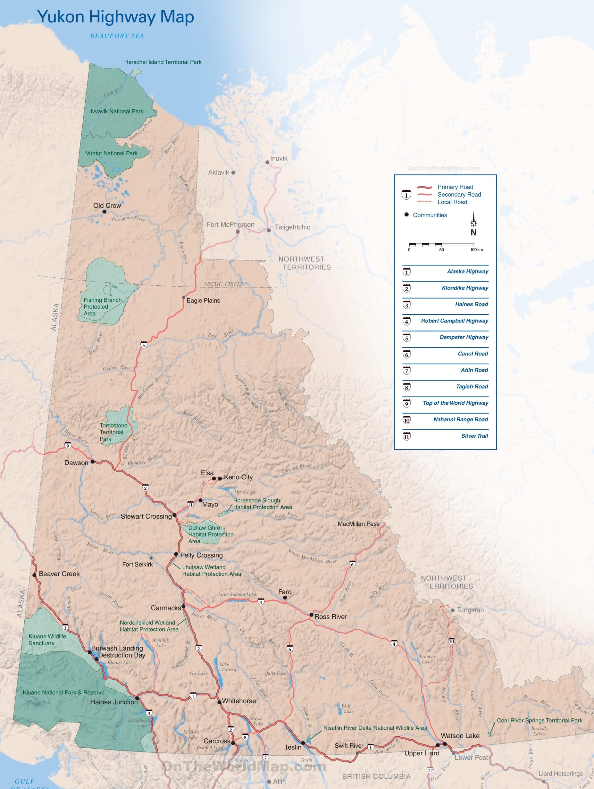
The Yukon Highway Map, with a resolution of 1929×2560 pixels, provides an intricate view of the territory’s road infrastructure. It details primary, secondary, and local roads, offering a clear guide for navigation across the region.
The map features key highways such as the iconic Alaska Highway, which cuts through the territory, connecting travelers to Alaska and British Columbia. The Klondike Highway, another vital route, links the capital, Whitehorse, to the historic town of Dawson City. The Haines Road offers a scenic drive to the coastal town of Haines in Alaska, while the Robert Campbell Highway connects the central Yukon communities.
For those seeking the path less traveled, the Dempster Highway stretches from the Klondike Highway near Dawson City to Inuvik in the Northwest Territories, traversing stunning tundra landscapes. The Canol Road, although less traveled, is steeped in history from the construction of the Canol pipeline during World War II.
The map also marks the Top of the World Highway, providing breathtaking views and a unique driving experience. The Nahanni Range Road and Silver Trail lead to more remote areas, revealing Yukon’s wild heart.
Communities such as Old Crow, accessible only by air or water, and Fort McPherson are noted, emphasizing the remote nature of living in the Yukon. The map also highlights natural attractions like the Liard Hotsprings, a popular stop along the Alaska Highway.
This map is an essential companion for anyone planning to explore the vast landscapes of Yukon by road, whether for adventure, sightseeing, or understanding the layout of this northern territory.
Please visit this page for other map resources or Google Maps.
Here are some of the critical features of the Yukon Highway Map:
- Major Highways: The map highlights the Yukon’s two major highways – the Alaska Highway and the Klondike Highway – and other vital roads such as the Haines Road and the Dempster Highway. These roads provide critical transportation links between Yukon’s communities and the rest of Canada and Alaska.
- Secondary Roads: Besides the major highways, the map also shows the Yukon’s network of secondary roads, which provide access to remote communities, natural attractions, and outdoor recreation areas.
- Natural Features: The Yukon is known for its stunning natural beauty, and the highway map helps visitors navigate some of the territory’s most iconic features, including the Yukon River, Kluane National Park, and the Tombstone Mountains.
- Border Crossings: The Yukon Highway Map provides information on the key border crossings and operating hours for those planning to cross the border into Alaska.
On the Yukon Highway Map above, you may discover Alaska Highway, Klondike Highway, Haines Road, Robert Campbell Highway, Dempster Highway, Canol Road, Atlin Road, Tagish Road, Top of the World Highway, Nahanni Range Road, and Silver Trail. Here’s some information about each of these highways and roads:
- Alaska Highway – The Alaska Highway is one of the most famous roads in North America, stretching from Dawson Creek, British Columbia, to Delta Junction, Alaska. The highway covers over 2,200 km (1,367 mi). It is known for its stunning scenery and historical significance, having been built during World War II to provide a military supply route to Alaska.
- Klondike Highway – The Klondike Highway runs from Skagway, Alaska, to Dawson City, Yukon, covering a distance of around 715 km (444 mi). The highway is named after the Klondike Gold Rush, which began in 1896 and brought thousands of prospectors to the Yukon in search of riches.
- Haines Road – The Haines Road is a scenic drive from Haines, Alaska, to Haines Junction, Yukon, covering a distance of around 244 km (152 mi). The road offers stunning views of the Coast Mountains and Kluane National Park and is a popular route for hikers and outdoor enthusiasts.
- Robert Campbell Highway – The Robert Campbell Highway runs from Carmacks, Yukon, to Watson Lake, Yukon, covering a distance of around 583 km (362 mi). The highway is named after Robert Campbell, a famous fur trader and explorer who helped to map the region in the 1800s.
- Dempster Highway – The Dempster Highway is a remote and rugged road that runs from Dawson City, Yukon, to Inuvik, Northwest Territories, covering a distance of around 736 km (457 mi). The highway is the only road in Canada that crosses the Arctic Circle and offers stunning views of the northern landscape.
- Canol Road – The Canol Road is a historic route that runs from Johnson’s Crossing, Yukon, to Norman Wells, Northwest Territories, covering a distance of around 355 km (220 mi). The road was built during World War II as part of a pipeline project to transport oil from Norman Wells to Whitehorse, but was never completed.
- Atlin Road – The Atlin Road runs from Carcross, Yukon, to Atlin, British Columbia, covering a distance of around 95 km (59 mi). The road offers stunning views of Atlin Lake and the surrounding mountains and is a popular route for outdoor enthusiasts.
- Tagish Road – The Tagish Road runs from Carcross, Yukon, to Tagish, Yukon, covering a distance of around 60 km (37 mi). The road offers stunning views of the Southern Lakes region and is a popular route for hiking, camping, and wildlife viewing.
- Top of the World Highway – The Top of the World Highway runs from Dawson City, Yukon, to the Alaska border, covering a distance of around 127 km (79 mi). The road offers stunning views of the surrounding mountains and valleys and is named for the panoramic views from its high-altitude vantage points.
- Nahanni Range Road – The Nahanni Range Road runs from Watson Lake, Yukon, to the Nahanni Range Road Reserve, covering a distance of around 193 km (120 mi). The road offers stunning views of the Nahanni Mountains and the surrounding wilderness and is a popular route for hikers and outdoor enthusiasts.
- Silver Trail – The Silver Trail runs from the Klondike Highway near Carmacks, Yukon, to the historic mining town of Keno City, Yukon, covering a distance of around 240 km (149 mi). The road passes through some of the Yukon’s most scenic and historic areas and is named for the silver mines that once operated in the region.
Whether planning a road trip through the Yukon’s rugged wilderness or simply exploring the territory’s many attractions, the Yukon Highway Map is essential for navigating this remote and beautiful region.
Did You Know About the Yukon?
Here are a few interesting facts about the Yukon:
- The Yukon is named after the Yukon River, which flows through the territory and into Alaska. The name “Yukon” comes from the Gwich’in word “Yuk-un-ah,” which means “great river.”
- The Yukon is home to some of the world’s most stunning natural wonders, including Kluane National Park and Reserve, a UNESCO World Heritage Site. The park is home to Canada’s highest peak, Mount Logan, and some of the largest icefields outside the polar regions.
- The Klondike Gold Rush, which began in 1896, helped to put the Yukon on the map. Tens of thousands of prospectors flocked to the territory in search of riches, and the boom led to the development of cities such as Dawson City and Whitehorse.
- The Yukon population is around 40,000, with the majority living in Whitehorse, the territory’s capital city. Despite its small size, the Yukon has a rich cultural heritage, a significant Indigenous population, and a vibrant arts and music scene.
- The Yukon is known for its extreme climate, with long, cold winters and short, intense summers. Temperatures can drop to -40°C in the winter, while summer days can see temperatures soar to 30°C or more.
Overall, the Yukon is a fascinating and unique part of Canada, with a rich history, stunning natural beauty, and a welcoming community of residents who are proud to call it home.
Conclusion
Exploring the Yukon’s highways is an adventure in itself. From the iconic Alaska Highway to the winding, mountainous Klondike Highway, there’s no shortage of breathtaking scenery and unique experiences. Whether you’re a seasoned road-tripper or a first-time visitor, the highways of the Yukon offer a glimpse into one of Canada’s most beautiful and remote regions.