Yukon is a vast and sparsely populated territory located in northwestern Canada. Known for its stunning landscapes, rich indigenous culture, and historic Gold Rush past, Yukon attracts visitors from around the world. Our large detailed map of Yukon with cities and towns showcases the territory’s many attractions, making it easy to explore and understand the unique characteristics of each area.
Large Detailed Map of Yukon with Cities and Towns
This map shows Yukon’s cities, towns, rivers, lakes, the Trans-Canada highway, major highways, secondary roads, winter roads, railways, and national parks.
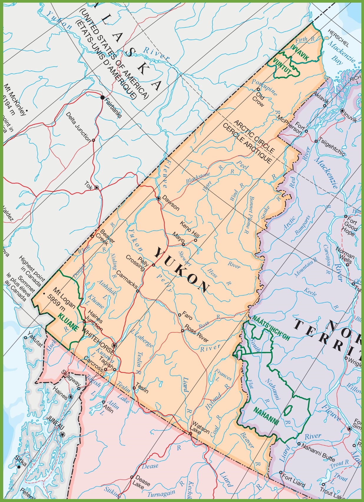
The large detailed map of Yukon with cities and towns is a comprehensive visual guide to this rugged and scenic Canadian territory. With dimensions of 1236 by 1702 pixels, the map provides a clear view of Yukon’s extensive network of communities, roads, and natural landmarks.
The map likely includes the capital city of Whitehorse, which is a central hub for travel and commerce in the territory. It also shows other significant towns such as Dawson City, known for its historical significance during the Klondike Gold Rush, and Watson Lake, famous for its Sign Post Forest. The map details the territory’s vast wilderness areas, highlighting the locations of national parks and recreation sites, which are essential for outdoor enthusiasts looking to explore Yukon’s pristine landscapes.
This map is an invaluable resource for anyone traveling through Yukon, offering detailed information on the territory’s infrastructure and points of interest.
Please visit this page for other map resources or Google Maps.
What are Such Maps Used for?
Maps are essential tools for travelers and researchers, helping them understand the geography and features of a particular area. Our detailed map of Yukon with cities and towns is handy for those interested in planning a road trip, visiting national parks, or exploring the territory’s natural resources. With the map’s comprehensive view of Yukon’s roads, railways, and national parks, visitors can plan their trip efficiently and better understand this vast and beautiful territory.
Did You Know about Yukon?
Yukon, a territory that epitomizes the wild, untamed spirit of the North, is a treasure trove of natural wonders and cultural history. It is home to several national parks, each offering a distinct experience of the North’s rugged beauty and ecological diversity.
Kluane National Park and Reserve, a gem among these, is a UNESCO World Heritage Site that boasts a vast wilderness of ice fields and mountain ranges, including Mount Logan, Canada’s highest peak. The park’s extensive ice fields are among the world’s most extensive non-polar ice fields, providing a dramatic backdrop for hiking, mountaineering, and flightseeing tours.
In addition to Kluane, Yukon’s Ivvavik National Park offers visitors the chance to witness the Porcupine caribou herd’s annual migration, a breathtaking natural spectacle. Vuntut National Park, in the north of Yukon, protects a portion of the Old Crow Flats, one of North America’s most important wetlands and a key site for waterfowl breeding.
The Tombstone Territorial Park, with the jagged peaks of the Tombstone Mountains, offers a landscape straight out of a fantasy novel. The park’s unique geology, flora, and fauna are accessible via the Dempster Highway, which cuts through the park, providing a scenic route for travelers seeking adventure.
Yukon also has a rich cultural heritage, with the Tr’ondëk Hwëch’in traditional territory encompassing the Klondike Gold Rush’s epicenter, Dawson City. The region’s history is preserved in the SS Klondike National Historic Site in Whitehorse and the Dredge No. 4 near Dawson City, offering a glimpse into the gold rush era’s life and challenges.
For those interested in the night sky, Yukon is one of the best places in the world to view the Northern Lights (Aurora Borealis), with the auroral display frequently visible in the territory’s dark skies.
Yukon’s natural beauty extends to its waterways, with the Yukon River itself being a historic route for First Nations people and, later, during the gold rush. Today, it provides opportunities for canoeing and kayaking, allowing visitors to follow the routes of early explorers and prospectors.
Whether it’s the call of the wild, the allure of history, or the pursuit of solitude, Yukon’s national parks and unique landscapes offer an escape into a land that remains as timeless as it is beautiful.
Conclusion
Whether you’re planning a road trip through Yukon or simply interested in learning more about Canada’s northwestern territory, our detailed map is an excellent resource. With its comprehensive view of Yukon’s cities, towns, rivers, lakes, Trans-Canada highway, major highways, secondary roads, winter roads, railways, and national parks, our map is the perfect tool for exploring and understanding this unique and culturally rich region.