The Yukon is known for its vast wilderness, stunning landscapes, and rich indigenous culture. With its diverse terrain, traveling through the Yukon requires careful planning and understanding of its roads and highways. Our detailed Yukon road map provides a comprehensive view of the territory’s highways, main roads, secondary roads, rivers, lakes, national parks, and provincial parks, making navigating this unique and beautiful region easier.
The Yukon Road Map
This map shows Yukon’s cities, towns, highways, main roads, secondary roads, rivers, lakes, national parks, and provincial parks.
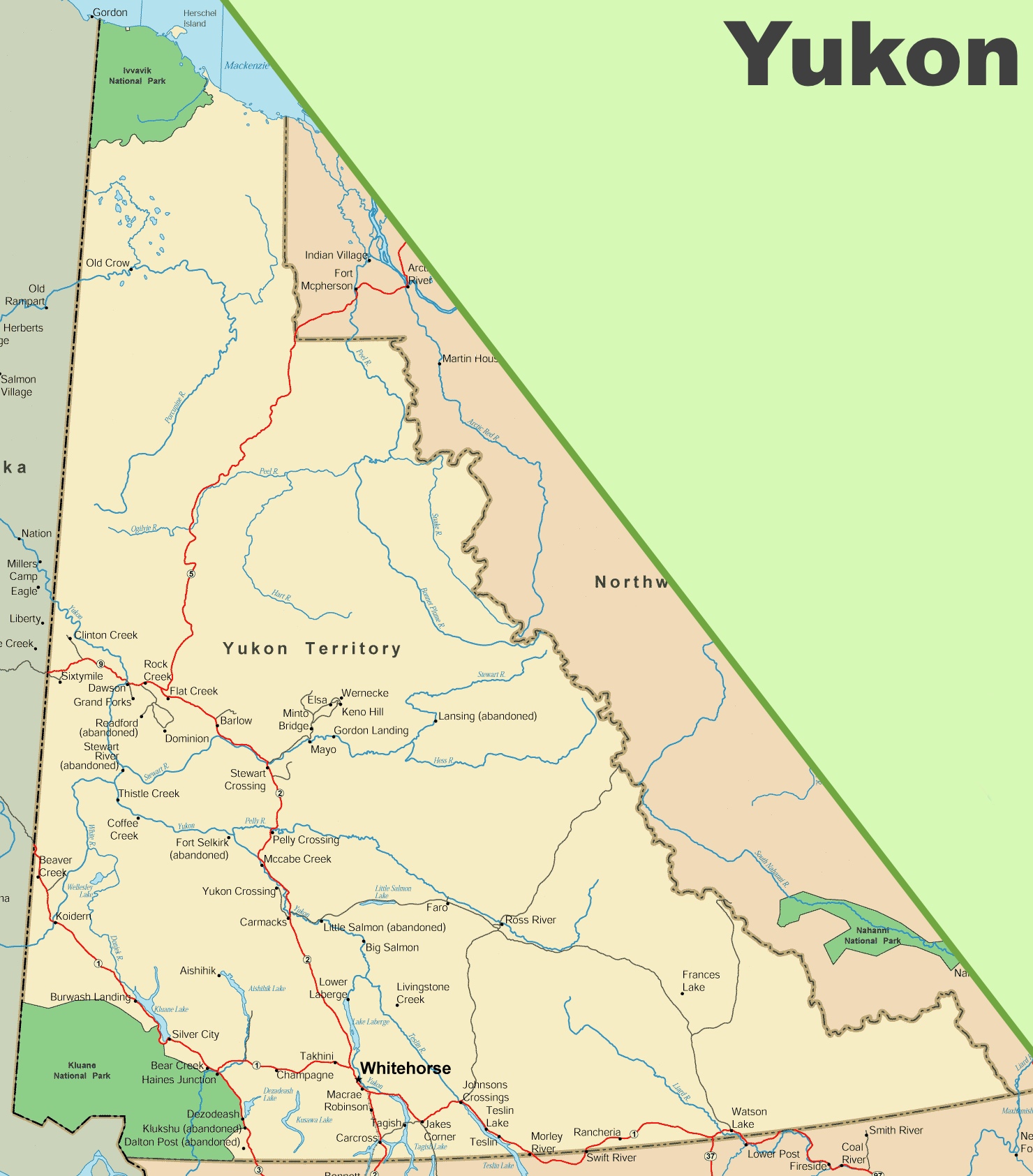
The Yukon Road Map is a comprehensive guide to the highways and byways of this expansive Canadian territory. With dimensions of 1480 by 1685 pixels, the map provides a detailed look at the transportation network that connects the remote communities and stunning landscapes of Yukon.
The map likely includes the Klondike Highway, which connects the capital city of Whitehorse to Dawson City, the heart of the Klondike Gold Rush. It also shows the Alaska Highway, which traverses Yukon from Watson Lake in the southeast to Beaver Creek in the northwest, providing a vital link to Alaska and British Columbia.
Other roads, such as the Robert Campbell Highway, which leads to the historic town of Mayo and the beautiful Frances Lake, are also featured. The map indicates the location of Fort Selkirk, an abandoned community that offers a glimpse into Yukon’s past and highlights the Stewart-Cassiar Highway, a scenic route that offers access to the southern part of the territory.
For adventurers, the map shows the Silver Trail leading to the community of Keno City, a gateway to the backcountry, and the Dempster Highway, which stretches to the Arctic Circle and beyond, offering a rugged journey to the far north.
This map is an invaluable tool for anyone planning a road trip in Yukon, providing essential information on the territory’s road conditions, distances between locations, and points of interest along the way.
Please visit this page for other map resources or Google Maps.
What Are Such Maps Used For?
A road map is essential for any traveler exploring the Yukon’s natural beauty and cultural attractions. Our detailed map is handy for those planning a road trip, whether a scenic drive along the Alaska Highway or a more off-the-beaten-path adventure. With its detailed view of the Yukon’s roads and highways, visitors can plan their trip efficiently and better understand the territory’s diverse landscapes and unique cultural history.
Did You Know about the Yukon?
The Yukon is a vast and sparsely populated territory in northwestern Canada, known for its stunning natural beauty and rich indigenous culture. Here are some interesting facts about roads and transportation in Yukon:
- The Alaska Highway: One of the most iconic roads in Yukon is the Alaska Highway, which spans 1,387 kilometers through the territory. Built during World War II to connect the United States with Alaska, the highway remains famous for travelers seeking stunning scenery and adventurous driving.
- Winter Roads: During the winter months, Yukon’s remote communities are connected through a network of winter roads. These roads are built on frozen lakes and rivers and provide critical access to supplies and services for residents living in remote areas.
- The Dempster Highway: The Dempster Highway is a gravel road crossing the Arctic Circle from Dawson City to Yukon to Inuvik in the Northwest Territories. The highway is an important transportation route for residents in the northern parts of Yukon and the Northwest Territories.
- Air Travel: With its vast size and remote communities, air travel is an essential mode of transportation in Yukon. Whitehorse International Airport is the territory’s main airport, providing regular flights to and from major Canadian cities such as Vancouver, Calgary, and Edmonton.
- Ferries: Yukon is also home to several ferries that provide transportation across rivers and lakes, particularly in the southern part of the territory. The George Black Ferry, for example, provides transportation across the Yukon River in Dawson City, while the MV Keno provides transportation across the Yukon River in Carmacks.
Overall, roads and transportation in the Yukon are critical for connecting its remote communities and providing access to the territory’s stunning natural beauty and cultural attractions. Whether driving along the Alaska Highway or flying into one of Yukon’s many airports, visitors to the territory are sure to be awe-struck by its vast landscapes and unique cultural heritage.
Conclusion
Whether you’re planning a road trip through the Yukon or simply interested in learning more about this unique and culturally rich region, our detailed road map is an excellent resource. With its comprehensive view of Yukon’s cities, towns, highways, main roads, secondary roads, rivers, lakes, national parks, and provincial parks, our map is perfect for navigating your way through this beautiful and rugged territory.