Saskatchewan, the heart of Western Canada, has a diverse landscape of rolling prairies, rugged Canadian Shield, and abundant natural beauty. If you’re planning a trip to Saskatchewan, having a detailed road map is essential to exploring the province. In this blog post, we’ll introduce you to the Saskatchewan highway map available on canadamaps.com, which shows the province’s cities, towns, highways, main roads, and secondary roads.
Saskatchewan Highway Map
This map shows Saskatchewan’s cities, towns, highways, main roads, and secondary roads.
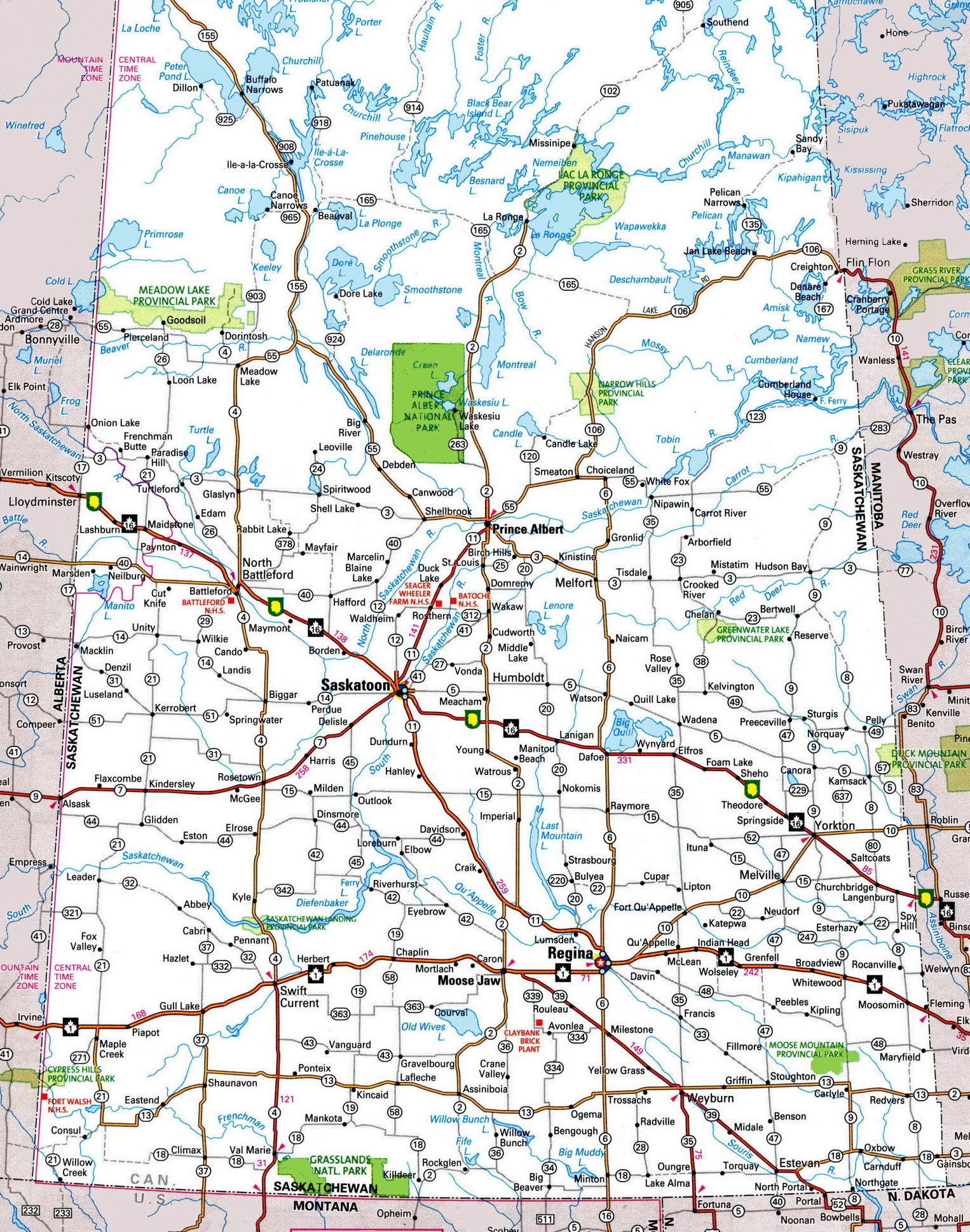
The Saskatchewan highway map is a detailed representation of the province’s highway system, shown at a resolution of 1526×1938 pixels. It includes the main highways and thoroughfares that facilitate travel throughout Saskatchewan. The map is essential for anyone needing to navigate the province’s highways, whether for long-distance travel, commuting, or exploring the diverse regions of Saskatchewan.
Please visit this page for other map resources or Google Maps.
What are Saskatchewan highway maps used for?
Highway maps are essential for anyone traveling by car, whether commuting to work, driving across the country, or exploring a new province. A highway map is a detailed guide that shows the location of highways, main roads, and secondary roads, making it easy to navigate from point A to point B. Saskatchewan highway maps are handy because they show the location of cities and towns along with highways and secondary roads. This makes planning your route easier and choosing the best roads based on your preferences.
Did you know about Saskatchewan?
- Saskatchewan is the only province in Canada without natural borders.
- The province is home to the RCMP Academy, which trains all Royal Canadian Mounted Police officers.
- Regina, the provincial capital, is home to the Royal Saskatchewan Museum, the largest museum in the province.
- Saskatchewan is home to the world’s most enormous curling rock, located in the town of Arborg, and weighs 635 kilograms / 1,400 pounds.
Explore Saskatchewan with the Saskatchewan Highway Map
The Saskatchewan highway map available on canadamaps.com is the ultimate tool for exploring the province. This map shows the location of highways, main roads, secondary roads, and cities and towns in the province. Here are some of the features of this map:
Cities and Towns: The Saskatchewan highway map shows the location of all major cities and towns, including Saskatoon, Regina, Prince Albert, and Moose Jaw. This makes it easy to plan your route and find accommodations and restaurants along the way.
Highways: The highway map shows the location of all major highways in Saskatchewan, including the Trans-Canada Highway and the Yellowhead Highway. This makes it easy to plan your route and navigate through the province.
Main Roads and Secondary Roads: The Saskatchewan highway map shows all primary and secondary roads beside the highways. This is especially important when traveling to smaller towns or rural areas.
Conclusion
Whether planning a road trip, exploring the province, or just needing a detailed guide to navigate through Saskatchewan, the Saskatchewan highway map available on canadamaps.com is the perfect tool for your next adventure. With detailed information on cities, towns, highways, main roads, and secondary roads, this map will guide you to the best spots in the province.