Manitoba is a beautiful Canadian province perfect for road trips and outdoor adventures. If you’re planning a trip to Manitoba, our comprehensive road map is the perfect tool to help you plan your route and discover all the natural and cultural wonders this province offers. In this blog post, we’ll explore what our Manitoba road map shows, what such maps are used for, and some interesting facts about Manitoba.
Manitoba Road Map
This map shows cities, towns, highways, main roads, secondary roads, rivers, lakes, national parks, and provincial parks in Manitoba.
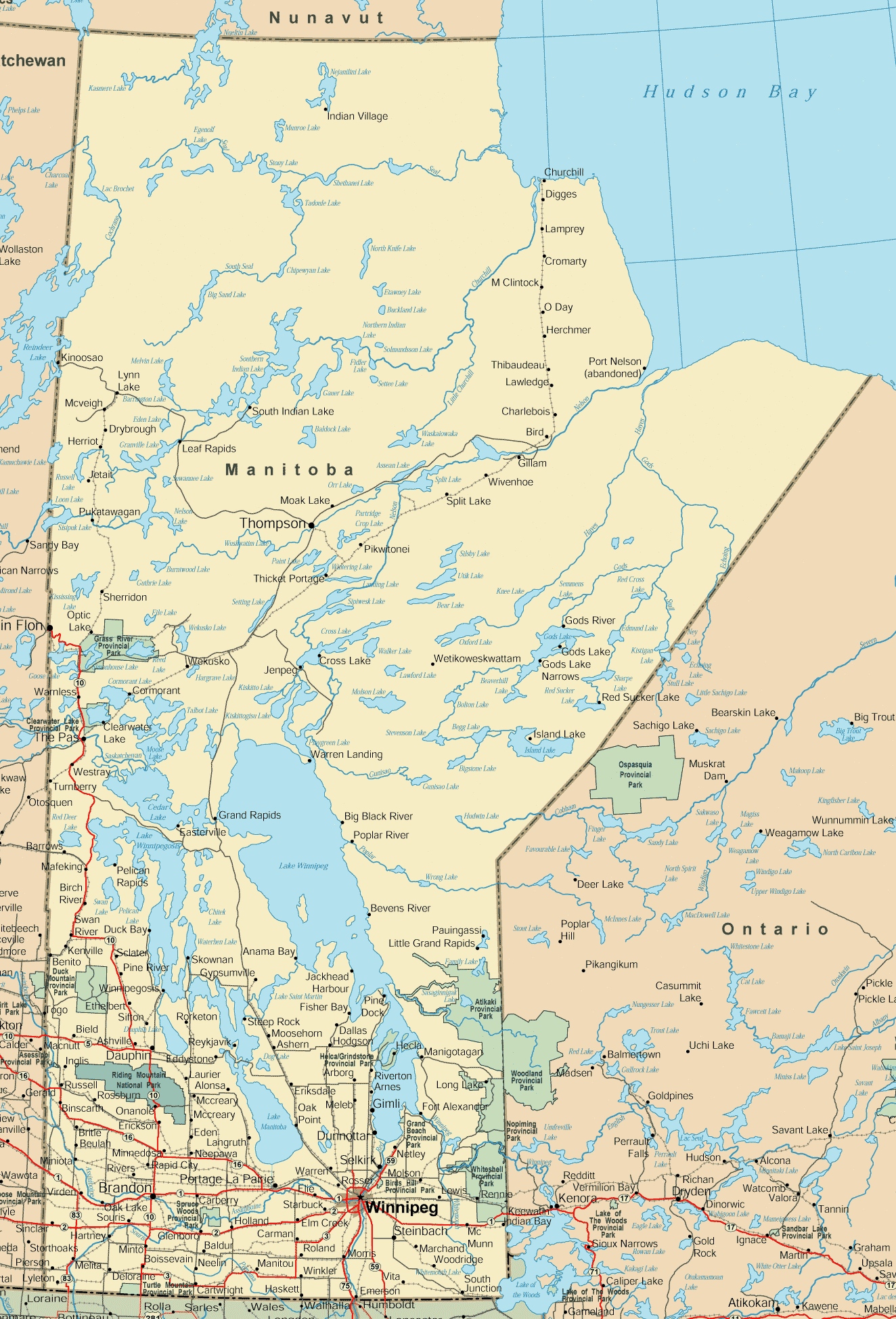
The Manitoba road map is a detailed visual representation of the province’s road network, with a resolution of 1324×1948 pixels. It includes a layout of major highways, secondary roads, and notable geographical features such as lakes and rivers. The map also highlights various points of interest, provincial parks, and remote areas, making it a valuable resource for planning road trips and exploring the diverse landscapes of Manitoba, from the urban centers to the northern wilderness.
Please visit this page for other map resources or Google Maps.
What does this Manitoba map show?
Our Manitoba road map is designed to be comprehensive, showing all major highways, main roads, secondary roads, and essential features of the province, including rivers, lakes, national parks, and provincial parks. The map is easy to read and includes information on the distances between cities and towns, making it easy to plan your route and navigate the province.
What are such maps used for?
Road maps like ours are essential for anyone planning a road trip to Manitoba. Our map can help you plan your route, identify the highways and roads you must take, and better understand the area’s geography. Whether you’re planning a long road trip or a short weekend getaway, our map is the perfect tool to help you explore the beauty of Manitoba.
Did you know about Manitoba?
- Manitoba is located in the heart of Canada and is known for its beautiful lakes, rivers, forests, and vibrant cities and towns.
- The province is home to several major highways, including the Trans-Canada Highway, which runs east to west, and Highway 6, which connects the province to northern Manitoba and the town of Churchill on the shores of Hudson Bay.
- Manitoba has several national and provincial parks, including Riding Mountain National Park, Whiteshell Provincial Park, and Nopiming Provincial Park.
- The province has a rich history and is home to several historic sites and museums, including the Forks National Historic Site in Winnipeg, which marks the meeting point of the Red and Assiniboine Rivers, and the Canadian Museum for Human Rights, also located in Winnipeg.
Conclusion
In conclusion, our Manitoba road map is an essential resource for anyone planning a road trip to explore the beauty of this stunning Canadian province. With its comprehensive coverage of all major highways, main roads, secondary roads, rivers, lakes, national parks, and provincial parks, our map can help you plan your route and discover Manitoba’s unique natural and cultural wonders. Whether you’re a nature lover, a history buff, or an outdoor enthusiast, our map is the perfect tool to help you navigate through Manitoba and explore everything this beautiful province has to offer.