Nunavut is Canada’s northernmost and largest territory, spanning over 2 million square kilometers. The territory is divided into three regions: Kitikmeot, Kivalliq, and Qikiqtaaluk. Our detailed map of Nunavut showcases these three regions, making it easy to explore and understand the unique characteristics of each area.
Nunavut Region Map
This map shows the regions of Nunavut.
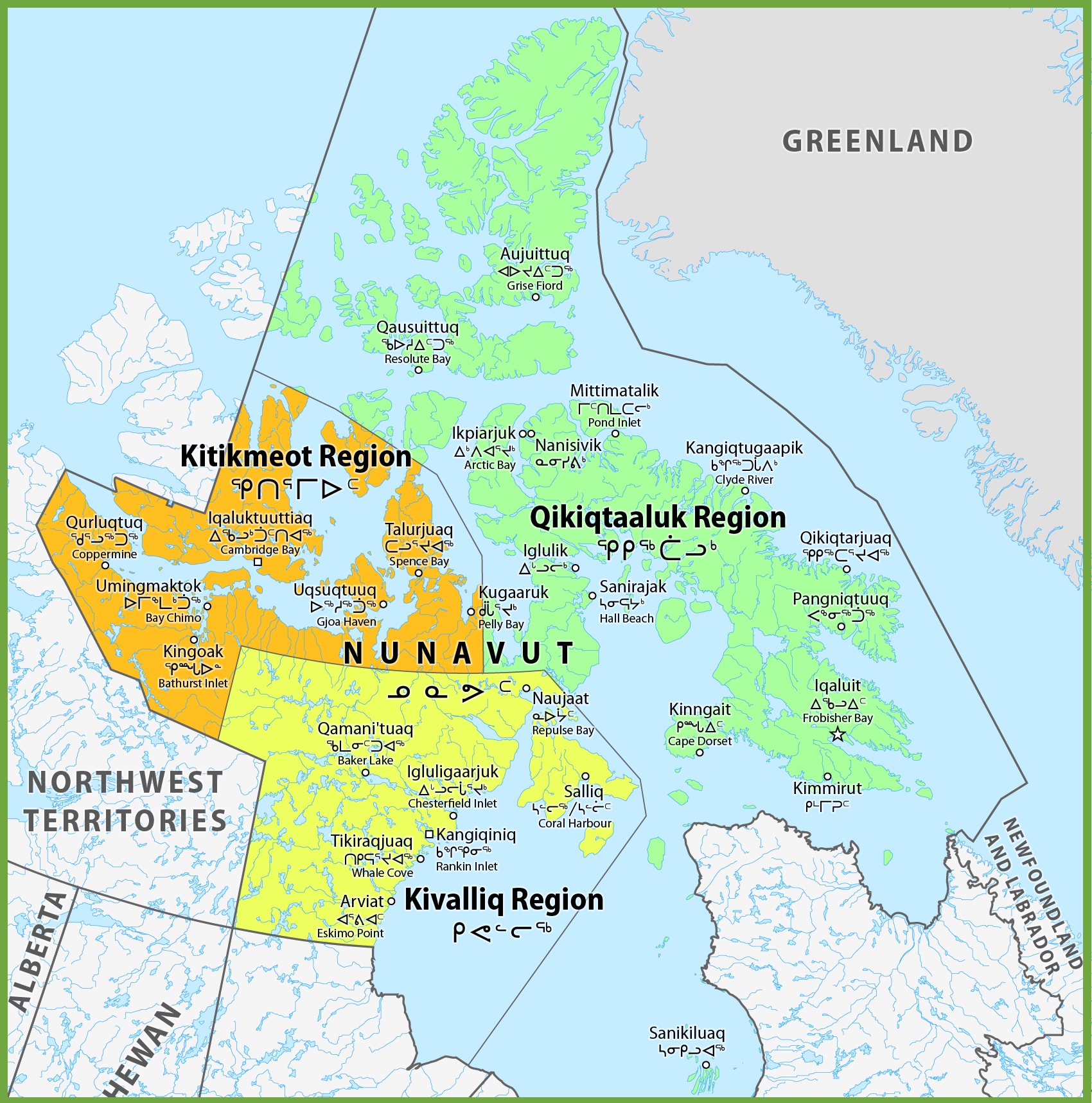
The Nunavut region map, with dimensions of 1700×1717 pixels, provides a detailed view of the territory’s division into three regions: Qikiqtaaluk, Kivalliq, and Kitikmeot. Each region is distinct in its geographical features and cultural heritage.
The map likely outlines key communities within each region, such as Rankin Inlet in the Kivalliq Region, known for its central location and as a hub for transportation and commerce. The Qikiqtaaluk Region, also known as the Baffin Region, includes communities like Pond Inlet (Kangiqtugaapik) and Clyde River (Qikiqtarjuaq), which are gateways to the stunning landscapes of Baffin Island and the nearby fjords, glaciers, and ice caps.
The Kitikmeot Region, the westernmost part of Nunavut, includes Cambridge Bay (Iqaluktuuttiaq), which is a center for traditional Inuit culture and a starting point for Arctic expeditions. The map also shows the proximity of these regions to neighboring areas, such as Greenland, to the east.
This map is an essential tool for understanding the vastness and diversity of Nunavut, providing context for the territory’s geography and the distribution of its population.
Please visit this page for other map resources or Google Maps.
The Kitikmeot Region
The Kitikmeot region is in western Nunavut, bordering the Northwest Territories to the west and the Arctic Ocean to the north. The region has several communities, including Cambridge Bay, Kugluktuk, and Taloyoak. The Kitikmeot region is known for its rugged and barren landscapes, rolling hills, rocky outcrops, and Arctic tundra. The region also has several wildlife species, including caribou, muskoxen, and Arctic foxes. Additionally, the Kitikmeot region is home to several historic sites, including the ruins of a whaling station at Herschel Island.
The Kivalliq Region
The Kivalliq region is in central Nunavut, bordered by Hudson Bay to the west and Hudson Strait to the east. The region has several communities, including Arviat, Baker Lake, and Rankin Inlet. The Kivalliq region is known for its rich wildlife, including caribou, polar bears, and Arctic char. The region is also home to several unique geological formations, such as the Hoodoos, tall, thin spires of rock that have been eroded over time. Additionally, the Kivalliq region is home to several historic sites, including the Thule archaeological site, which dates back to 1000 CE.
The Qikiqtaaluk Region
The Qikiqtaaluk region is located in eastern Nunavut, bordering the Arctic Ocean to the north and Baffin Bay to the south. The region is home to several communities, including Iqaluit, the capital of Nunavut. The Qikiqtaaluk region is known for its stunning landscapes: towering mountains, deep fjords, and vast expanses of the Arctic tundra. The region also has several unique wildlife species, including narwhals, beluga whales, and polar bears. Additionally, the Qikiqtaaluk region is home to several historic sites, including the remains of Thule houses and campsites.
In conclusion, Nunavut’s three regions offer a unique and diverse experience for visitors and residents alike. Whether you’re interested in exploring rugged landscapes, learning about indigenous cultures, or encountering Arctic wildlife, Nunavut’s Kitikmeot, Kivalliq, and Qikiqtaaluk regions have something for everyone.
What are Such Maps Used for?
Maps are essential tools for travelers and researchers, helping them understand the geography and features of a particular area. Our detailed map of Nunavut’s regions is handy for those interested in the territory’s natural resources, indigenous communities, and cultural heritage. With the map’s comprehensive view of Nunavut’s regions, visitors can plan their trip efficiently and better understand this vast and beautiful territory.
Did You Know about Nunavut?
Nunavut is home to several indigenous communities, including the Inuit, who have lived in the region for thousands of years. The territory is also rich in natural resources, including minerals, oil, and gas. However, Nunavut’s harsh climate and remote location make resource extraction challenging. Additionally, Nunavut is home to several unique geological formations, such as the Hoodoos in the Kivalliq region.
Conclusion
Whether you’re planning a trip to Nunavut or simply interested in learning more about Canada’s northernmost territory, our detailed map is an excellent resource. With its comprehensive view of Nunavut’s regions, our map is the perfect tool for exploring and understanding this unique and culturally rich region.