Nova Scotia is a stunning province located on the eastern coast of Canada. Known for its rugged coastline, sandy beaches, and charming towns, Nova Scotia is a popular destination for tourists worldwide. Our detailed tourist map is the perfect resource for planning a trip to Nova Scotia or learning more about this beautiful province. In this blog post, we’ll explore what this map shows, what such maps are used for, and some interesting facts about Nova Scotia.
Large Detailed Tourist Map of Nova Scotia
This map shows cities, towns, resorts, beaches, rivers, lakes, highways, major roads, secondary roads, ferries, travel regions, points of interest, and national parks in Nova Scotia.
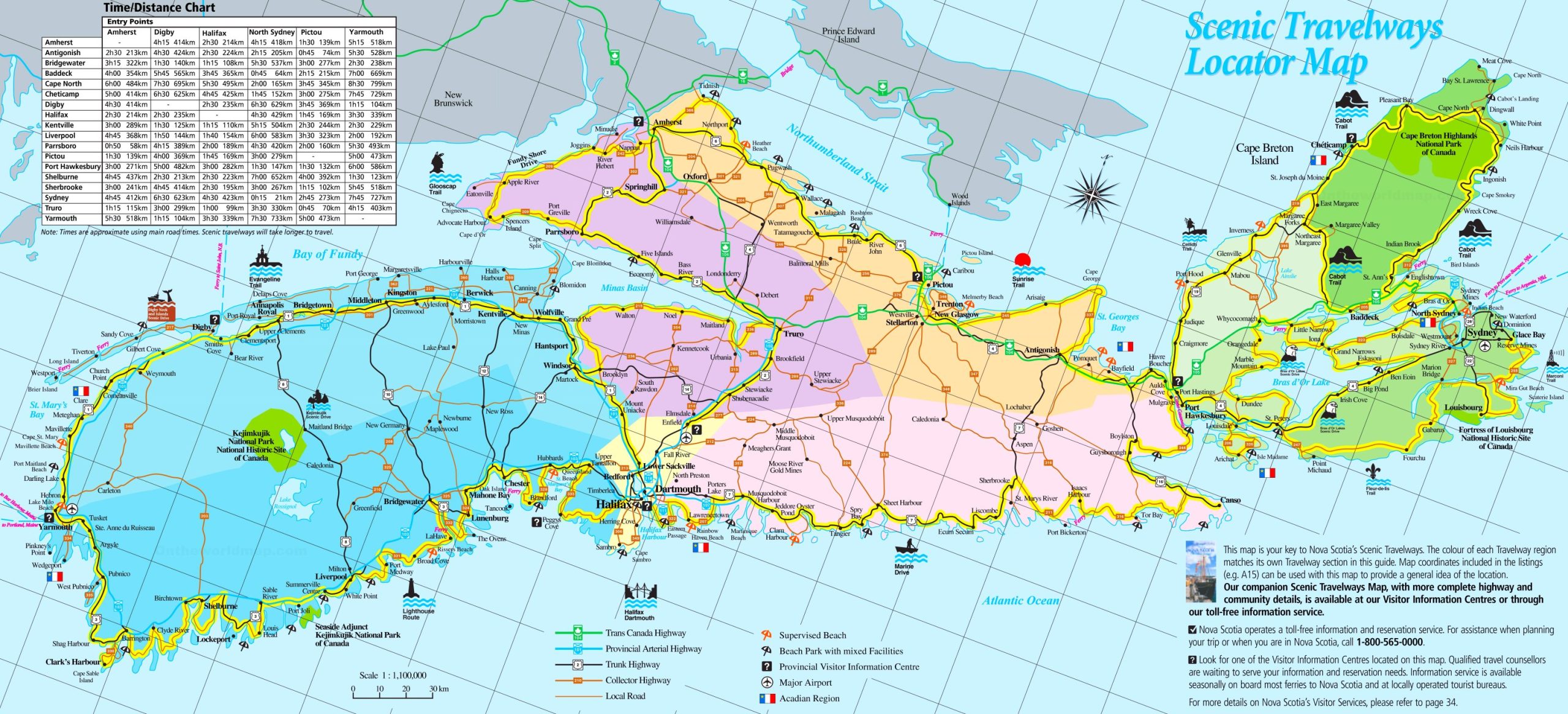
The tourist map of Nova Scotia is a detailed visual guide for travelers, rendered at a high resolution of 2560×1167 pixels. It features a comprehensive layout of the province’s scenic travelways, highlighting key destinations, visitor information centers, major airports, and the Acadian region. The map is color-coded to match the Travelway regions with their sections in the guide and includes map coordinates for easy location referencing. This map is a valuable resource for anyone planning to explore the scenic beauty and cultural heritage of Nova Scotia.
Please visit this page for other map resources or Google Maps.
What does this Nova Scotia map show?
Our map of Nova Scotia is designed to be comprehensive, showing all major cities, towns, resorts, beaches, rivers, lakes, highways, major roads, secondary roads, ferries, travel regions, points of interest, and national parks in the province. Whether you’re planning a road trip or want to explore the area, our map can help you plan your itinerary and better understand Nova Scotia’s geography.
What are such maps used for?
Maps like ours are incredibly useful for a variety of purposes. If you’re planning a road trip through Nova Scotia, our map can help you plan your route and identify interesting stops. If you’re interested in hiking, camping, or other outdoor activities, our map can help you locate the best spots to enjoy these activities. And if you’re simply interested in learning more about Nova Scotia, our map can help you better understand the province’s geography and topography.
Did you know about Nova Scotia?
- Nova Scotia is one of Canada’s Maritime Provinces on the east coast.
- The province is known for its stunning coastline, which stretches over 13,000 kilometers and includes over 3,800 islands.
- Halifax, the capital of Nova Scotia, is home to the world’s second-largest natural harbor and is a popular tourist destination.
- Nova Scotia is known for its delicious seafood, including lobster, scallops, and salmon.
Conclusion
In conclusion, our detailed tourist map of Nova Scotia is an essential resource for anyone interested in exploring this beautiful province. Whether planning a trip or wanting to learn more about Nova Scotia, our map can help you identify the best spots to visit and better understand the area’s geography and topography. With its comprehensive coverage of cities, towns, resorts, beaches, rivers, lakes, highways, major roads, secondary roads, ferries, travel regions, points of interest, and national parks, our map is the perfect tool for anyone interested in discovering the beauty of Nova Scotia.