A detailed area map is essential if you’re planning a road trip through Nova Scotia. Our road map of Nova Scotia is designed to help you navigate your way through the province, showing all major cities, towns, highways, main roads, secondary roads, national parks, and provincial parks in the area. In this blog post, we’ll explore what this map shows, what such maps are used for, and some interesting facts about Nova Scotia.
Nova Scotia Road Map
This map shows cities, towns, highways, main roads, secondary roads, national parks, and provincial parks in Nova Scotia.
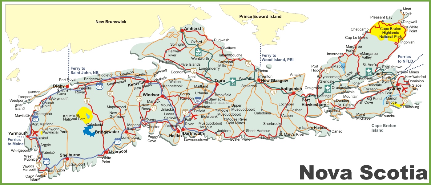
The Nova Scotia road map visually represents the province’s road infrastructure, displayed at a resolution of 1400×600 pixels. It outlines the major highways and roads that traverse the scenic landscapes of Nova Scotia, connecting key cities, towns, and tourist destinations. The map also indicates ferry routes, including those to Newfoundland and Prince Edward Island, and highlights natural landmarks like Cape Breton Island and Pleasant Bay. It’s a useful guide for travelers planning to navigate the roads of Nova Scotia, whether for leisure or business.
Please visit this page for other map resources or Google Maps.
What does this Nova Scotia map show?
Our road map of Nova Scotia is designed to be comprehensive, showing all major cities, towns, highways, main roads, and secondary roads in the province. We also highlight the location of national and provincial parks, popular destinations for tourists and locals alike. Whether you’re planning a long road trip or want to explore the area by car, our map can help you plan your route and better understand Nova Scotia’s geography.
What are such maps used for?
Road maps like ours are handy for anyone planning a road trip or looking to navigate their way through a new area. Our map can help you plan your route, identify exciting stops, and better understand the area’s geography and topography. Whether you’re a tourist visiting Nova Scotia for the first time or a resident exploring your home province, our road map is an essential tool for any driver.
Did you know about Nova Scotia?
- Nova Scotia is home to several historic lighthouses, including Peggy’s Point Lighthouse, one of Canada’s most photographed lighthouses.
- The province is known for its delicious seafood, including lobster, scallops, and oysters.
- Nova Scotia is the second-smallest province in Canada, but it’s also the second-most densely populated.
- The Cabot Trail, a scenic drive loop around Cape Breton Island’s northern tip, is one of Canada’s most famous road trips.
Conclusion
In conclusion, our road map of Nova Scotia is an essential resource for anyone planning a road trip or looking to navigate the province. With its comprehensive coverage of cities, towns, highways, main roads, secondary roads, national parks, and provincial parks, our map can help you plan your route, identify exciting stops, and better understand the geography and topography of the area. Whether you’re a tourist or a resident, our road map is the perfect tool for exploring the beauty of Nova Scotia.