Canadamaps.com offers a comprehensive and up-to-date map of Canada, providing a detailed view of the country’s governmental boundaries, transportation infrastructure, and natural landscapes. This map is an update to the 1:6 000 000 paper map of Canada published in 2006 and uses a vertical near-side perspective projection to provide a unique three-dimensional view of Canada.
The map includes information, including governmental boundaries of countries, provinces, and territories, provincial and territorial capitals, cities, and towns. It also highlights major transportation routes, including multi-lane highways, highways, roads, ferry routes, and railways.
One of the most valuable features of the map is the inclusion of winter roads, which are critical transportation links in many northern communities during the winter months. These roads are not found on most maps. Still, they are essential for those living in remote communities. Their inclusion on this map demonstrates the commitment of Canadamaps.com to providing the most comprehensive and accurate view of Canada possible.
In addition to transportation infrastructure, the map also includes national parks, highlighting the incredible natural beauty of Canada. This feature is sure to be appreciated by outdoor enthusiasts and nature lovers, as it provides a clear picture of the vast expanses of wilderness that can be found throughout the country.
Reference Map of Canada
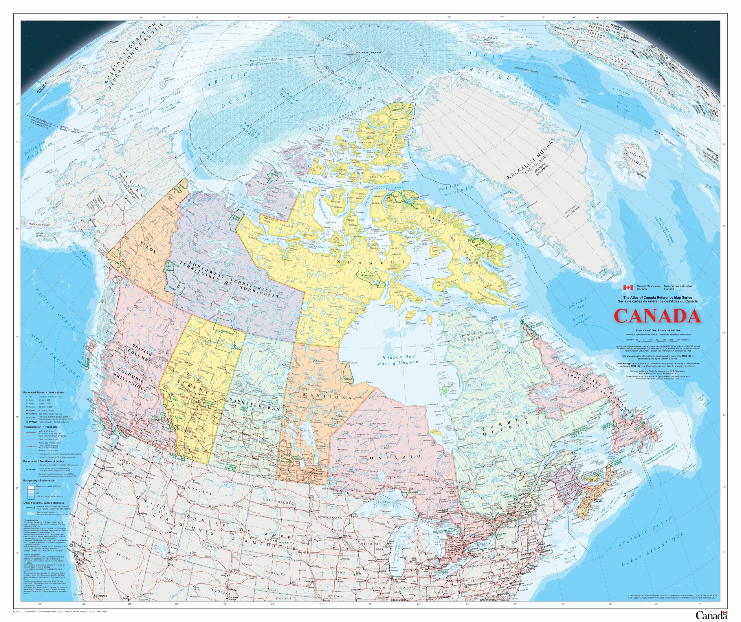
The image is a high-resolution file that presents a detailed reference map of Canada. The map’s dimensions are 2560 pixels in width and 2151 pixels in height, offering a clear and comprehensive view of Canada’s geography. This reference map likely includes important geographical features such as provinces, territories, major cities, road networks, bodies of water, and possibly topographical elements. It’s designed to serve as an informative tool for educational purposes, travel planning, or as a visual guide for those interested in Canada’s geographical layout.
Downloadable Reference Map of Canada
It is an update to the 1:6 000 000 paper map of Canada published in 2006. The map uses a vertical near-side perspective projection, which provides a unique three-dimensional view of Canada. Most data are current to the period 2010 to 2013.
Not only is the map provided by CanadaMaps.com a valuable resource for anyone looking to explore Canada, but it is also incredibly accessible. The map is available to download and print, making it easy to take with you on the go. This is especially useful for those planning road trips or other travel within Canada, as it provides a detailed view of the country’s transportation infrastructure and highlights the locations of important landmarks and attractions.
- Click here to download this map of Canada in a large, printable file in the format JPG.
- Click here to download this map of Canada in a large, printable file in the format PDF.
One of the most notable features of this map is its coverage of all 13 provinces and territories in Canada. From the Atlantic provinces of Newfoundland and Labrador, Nova Scotia, Prince Edward Island, and New Brunswick to the central provinces of Quebec and Ontario and the western provinces of Manitoba, Saskatchewan, Alberta, and British Columbia, the map provides a comprehensive view of the entire country. It also includes the three territories of The Yukon, Northwest Territories, and Nunavut, which are often overlooked on other maps.
By including all provinces and territories, the map provides a complete view of Canada’s vast and diverse landscape, from the rugged coastlines of Newfoundland to the towering peaks of the Rocky Mountains in Alberta and British Columbia. This comprehensive view of the country is essential for anyone exploring Canada. The detailed information the map provides will surely be appreciated by travelers, researchers, and anyone interested in geography or Canadian history.
In conclusion, CanadaMaps.com offers an excellent resource for those exploring Canada, with a detailed and comprehensive map highlighting all provinces and territories. With the ability to download and print the map, it is an accessible and valuable tool for anyone planning to travel within Canada or seeking a deeper understanding of the country’s geography and infrastructure.
Did you know about Canada?
- Did you know that Canada is the second-largest country in the world, covering over 9.9 million square kilometers? The Reference Map of Canada is a valuable resource for exploring this vast and diverse country.
- The Reference Map of Canada includes important information about Canada’s three territories: Yukon, Northwest Territories, and Nunavut. Did you know that Nunavut is Canada’s largest and newest territory, established in 1999?
- Canada has the world’s longest coastline, stretching over 202,080 kilometers. The Reference Map of Canada can help you explore this vast shoreline and discover the country’s many islands, peninsulas, and bays.
- The Reference Map of Canada includes information about Canada’s national parks and other protected areas, which cover over 1.3 million square kilometers. Did you know Canada, after Russia and Australia, has the world’s third-largest protected area system?
- Canada is home to many unique and diverse ecosystems, from the temperate rainforests of the Pacific Northwest to the tundra of the Arctic. The Reference Map of Canada can help you explore these different regions and learn more about Canada’s rich biodiversity.
- Did you know that Canada has a population of over 38 million people, with the majority living in urban areas? The Reference Map of Canada includes information about Canada’s major cities, urban centers, and rural and remote communities.
- The Reference Map of Canada includes essential information about Canada’s transportation infrastructure, including major highways, railways, airports, and seaports. Canada has the world’s longest highway, the Trans-Canada Highway, which stretches over 7,800 kilometers from Victoria, British Columbia, to St. John’s, Newfoundland.
- Canada is a multicultural country, with people from many different backgrounds and ethnicities. The Reference Map of Canada includes information about Canada’s indigenous peoples, who have lived in Canada for thousands of years and continue to play an important role in the country’s cultural and social fabric.
- Canada is a land of natural resources, including forests, minerals, and energy. The Reference Map of Canada includes information about Canada’s resource extraction industries, including mining, forestry, and oil and gas.
- Canada is a member of many international organizations, including the United Nations, NATO, and the Commonwealth. The Reference Map of Canada can help you understand Canada’s place in the world and its role in global affairs.
Visit this link for other Canada-related map resources.