Canada Reference Map

Home » Canada Reference Map

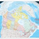
Large, printable, detailed reference map of Northern Canada with cities and towns

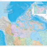
The Northern Canada / Nord du Canada map from CanadaMaps.com is a highly detailed and informative map of the northern areas of the provinces, as well as the three territories and adjacent areas of Russia, Alaska, and Greenland.

Home » Canada Reference Map

Large, printable, detailed reference map of Canada with cities and towns

It is an update to the 1:6 000 000 paper map of Canada published in 2006. The map uses a vertical near-side perspective projection, which provides a unique three-dimensional view of Canada. Most data are current to the period 2010 to 2013.