Prince Edward Island is a stunning island province located in eastern Canada. Known for its scenic drives, beautiful beaches, and charming towns, it’s a popular destination for road trips. A road map is essential for exploring the island’s many attractions and finding your way around. This article will introduce you to a detailed road map of Prince Edward Island and how to use it to make the most of your trip.
Prince Edward Island Road Map
This map shows cities, towns, highways, major roads, secondary roads, airports, beaches, lighthouses, and scenic views on Prince Edward Island.
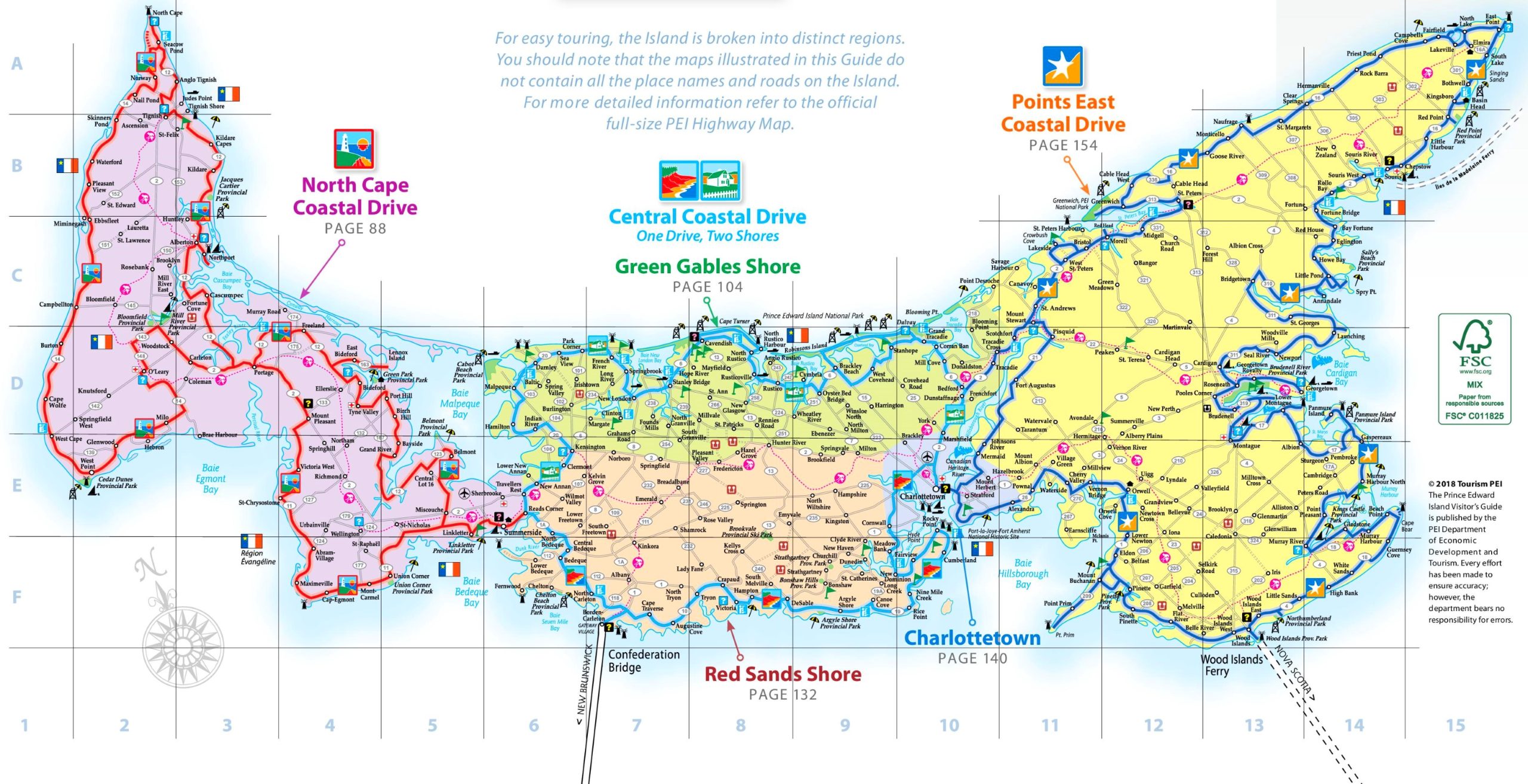
The Prince Edward Island road map is a visual guide to the island’s road system, presented at a resolution of 2560×1314 pixels. It divides the island into distinct regions for easy touring, such as North Cape, Central Coastal Drive, Green Gables Shore, Points East Coastal Drive, and Red Sands Shore. The map provides a general overview and suggests referring to the official full-size PEI Highway Map for more detailed information. It’s a useful resource for visitors planning their travel across the island, offering a snapshot of the main routes and regions.
Please visit this page for other map resources or Google Maps.
What to expect on a road trip to Prince Edward Island
A road trip to Prince Edward Island is a unique experience that offers breathtaking views of the island’s coastline and countryside. The island is small, measuring only 224 kilometers from tip to tip, so it’s easy to explore all corners by car. You’ll find charming towns, lighthouses, and pristine beaches along the way. The road map guides you to discover all the island’s hidden gems.
Key features of the road map
The road map of Prince Edward Island is a detailed map that includes all major highways, secondary roads, and scenic drives. It also highlights important landmarks such as national parks, beaches, lighthouses, and towns. The map includes a legend that makes it easy to understand and navigate. The large and detailed map makes it easy to plan your route and find your way around the island.
Tips for using the road map
When planning your road trip to Prince Edward Island, it’s important to take the time to study the map and plan your route. Identify the major highways and secondary roads that will take you to your desired destinations. Use the legend to identify important landmarks and attractions, and plan you’re itinerary accordingly. Don’t forget to leave room for spontaneous detours and adventures.
Fun facts about Prince Edward Island
- Prince Edward Island is the smallest province in Canada, both in size and population.
- The island is famous for its delicious potatoes, which are exported all over the world.
- Anne of Green Gables, a classic novel by Lucy Maud Montgomery, is set on Prince Edward Island and has become a cultural icon of the island.
- The Confederation Bridge, which connects Prince Edward Island to mainland Canada, is the longest in Canada, measuring 12.9 kilometers.
Conclusion
Prince Edward Island is a beautiful and unique destination for a road trip. A road map is an essential tool for exploring the island and discovering all its hidden treasures. With the detailed map and tips in this article, you’ll be well-prepared to make the most of your trip to Prince Edward Island.