Prince Edward Island, the smallest province in Canada, is a hidden gem waiting to be explored. With its picturesque beaches, charming small towns, and friendly locals, it’s no wonder this island has become a popular destination for travelers worldwide. If you’re planning a trip to Prince Edward Island, our detailed map can help you navigate the island and discover all it has to offer. This blog post will examine our map, interesting facts about Prince Edward Island, and must-see attractions you won’t want to miss.
Large Detailed Map of Prince Edward Island with Cities and Towns
This map shows cities, towns, rivers, lakes, airports, major highways, secondary roads, and national parks on Prince Edward Island.
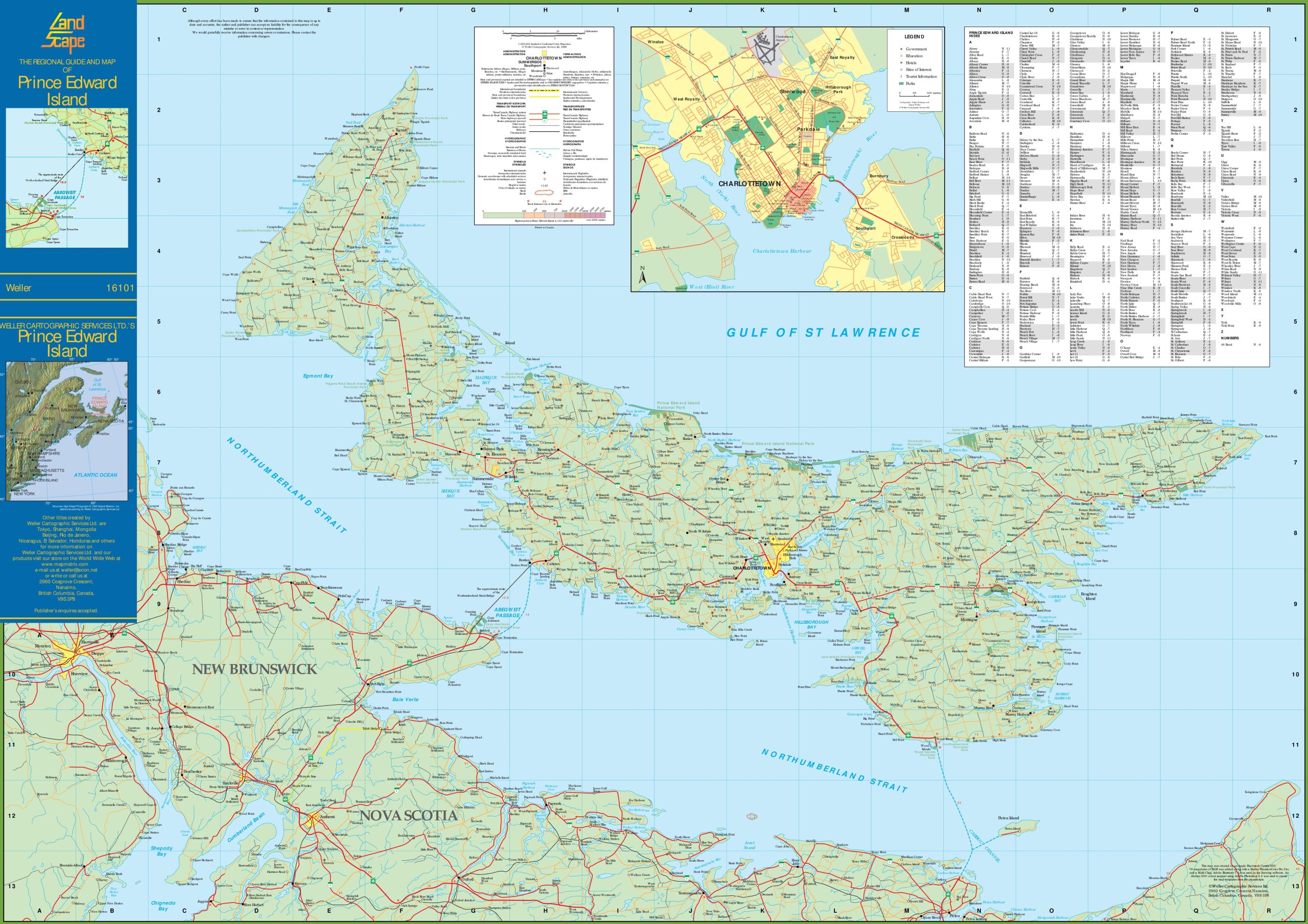
The large detailed map of Prince Edward Island with cities and towns is a comprehensive visual resource, displayed at a resolution of 2560×1809 pixels. It provides an extensive overview of PEI, highlighting its cities, towns, and the intricate network of roads that connect them. The map includes geographical features such as the Gulf of St. Lawrence and various bays, rivers, and inlets that define the island’s topography. This map is an invaluable tool for anyone looking to explore Prince Edward Island, offering detailed insights into the province’s layout and infrastructure.
Please visit this page for other map resources or Google Maps.
What does this Prince Edward Island map show?
Our detailed map of Prince Edward Island shows all significant cities and towns and essential features of the island, including rivers, lakes, airports, major highways, and secondary roads. The map also includes information on national parks and other attractions, making it easy to plan your route and explore all that Prince Edward Island has to offer.
Interesting facts about Prince Edward Island
- Prince Edward Island is the smallest province in Canada, with a total land area of just 5,660 km².
- The island is known for its red sand beaches, which get their color from the high iron content in the soil.
- The island is famous for its seafood, including lobster, mussels, and oysters.
- Prince Edward Island is also the birthplace of Lucy Maud Montgomery, the author of the classic novel Anne of Green Gables.
Must-see attractions on Prince Edward Island
- Green Gables Heritage Place: This historic site inspires the beloved novel Anne of Green Gables and offers visitors a chance to step back in time and experience life in the late 19th century.
- Cavendish Beach: This stunning beach is one of the most popular attractions on Prince Edward Island, with its red sand and clear blue waters.
- Confederation Trail: This 435 km trail is perfect for cycling or hiking, offering stunning views of the island’s countryside and coastline.
- Charlottetown: This charming small town is the capital of Prince Edward Island and is home to many historic sites, museums, and art galleries.
Conclusion
In conclusion, our detailed map of Prince Edward Island is the perfect tool to help you discover all these charming island offers. With its comprehensive coverage of all major cities and towns, as well as important features of the island, our map can help you plan your route and explore everything from picturesque beaches to charming small towns. Whether you’re a first-time visitor or a seasoned traveler, our map is an essential resource for anyone looking to experience the unique beauty and culture of Prince Edward Island.