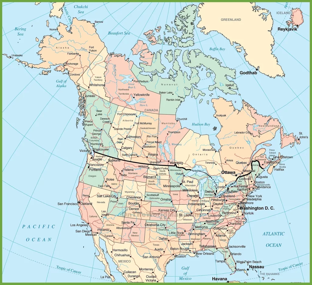
Are you planning a trip to North America and wondering about the government boundaries of the United States and Canada? Look no further than this comprehensive map, which displays the governmental boundaries of countries, states, provinces, provincial capitals, cities, and towns in the USA and Canada.
USA and Canada map
This map shows the governmental boundaries of countries, states, provinces, and provinces’ capitals, cities, and towns in the USA and Canada.

This detailed map provides a comprehensive view of the United States and Canada, highlighting the international boundary and showcasing the expanse of both countries in a single frame. The map, with dimensions of 1024×935 pixels, is designed for clarity and ease of use, making it an ideal reference for educators, students, and anyone interested in the geographical relationship between these neighboring nations.
What are such maps used for?
Maps that show governmental boundaries are essential for a variety of purposes. They are often used in politics and international relations to understand different nations’ territorial divisions, jurisdictions, and subdivisions. Such maps can also be helpful for travelers, as they provide an overview of the different regions and provinces within a country or region. Additionally, they can be used by researchers and academics studying the political and social structures of different regions.
Did you know about Canada?
- Canada is the second-largest country in the world by land area, covering approximately 9.98 million square kilometers.
- The Canadian Shield, which covers about half of Canada’s landmass, is one of the oldest rock formations on Earth, dating back to over 3 billion years ago.
- Canada has the longest coastline of any country globally, stretching over 202,080 kilometers.
- The highest mountain in Canada is Mount Logan, located in the Yukon, which stands 5,959 meters tall.
Here is a list of the thirteen provinces and territories of Canada in alphabetical order:
Alberta, British Columbia, Manitoba, New Brunswick, Newfoundland and Labrador, Northwest Territories, Nova Scotia, Nunavut, Ontario, Prince Edward Island, Quebec, Saskatchewan, and the Yukon.
Each province and territory has its unique culture, history, and natural beauty. For example, Alberta is known for its stunning Rocky Mountains and world-class skiing, while Quebec is famous for its French-speaking population and rich history. British Columbia boasts a rugged coastline, ancient forests, and wildlife such as bears, whales, and bald eagles, while the prairie province of Saskatchewan has vast fields of wheat and stunning sunsets. Each province and territory contributes to Canada’s rich tapestry, making it a diverse and vibrant country.
Did you know about the USA?
- The United States is the third-largest country in the world by land area, covering approximately 9.83 million square kilometers.
- The longest river in the United States is the Missouri River, which is approximately 3,767 kilometers long.
- Alaska, located in the far northwest of the USA, is the largest state by land area and is twice the size of Texas.
- The Grand Canyon, located in Arizona, is one of the most visited tourist attractions in the USA, attracting millions of visitors each year.
Here are the 50 states of the USA listed in alphabetical order:
Alabama, Alaska, Arizona, Arkansas, California, Colorado, Connecticut, Delaware, Florida, Georgia, Hawaii, Idaho, Illinois, Indiana, Iowa, Kansas, Kentucky, Louisiana, Maine, Maryland, Massachusetts, Michigan, Minnesota, Mississippi, Missouri, Montana, Nebraska, Nevada, New Hampshire, New Jersey, New Mexico, New York, North Carolina, North Dakota, Ohio, Oklahoma, Oregon, Pennsylvania, Rhode Island, South Carolina, South Dakota, Tennessee, Texas, Utah, Vermont, Virginia, Washington, West Virginia, Wisconsin, and Wyoming.
Each state has its unique history, culture, geography, and economy. For example, California is known for its film and tech industries, beaches, and national parks, while Texas is famous for its oil production, cowboy culture, and BBQ. Some states have world-famous tourist attractions, such as the Grand Canyon in Arizona, Disney World in Florida, and Niagara Falls in New York. Others have rich agricultural traditions, like Iowa and Kansas, or mining histories, like Colorado and West Virginia. Overall, the United States is a diverse and complex country, and exploring its states and regions can be a lifelong adventure.
Conclusion:
The map of the governmental boundaries of the USA and Canada provides a comprehensive overview of the two countries’ political and territorial divisions. Whether you are planning a trip to North America, conducting research, or simply interested in learning more about the region, this map is an invaluable resource. By displaying the provinces, states, cities, and towns of both countries, this map helps users better understand the different regions of North America and the governmental structures that govern them.
For more Canada-related maps, please visit the category of map resources.