The Northwest Territories is a vast and diverse region of Canada, known for its rugged wilderness, stunning natural beauty, and unique Indigenous culture. With so much to see and do, it can be challenging to plan an itinerary and navigate your way around the region. That’s where a comprehensive travel map can come in handy. In this blog post, we’ll take a closer look at what this particular travel map of the Northwest Territories offers and how it can help you plan your perfect trip.
Northwest Territories Travel Map
This map shows points of interest, tourist attractions, and sightseeing in the Northwest Territories.
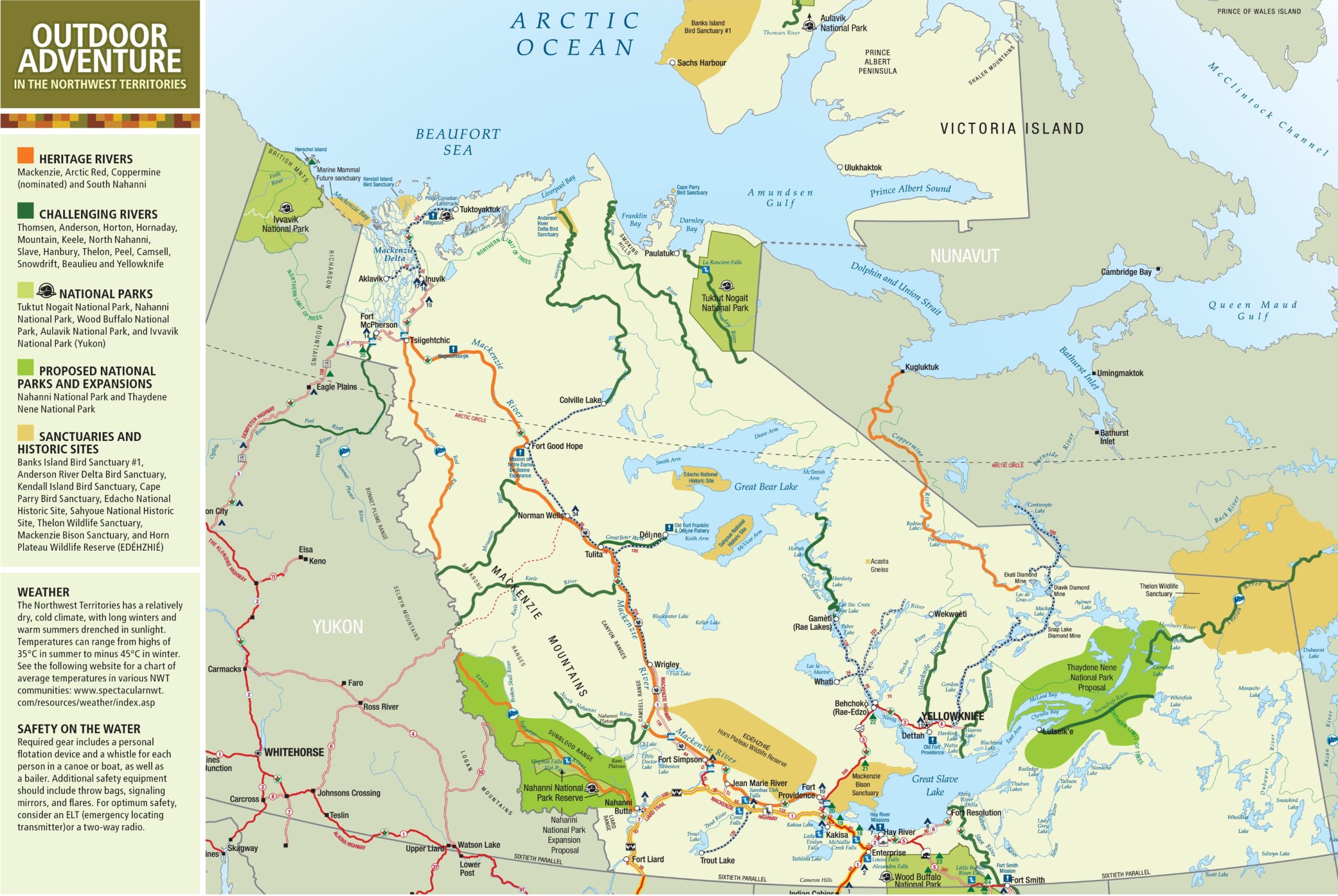
The Northwest Territories travel map, with dimensions of 2560×1715 pixels, is a rich visual guide for outdoor adventure in this northern Canadian region. It highlights the territory’s Heritage Rivers, like the Mackenzie and South Nahanni, challenging rivers, such as the Thomsen and Peel, and national parks, including Tuktut Nogait and Wood Buffalo. The map also notes proposed national parks and expansions, sanctuaries, and historic sites like the Thelon Wildlife Sanctuary and Sahyoue National Historic Site.
The map provides practical information on the region’s weather, which features long, cold winters and warm summers, with temperature ranges from 35°C in summer to -45°C in winter. For safety on the water, it advises on essential gear like personal flotation devices, whistles, throw bags, signaling mirrors, and flares. It also suggests carrying an emergency locating transmitter or a two-way radio for optimum safety.
This map is an essential companion for anyone looking to explore the vast landscapes and natural beauty of the Northwest Territories, providing both inspiration and vital information for a safe and enjoyable adventure.
Please visit this page for other map resources or Google Maps.
What to see and do in the Northwest Territories
If you’re planning a trip to the Northwest Territories, there’s plenty to see and do in Canada’s vast and beautiful region. From majestic national parks to challenging rivers, there’s something for everyone. To help you plan your trip, here’s a map of the Northwest Territories showing some of the top points of interest and tourist attractions.
National Parks: The Northwest Territories has several national parks, each with unique features and attractions. Tuktut Nogait National Park, Nahanni National Park, Wood Buffalo National Park, Aulavik National Park, and Ivvavik National Park (Yukon) are all on the map. Visitors to these parks can enjoy hiking, camping, wildlife viewing, and more.
Heritage Rivers: The Northwest Territories also have four designated Heritage Rivers – the Mackenzie, Arctic Red, Coppermine, and South Nahanni Rivers. These rivers are recognized for their natural and cultural value and provide excellent kayaking, canoeing, and fishing opportunities.
Challenging Rivers: If you’re looking for a more challenging adventure, many rivers in the Northwest Territories are not for the faint of heart. The Thomsen, Anderson, Horton, Hornaday, Mountain, Keele, North Nahanni, Slave, Hanbury, Thelon, Peel, Camsell, Snowdrift, Beaulieu, and Yellowknife rivers are all on the map. These rivers are known for their white water rapids and challenging terrain, and they attract experienced paddlers from around the world.
Proposed National Parks and Expansions: The Nahanni National Park and Thaydene Nene National Park are proposed national parks, and their expansion is currently being considered. These parks offer even more opportunities for visitors to experience the natural beauty of the Northwest Territories.
Sanctuaries and Historic Sites: The Northwest Territories has several bird sanctuaries and historic sites. Banks Island Bird Sanctuary #1, Anderson River Delta Bird Sanctuary, Kendall Island Bird Sanctuary, Cape Parry Bird Sanctuary, Edacho National Historic Site, Sahyoue National Historic Site, Thelon Wildlife Sanctuary, Mackenzie Bison Sanctuary, and Horn Plateau Wildlife Reserve are all on the map. These sites offer visitors a chance to see some of the unique wildlife and learn about the rich history of the Northwest Territories.
This Northwest Territories travel map above highlights some of the region’s top points of interest and tourist attractions. Whether you’re an experienced paddler looking for a challenging adventure or a nature lover looking to explore some of Canada’s most beautiful national parks, the Northwest Territories has something for everyone. Use this map to plan your trip and discover all that the Northwest Territories has to offer.
What else does this travel map offer
This travel map of the Northwest Territories is designed to help visitors explore the region’s top points of interest, tourist attractions, and sightseeing opportunities. It highlights all the major cities and towns, transportation routes, and the various attractions that are not to be missed.
Points of Interest and Tourist Attractions: The primary purpose of this map is to highlight the top points of interest and tourist attractions in the Northwest Territories. Some of the most notable attractions highlighted on the map include:
- The Northern Lights: The Northwest Territories is one of the best places in the world to see the Northern Lights. The map highlights some of the best spots to view this stunning natural phenomenon, including Yellowknife and Inuvik.
- The Mackenzie River is the longest in Canada and is home to several unique and remote communities. The map highlights some of the best spots to explore the river, including Fort Providence and Fort Simpson.
- Indigenous Culture: The Northwest Territories is home to several traditional Indigenous communities, each with unique culture and traditions. The map highlights some of the top cultural attractions in the region, including the Prince of Wales Northern Heritage Centre and the Inuvialuit Cultural Centre.
- National Parks: The Northwest Territories has several national and territorial parks, each with unique landscapes and wildlife. The map highlights some top parks, including Nahanni National Park Reserve and Wood Buffalo National Park.
Did you know about the Northwest Territories?
- The Northwest Territories has several unique and endangered species, including the wood bison, grizzly bear, and Arctic wolf.
- The region is home to several stunning waterfalls, including Virginia Falls in Nahanni National Park Reserve and Alexandra Falls in Twin Falls Gorge Territorial Park.
- The Midnight Sun is visible from the Northwest Territories from mid-May to mid-July, providing visitors with extended daylight hours to explore the region.
Weather
The climate in the Northwest Territories is a unique blend of dry and cold, with long winters and short, warm summers. The territory experiences a wide range of temperatures throughout the year, with summer highs of 35°C and winter lows of minus 45°C. The spectacular NWT website provides a detailed chart of average temperatures in various NWT communities to help travelers prepare for their trip accordingly.
Safety on the Water
Water safety is a crucial consideration for anyone planning to enjoy the many waterways of the Northwest Territories. It is essential to have the required safety gear, including a personal flotation device, a whistle for each person in a canoe or boat, and a bailer. Additional safety equipment such as throw bags, signaling mirrors, and flares can be helpful in an emergency. For optimum safety, consider carrying an emergency locating transmitter (ELT) or a two-way radio to stay in touch with other boaters or emergency services. Being prepared and taking safety precautions can help ensure a safe and enjoyable adventure on the water.
Conclusion
Exploring the top points of interest, tourist attractions, and sightseeing opportunities of the Northwest Territories is an adventure of a lifetime. A comprehensive travel map can help you make the most of your visit. The map on canadamaps.com is an excellent resource for anyone planning a trip to the region. It shows all the major cities and towns, transportation routes, and the various attractions that are not to be missed, making it easy to plan an itinerary and navigate around this stunning part of Canada.