The Northwest Territories is known for its vast and diverse wilderness, home to several national and territorial parks. To make the most of your visit to the region, it’s essential to have a comprehensive map highlighting all the major cities and towns, transportation routes, and the various national and territorial parks. In this blog post, we’ll look at what this particular national parks map offers and how it can help you plan your perfect trip to the Northwest Territories.
Northwest Territories National Parks Map
This map shows cities, towns, rivers, lakes, highways, major highways, secondary roads, winter roads, national parks, and territorial parks in Northwest Territories.
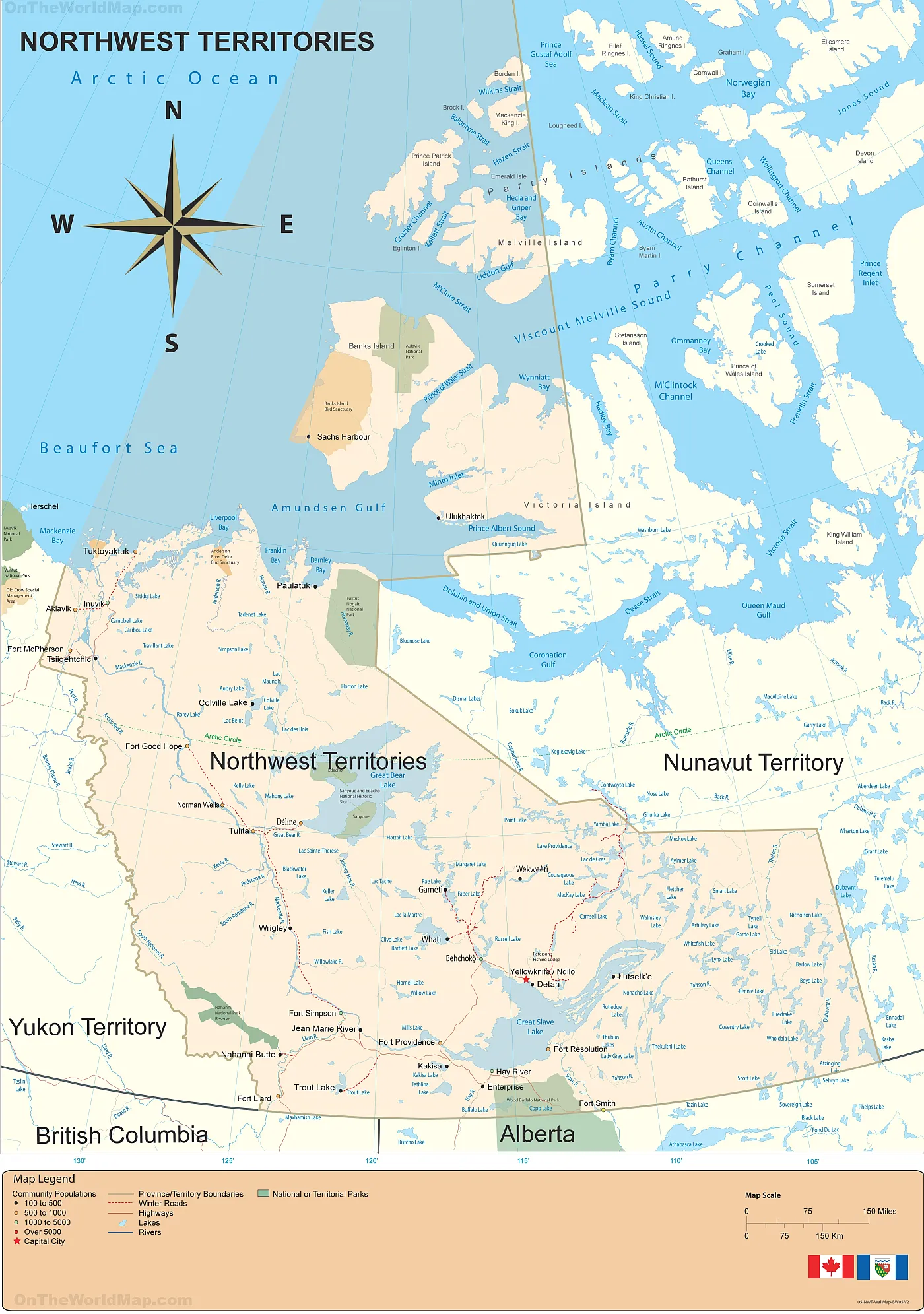
The Northwest Territories National Parks map, with dimensions of 1400×1991 pixels, is a visual guide to the region’s stunning national parks. It showcases the expansive protected areas that are home to diverse ecosystems and wildlife. The map likely includes the renowned Nahanni National Park Reserve, known for its deep river canyons and hot springs, and the Aulavik National Park on Banks Island, famous for its high density of muskoxen. It also probably features Wood Buffalo National Park, a UNESCO World Heritage Site that straddles the Northwest Territories and Alberta. It is known for its free-roaming bison herds and the world’s largest beaver dam. This map invites exploring the untouched wilderness and discovering the natural wonders of Canada’s far North.
Please visit this page for other map resources or Google Maps.
What This National Parks Map Offers
This national parks map of the Northwest Territories is an indispensable resource for any adventurer seeking to immerse themselves in the pristine wilderness of Canada’s North. It goes beyond the usual cartographic details to provide a comprehensive overview of the region’s infrastructure and natural landmarks.
The map meticulously plots the major cities and towns, serving as hubs for explorers venturing into the wild. It traces the veins of the territory—the rivers and lakes that are not just water bodies but corridors of history and culture, vital for the indigenous communities and a paradise for anglers and paddlers.
The highways and roads are clearly marked, distinguishing between major highways that are the lifelines connecting remote communities, secondary roads that lead to less-traveled areas, and winter roads that are seasonal lifelines, passable only during the colder months when the landscape transforms into a frozen highway.
The heart of the map lies in its detailed representation of the national and territorial parks. These areas are sanctuaries of biodiversity, offering a glimpse into the habitats of species like the whooping crane and the wood bison. The map likely includes Nahanni National Park Reserve, with its legendary South Nahanni River and the dramatic Virginia Falls, and Thaidene Nëné, a place of cultural significance to the indigenous peoples and a stunning landscape of tundra, taiga, and the Northern Lights.
For those planning a visit, the map is more than a guide; it’s a preview of the adventures that await. It allows travelers to plot their journey through the vast tracts of untouched nature, plan hikes through ancient rock formations, or canoe trips down heritage rivers. It also serves as a reminder of the remote nature of these regions, emphasizing the importance of preparation and respect for the natural environment.
In essence, this map is not just a tool for navigation but a companion for discovery, inviting visitors to explore, respect, and protect the wild beauty of the Northwest Territories.
National and Territorial Parks
The primary purpose of this map is to highlight the various national and territorial parks in the Northwest Territories. These parks are the perfect destination for those who love the great outdoors and want to experience the region’s stunning natural beauty. Some of the most notable national parks highlighted on the map include:
- Nahanni National Park Reserve: This UNESCO World Heritage Site is known for its stunning canyons, hot springs, and waterfalls. It’s a popular destination for kayaking, rafting, and hiking.
- Wood Buffalo National Park: Canada’s largest national park is home to the world’s largest herd of free-roaming wood bison. It’s also a designated UNESCO World Heritage Site.
- Aulavik National Park: This is the most northerly national park in Canada and is home to several unique wildlife species, including muskoxen and Arctic wolves.
Other parks highlighted on the map include the Thaidene Nene National Park Reserve, Tuktut Nogait National Park, and territorial parks such as the Cameron River Falls Territorial Park and the Sambaa Deh Falls Territorial Park.
Did You Know About the Northwest Territories?
- The Northwest Territories is home to several of the largest lakes in Canada, including Great Slave Lake, Great Bear Lake, and Lake Athabasca.
- The region is also home to several unique and endangered species, including the wood bison, grizzly bear, and Arctic wolf.
- The Northern Lights are visible from the Northwest Territories from September to April, making it a popular destination for stargazing and aurora hunting.
- The region has several traditional Indigenous communities with unique cultures and traditions.
Conclusion
Exploring the national and territorial parks of the Northwest Territories is an adventure of a lifetime, and having a comprehensive national parks map can help you make the most of your visit. The map on canadamaps.com is an excellent resource for anyone planning a trip to the region. It shows all the major cities and towns, transportation routes, and the various national and territorial parks, making planning an itinerary easy and navigating around this stunning part of Canada.