The Northwest Territories is a vast and breathtakingly beautiful region of Canada that’s perfect for outdoor adventures and exploration. However, with so much to see and do, it can be challenging to navigate your way around. That’s where a comprehensive road map comes in handy. Whether planning a road trip, hiking, or camping adventure, having a detailed area map can help you make the most of your time in the Northwest Territories. This blog post will examine what this particular road map offers and how it can help you plan your trip.
Northwest Territories Road Map
This map shows the Northwest Territories’ cities, towns, highways, main roads, secondary roads, rivers, and lakes. Cities, towns, counties, interprovince highways, Canada highways, province highways, main roads, secondary roads, rivers, lakes, airports, national parks, rest areas, welcome centers, Indian reservations, scenic byways, and points of interest in Northwest Territories. Hotels, resorts, beaches, national parks, rest areas, welcome centers, Indian reservations, scenic byways, points of interest, tourist attractions, and sightseeing in Northwest Territories.
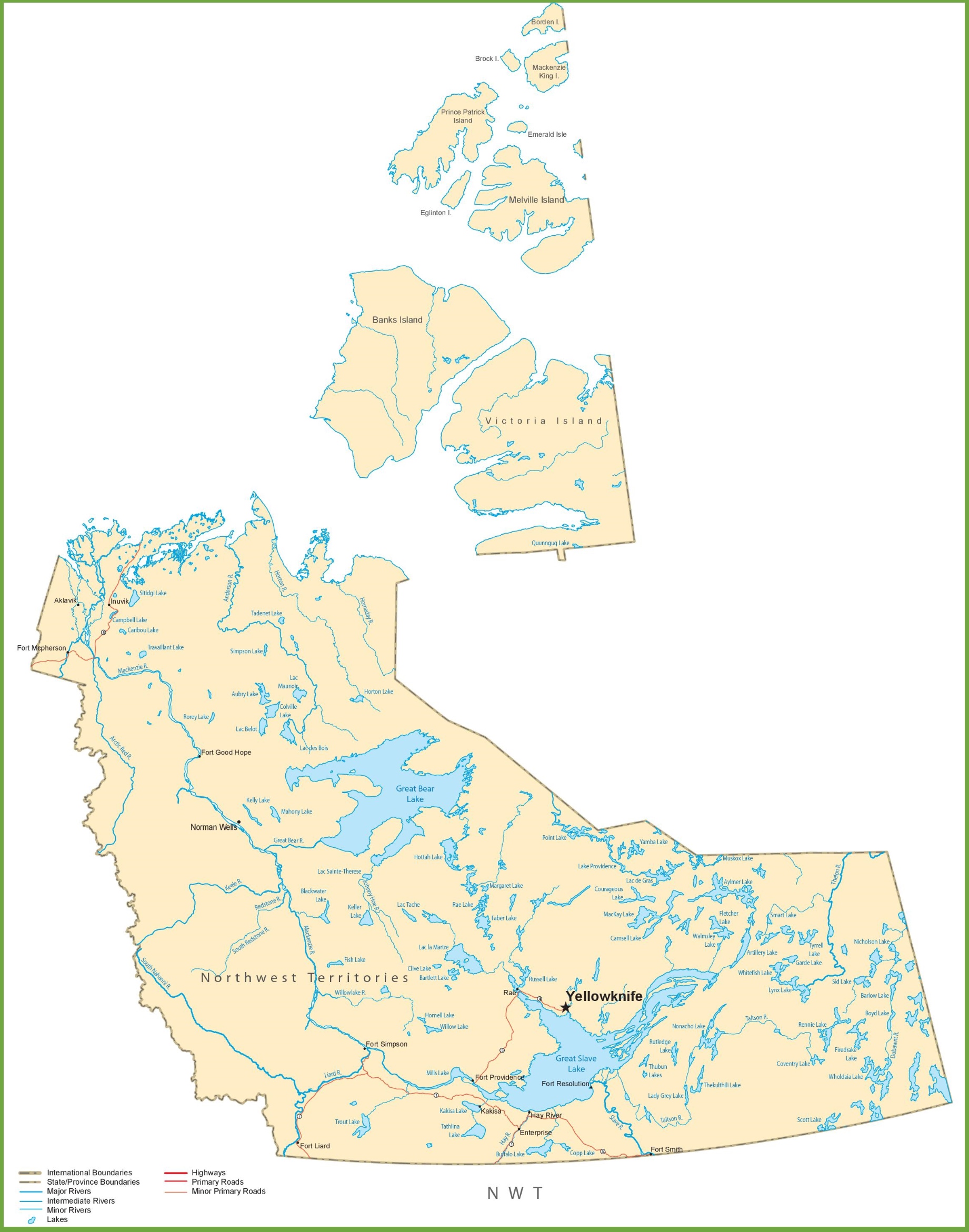
The Northwest Territories road map is a comprehensive visual guide to the region’s transportation network, displayed at a resolution of 1841×2341 pixels. It details the main highways and primary roads that connect the various communities and points of interest throughout the territory. The map also delineates international boundaries and state/province boundaries and includes symbols for major and minor rivers, lakes, and other significant natural landmarks. This map is essential for anyone traveling through the vast and often remote areas of the Northwest Territories, providing clear routes and geographical context.
Please visit this page for other map resources or Google Maps.
What This Road Map Offers
This road map of the Northwest Territories is incredibly comprehensive, showing all the major cities and towns, transportation routes, rivers, and lakes in the area. It also highlights the various airports, national parks, rest areas, welcome centers, Indian reservations, scenic byways, and points of interest. This map is handy for those planning a road trip as it shows all the highways, main roads, and secondary roads, including interprovince, Canada, and province highways.
Hotels, Resorts, and Other Points of Interest: For those looking for accommodations, the road map also shows the location of hotels, resorts, and other points of interest, such as beaches, national parks, rest areas, and welcome centers. It also highlights various tourist attractions and sightseeing opportunities, making planning an itinerary easy and getting the most out of your visit to the Northwest Territories.
Did You Know About the Northwest Territories?
- The Northwest Territories are home to indigenous peoples, including the Inuit, Dene, and Métis.
- The region is known for its stunning natural beauty, including the northern lights, pristine lakes and rivers, and vast forests.
- The Northwest Territories has a rich cultural heritage, with traditional music, art, and dance playing an essential role in the local communities.
- The region also has several annual festivals and events, such as the Great Northern Arts Festival and the Northern Lights Festival.
Conclusion
Exploring the Northwest Territories is an adventure of a lifetime, and having a comprehensive road map can help you make the most of your visit. The map on canadamaps.com is an excellent resource for anyone planning a trip to the region. It shows all the major cities and towns, transportation routes, national parks, rest areas, welcome centers, and other points of interest, making it easy to plan an itinerary and navigate around this stunning part of Canada.